From Balloons to Satellites: A Journey Through the Evolution of Remote Sensing and Satellite Imagery Resolution

Remote sensing is the science of gathering information about an object or phenomenon without making physical contact with it. This technology has revolutionised the way we view and understand our planet by allowing us to access vast amounts of information about the earth’s surface and atmosphere. Remote sensing has come a long way since its inception, and in this blog post, we will take a closer look at its history, and how resolution in satellite imagery has evolved over time.
The history of remote sensing can be traced back to the mid-19th century when the first aerial photographs were taken from hot air balloons. However, it wasn’t until the launch of the first artificial satellite, Sputnik 1, by the Soviet Union in 1957, that remote sensing began to take on a more significant role in scientific research. The launch of Sputnik 1, followed closely by Sputnik 2, marked the beginning of decades of rapid developments in satellite based remote sensing.
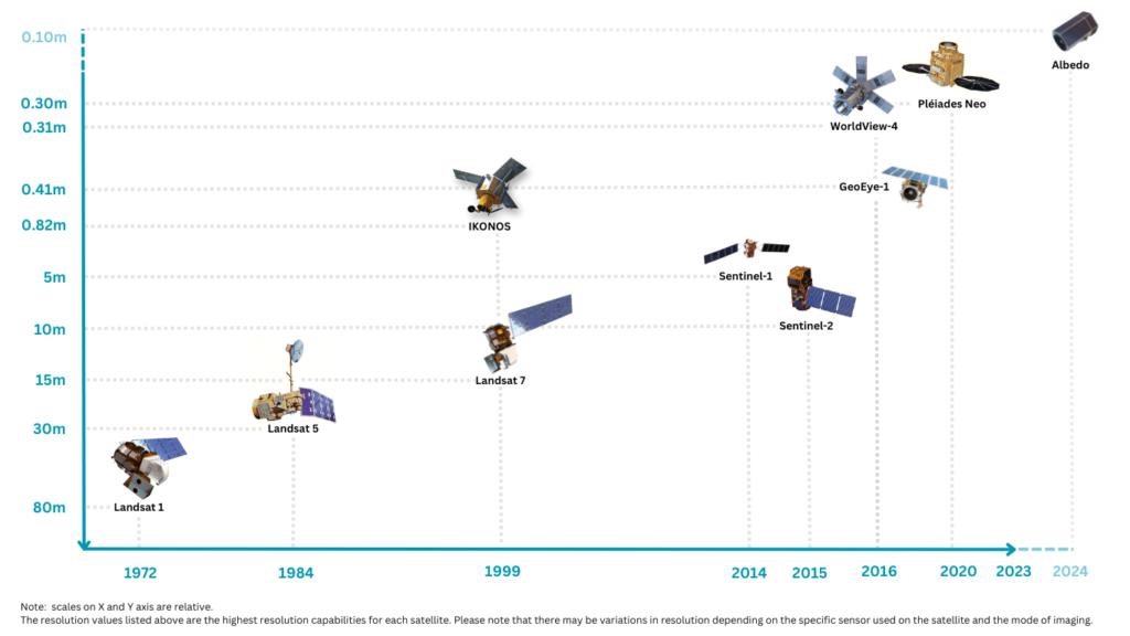
The launch of Landsat 1 in 1972 by the United States was a turning point in the evolution of satellite remote sensing. Landsat 1 was the first earth-observing satellite explicitly designed to study planet Earth. It carried the Return Beam Vidicon (RBV) and a Multispectral Scanner System (MSS), and provided a 80 meter-ground resolution and a swath width of 185 km.
Over the following years, the resolution of satellite imagery continued to improve significantly. In 1984, Landsat 5 was launched, equipped with a Multispectral Scanner System (MSS) and a Thematic Mapper (TM). Landsat 5 provided a spatial resolution of 30 metres and delivered Earth imaging data for almost 29 years, setting a Guinness World Record for ‘Longest Operating Earth Observation Satellite.
More than a decade later, in 1999, Landsat 7 was launched, featuring a panchromatic band with 15 metre spatial resolution. The same year, the IKONOS satellite sensor was launched by MAXAR Technologies Inc. IKONOS was the first commercial satellite to offer high-resolution imagery (0.80-meter panchromatic resolution at nadir) and was mostly used for urban and rural mapping, environmental monitoring, and national security. In 2013, Landsat 8 was launched, featuring 15-metre panchromatic and 30-metre multi-spectral spatial resolutions.
Another significant contributor to remote sensing was the Sentinel programme. The programme was launched by the European Space Agency (ESA) in partnership with the European Commission and consisted of a constellation of satellites called Sentinels, which provided high-resolution imagery of the earth’s surface and atmosphere.
The Sentinel satellites carried a range of sensors, including radar, optical, and thermal sensors, which provided high-resolution images of the Earth’s surface. One of the key Sentinel missions was Sentinel-2, which provided multispectral imagery with a spatial resolution of up to 10 metres.
Since then, other satellites that provide even higher resolution imagery have been launched. For instance, the GeoEye-1 satellite was launched in 2008 and provided a 0.41metres panchromatic resolution, while the WorldView-4 satellite, a third generation commercial earth observation satellite that was launched in 2016 offered high-resolution imagery at 31 cm resolution in panchromatic mode. More recently, Pléiades Neo, launched in 2020, reached a panchromatic resolution of 0.30 metres, making it one of the highest resolution commercial satellites currently in operation. In the near future, Albedo will be launching its constellation of 24 satellites with plans to complete it by 2027. The first of these satellites is expected to launch in 2024 and will provide a resolution of up to 0.10 metres.
In summary, the history of remote sensing has been shaped by a series of technological advancements that have revolutionised our ability to understand and manage the earth’s resources. From the launch of Sputnik 1 in 1957 to the latest Pléiades Neo, remote sensing has come a long way, providing increasingly accurate and high-resolution data that has enabled us to study the earth’s surface in much greater detail. As we look to the future, the potential applications of remote sensing continue to expand, offering exciting opportunities to address some of the most pressing environmental challenges facing our planet.
Recent Posts
")


")
")
- « Previous
- 1
- 2
- 3
- 4
- Next »