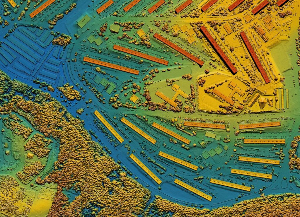
In the realm of remote sensing, LiDAR technology stands out as a transformative force that is ushering in a new era in topographic mapping, forestry management, and urban planning. In this article, we’ll explore how LiDAR works and the different ways it is revolutionizing these fields.
What is LiDAR?
Light Detection and Ranging or simply LiDAR is a remote sensing method used to examine the surface of the Earth. This technique employs light in the form of a pulsed laser to precisely measure distances and create detailed 3D representations of the Earth’s surface.
How does LiDAR work?
A LiDAR instrument usually consists of a laser, a scanner, and a specialized GPS receiver. It operates by emitting laser pulses into the environment and measuring the time it takes for those pulses to return to the sensor after bouncing off surfaces. The sensor then uses the time it took for each pulse to travel to the ground and back to calculate the distance it traveled, which is then converted to elevation data.
By repeating this process multiple times, it collects millions of data points, which are then used to construct accurate and detailed 3D maps of the Earth’s surface or objects.
LiDAR Applications
Lidar is used in many industries, including forestry, urban planning, mapping, and many more. Here’s a brief look at some of its applications.
Topographic Mapping
LiDAR has revolutionized topographic mapping by providing unparalleled accuracy and efficiency. It can capture details of the Earth’s surface, including elevation variations, landforms, and even underground features. Traditional methods, such as ground surveys, are time-consuming and less precise in comparison. Moreover, LiDAR has become the cornerstone of digital elevation models (DEMs) used in a wide range of fields, from civil engineering to environmental science.
Forestry Management
LiDAR offers a transformative perspective on forest inventory and management. By scanning vast forested areas from the air, LiDAR sensors can accurately assess tree height, density, and distribution. This information is invaluable for sustainable forest management, enabling precise decisions about harvesting, reforestation, and conservation.
Precision Farming
In agriculture, LiDAR technology offers precision farming capabilities. It enables detailed crop health monitoring, soil analysis, and yield prediction. Farmers can optimize resource use, including water, fertilizers, and pesticides, by tailoring applications to specific field needs. Additionally, LiDAR aids in early pest and disease detection, promoting sustainable and efficient agricultural practices.
Urban Planning and Development
LiDAR plays a pivotal role in urban planning and development. It enables the creation of highly detailed 3D models of cities and their infrastructures. Planners and architects can also use LiDAR data to assess the impact of proposed projects, optimize transportation networks, and analyze urban growth patterns.
Robotics
LiDAR technology can also be used to equip robots, including autonomous vehicles and drones, with mapping and navigation capabilities. LiDAR sensors on these robots emit laser pulses to measure the distance between the vehicle and surrounding objects or obstacles in the environment. By continuously scanning its surroundings and analyzing the time it takes for the laser pulses to return, the robot can create detailed 3D maps of its environment, which are crucial for autonomous systems to navigate safely and avoid collisions.
Challenges and Advancements of LiDAR
While LiDAR technology offers remarkable advantages, it also presents challenges. Data processing and storage requirements can be substantial, and the cost of LiDAR equipment and data acquisition can be a barrier for some applications. However, ongoing advancements in sensor miniaturization, automation, and data analysis are making LiDAR more accessible and cost-effective.
Conclusion
LiDAR technology is a true game-changer in the world of remote sensing. Its ability to capture highly accurate 3D data has transformed many industries. As technology continues to advance, LiDAR’s impact will only expand, offering innovative solutions to an array of challenges in environmental management, infrastructure development, and beyond.
For organizations seeking to harness the power of LiDAR data and extract valuable insights, our AI-powered platform, FlyPix AI, stands ready to assist. With FlyPix AI, you can efficiently process and analyze LiDAR data, unlocking critical information to inform your business decisions and drive success in your projects. To explore the capabilities of FlyPix AI firsthand, don’t hesitate to contact us today.


