
In our roundup of the best LiDAR-equipped drones for professional use, systems that combine UAVs with LiDAR sensors stand out for their ability to create highly accurate 3D point clouds of terrain, vegetation, and structures. Unlike standard drone cameras that capture only surface visuals (photogrammetry), LiDAR (Light Detection and Ranging) works by emitting rapid laser pulses—often hundreds of thousands per second—that bounce off objects and return to the sensor.
By precisely timing these returns, the system calculates distances and builds detailed elevation models, penetrating dense foliage to reveal ground topography and delivering centimeter-level accuracy even in low-light or challenging environments.
This technology is essential for surveying, forestry, mining, infrastructure inspection, and environmental monitoring, where traditional methods fall short. Leading professional drones like the DJI Matrice 350 RTK with Zenmuse L2, WingtraOne GEN II with various LiDAR payloads, or specialized platforms from Microdrones and Riegl integrate LiDAR seamlessly, enabling faster data collection over large areas with minimal ground control points—making them indispensable tools for engineers, land surveyors, and researchers seeking reliable, high-precision results.
FlyPix AI: Powerful AI Platform for Analyzing Drone LiDAR Data
At FlyPix we work with drone and LiDAR data on the analysis side rather than the flight side. In projects where drones are used to collect LiDAR scans, our role usually starts once the data is captured. We help teams work with aerial and LiDAR-derived datasets by detecting objects, tracking changes, and reviewing patterns across large areas without relying on manual inspection alone.
In a drone with LiDAR workflow, this often means combining LiDAR outputs with drone imagery to get more context. LiDAR can describe structure and elevation, while imagery adds visual detail. We support this mix by letting teams upload drone data, train models on their own examples, and review results through maps and dashboards. The focus stays on understanding what changed, where it happened, and how it affects the project at hand.
Exploring the Best Drones with Lidar
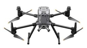
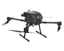
1. DJI Matrice 350 RTK
The Matrice 350 RTK is a heavy-duty drone platform often used as a carrier for LiDAR payloads. It is built to handle longer flights, higher payload weights, and challenging environments, which makes it a common choice when LiDAR sensors are involved. The platform itself does not define the data quality, but it creates stable conditions for collecting it.
In drone with LiDAR setups, this model is usually paired with third-party LiDAR systems. Its flight stability, positioning support, and multi-payload design make it suitable for surveying, inspection, and mapping tasks where consistent flight paths matter. It is often chosen for professional operations where downtime or signal loss can disrupt data collection.
Key Highlights:
- Supports LiDAR and other professional payloads
- Designed for long and stable flight operations
- RTK positioning for precise navigation
- Strong transmission and safety systems
- Used in industrial and survey-focused missions
Who it’s best for:
- Survey teams flying LiDAR payloads
- Industrial inspections requiring stable platforms
- Mapping projects with complex flight routes
- Operators working in varied weather conditions
2. Freefly Astro
Astro is a modular drone platform designed around payload flexibility. In drone with LiDAR use cases, it is often selected when teams need control over sensors, lenses, or custom hardware setups. The system is built to support precise positioning and integrates well with professional payloads, including LiDAR and range-finding equipment.
Rather than focusing on automation alone, Astro is often used in workflows where operators want more control over how data is captured. This can matter for LiDAR missions that require specific flight patterns, altitudes, or sensor configurations. Its open ecosystem approach makes it easier to adapt the drone to different project needs.
Key Highlights:
- Modular design for custom payload setups
- Compatible with LiDAR and advanced sensors
- RTK and positioning support
- Focus on precise and controlled data capture
- Often used in specialized survey workflows
Who it’s best for:
- Teams building custom drone with LiDAR setups
- Projects needing flexible sensor configurations
- Operators who want more control over flights
- Advanced mapping and inspection tasks
3. Inspired Flight IF1200
The IF1200 is a heavy-lift drone platform designed to support complex aerial workflows, including LiDAR-based mapping. They approach this platform as a flexible carrier rather than a fixed-purpose drone. The airframe is built to handle different sensor types, which allows teams to switch between LiDAR, optical, or mixed payload setups depending on the job, without changing the core system.
When used for drone with LiDAR operations, they tend to focus on stability, repeatability, and predictable flight behavior. The platform is commonly paired with third-party LiDAR sensors and is meant to fit into structured survey or inspection workflows. Instead of pushing automation as the main story, the design leans toward giving experienced operators control over how data is captured in demanding environments.
Key Highlights:
- Heavy-lift platform compatible with LiDAR payloads
- Designed for repeatable mapping and inspection workflows
- Supports multiple payload types without airframe changes
- Built for regulated and professional use cases
Who it’s best for:
- Survey teams working with drone-mounted LiDAR
- Operators handling infrastructure or corridor mapping
- Organizations needing a configurable aerial platform
4. Watts Innovations PRISM Sky
PRISM Sky is positioned as a UAS platform that can be adapted for tasks like LiDAR scanning alongside other heavy payload operations. They present it as part of a broader ecosystem rather than a single aircraft, with the drone working together with their ground control system, batteries, and accessories. This makes it easier to build a consistent workflow around data capture missions.
For drone with LiDAR use cases, they frame PRISM Sky as a carrier that prioritizes reliability and system-level integration. Instead of focusing on sensor innovation, the emphasis is on providing a stable aerial base that LiDAR providers can integrate into existing service models, whether for surveying, inspection, or scanning work.
Key Highlights:
- Heavy-lift drone designed for modular payload setups
- Can be configured for LiDAR scanning workflows
- Part of a wider hardware and control ecosystem
- Built with long-term operational use in mind
Who it’s best for:
- Drone service providers offering LiDAR services
- Teams needing a US-made, compliant drone platform
- Operators combining cargo, inspection, and scanning tasks
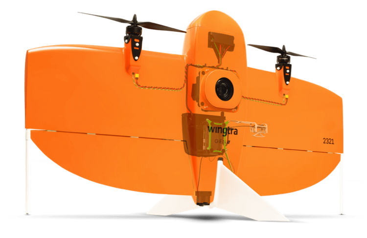
5. WingtraOne
WingtraOne is primarily known as a mapping drone, and their approach to drone with LiDAR workflows is more indirect. They focus on producing consistent geospatial data and fitting smoothly into existing surveying processes. While they are often associated with photogrammetry, their workflow supports point cloud generation and integration with LiDAR processing tools used downstream.
Rather than positioning the drone itself as a LiDAR carrier, they emphasize data compatibility and accuracy across surveying projects. For teams working with LiDAR data alongside other spatial datasets, WingtraOne is often used to complement LiDAR missions by filling gaps, validating results, or supporting hybrid mapping workflows.
Key Highlights:
- Designed for large-area mapping and surveying
- Integrates with standard point cloud and LiDAR software
- Focus on consistent and repeatable data capture
- Fits into existing survey and GIS workflows
Who it’s best for:
- Surveyors combining LiDAR and photogrammetry data
- Mapping teams working across large sites
- Organizations focused on standardized geospatial outputs
6. Arcsky X55
The Arcsky X55 is built around a modular heavy lift design that supports different power and payload setups, including LiDAR systems. Its structure allows operators to switch between power modules depending on mission needs, which is useful when balancing endurance, payload weight, and operational downtime. In LiDAR workflows, this flexibility matters because survey requirements can change from long corridor mapping to shorter, denser scans.
From a LiDAR perspective, the X55 is typically used as a stable carrier rather than a tightly integrated sensing platform. It provides the lift capacity and flight stability needed to carry airborne LiDAR sensors alongside positioning equipment. The focus here is not on automation or onboard processing, but on giving survey teams a reliable airframe that fits into existing data capture and processing pipelines.
Key Highlights:
- Modular power system that supports different mission profiles
- Payload capacity suitable for LiDAR and multi-sensor setups
- Designed for repeatable industrial survey workflows
- Compatible with mapping, inspection, and corridor survey use cases
Who it’s best for:
- Survey teams running LiDAR on custom or third-party sensors
- Operators who need flexibility between endurance and payload weight
- Industrial users working in infrastructure or large area mapping
7. Skyfront Perimeter 8
Skyfront Perimeter 8 is a hybrid gas electric multicopter designed for long endurance flights with heavier payloads, including LiDAR systems. Its main role in LiDAR work is enabling longer continuous data collection without frequent landings, which can reduce gaps in coverage and simplify large scale survey planning.
In LiDAR missions, the Perimeter 8 is usually selected for projects where time in the air matters more than compact size or fast deployment. It acts as a long range carrier that can support LiDAR mapping, geophysical surveys, or wide area scans. The platform itself stays largely in the background while the payload and downstream data processing do the heavy lifting.
Key Highlights:
- Hybrid power system focused on extended flight endurance
- Payload support suitable for LiDAR and geophysical sensors
- Designed for long distance and wide area survey missions
- Fits into professional mapping and exploration workflows
Who it’s best for:
- LiDAR surveys covering large or remote areas
- Teams prioritizing long continuous flight time
- Mapping and exploration projects with fewer launch sites
8. Harris Aerial Carrier H6 Electric
The Harris Aerial Carrier H6 Electric is a fully electric heavy lift hexacopter designed for flexible payload integration, including LiDAR units. Its modular payload bay and battery powered setup make it a practical option for teams that want predictable flight behavior and simpler field logistics compared to fuel based systems.
When used for LiDAR, the H6 Electric focuses on stability, control, and clean power delivery rather than maximum endurance. It supports structured survey missions such as site mapping, inspection, or targeted area scans. The platform fits well into workflows where repeatability and ease of setup matter more than extreme range.
Key Highlights:
- Fully electric heavy lift platform
- Modular payload bay for LiDAR and imaging sensors
- Supports autonomous and planned survey missions
- Foldable design for easier transport and setup
Who it’s best for:
- LiDAR surveys on defined sites or corridors
- Teams preferring electric power and simpler maintenance
- Operators running mixed sensor payloads in planned missions
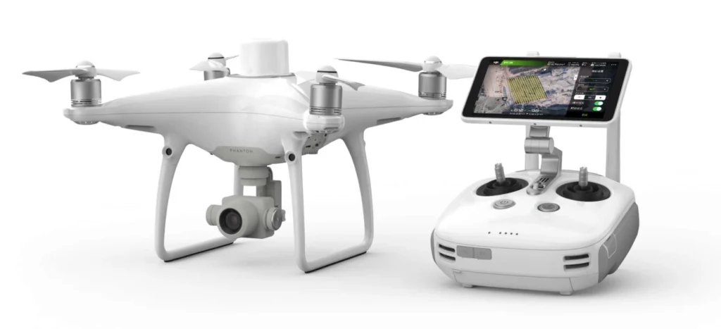
9. DJI Phantom 4 RTK
DJI Phantom 4 RTK is a compact multirotor drone designed for structured mapping tasks. Its strength comes from how tightly flight control, positioning, and data capture are integrated. While it is not a heavy-lift platform, it often appears in drone with LiDAR discussions because of its role in accurate low-altitude mapping and reference data collection.
In LiDAR-related workflows, this type of drone is often used alongside other sensors or platforms rather than as a primary LiDAR carrier. It can support projects where precise positioning, repeatable flight paths, and clean image alignment are needed. This makes it useful for validating LiDAR outputs or combining surface imagery with elevation data.
Key Highlights:
- Multirotor platform with integrated positioning systems
- Designed for structured mapping missions
- Stable flight for consistent image capture
- Often used alongside LiDAR data rather than replacing it
- Compact and easy to deploy in the field
Who it’s best for:
- Teams combining LiDAR data with visual mapping
- Surveyors working in confined or urban areas
- Projects needing reliable reference imagery
- Operators who prefer simple, repeatable workflows
10. Freefly Alta X
Freefly Alta X is a heavy-lift multirotor built to carry demanding payloads with stable control. Its design focuses on flexibility, making it suitable for different sensor setups, including LiDAR systems. In drone with LiDAR operations, platforms like this are typically chosen when payload weight, sensor size, or custom configurations are part of the project.
Alta X fits into workflows where LiDAR hardware needs space, power, and steady flight conditions. It is often used for detailed scanning tasks where precision matters more than covering long distances. The platform supports controlled flight patterns that help maintain consistent sensor orientation and data quality.
Key Highlights:
- Heavy-lift multirotor designed for larger payloads
- Supports LiDAR and other specialized sensors
- Stable flight behavior for controlled scanning
- Flexible setup for different mission needs
- Common in inspection and detailed survey work
Who it’s best for:
- Teams flying LiDAR systems that require heavier platforms
- Projects needing precise, localized scanning
- Operators using custom or modular sensor setups
- Workflows focused on data quality over coverage speed
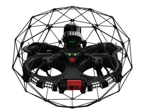
11. Flyability Elios 3
Elios 3 is built for places most drones simply cannot reach. It is designed for indoor inspection and mapping in tight, enclosed, or hard to access environments where GPS is unavailable and visual conditions are often poor. Instead of focusing on open-area surveying, it supports teams that need to understand the structure and condition of industrial assets from the inside, such as tanks, tunnels, shafts, or complex facilities.
In a drone with LiDAR context, Elios 3 is used to capture spatial data in environments where traditional LiDAR drones cannot operate. Its onboard LiDAR and visual systems work together to create 3D representations of confined spaces while the drone remains stable and collision tolerant. This allows teams to move from visual checks to spatial understanding, using the collected data to review geometry, plan maintenance, or document asset conditions without sending people into risky areas.
Key Highlights:
- Designed for indoor and confined space inspection
- Uses LiDAR and vision together for 3D mapping
- Collision tolerant airframe for close-range work
- Real-time 3D visualization during flight
- Focused on inspection, mapping, and documentation rather than open-area surveys
Who it’s best for:
- Industrial teams inspecting confined or enclosed assets
- Operations working in GPS-denied environments
- Projects where safety limits human access
- Teams that need spatial context, not just video footage
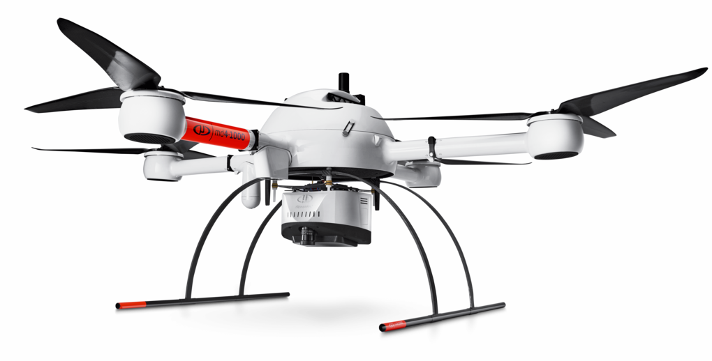
12. Microdrones mdLiDAR1000
mdLiDAR1000 is an integrated drone LiDAR system built around a complete workflow rather than just a single aircraft or sensor. It is typically used in outdoor environments where structured, repeatable data collection is required for mapping terrain, infrastructure, or large sites. The system combines the drone, LiDAR payload, and software into a single setup that supports consistent point cloud generation.
Within a drone with LiDAR workflow, mdLiDAR1000 fits teams that want a straightforward path from flight to usable spatial data. The focus is on reliable LiDAR capture over corridors, sites, and natural landscapes, followed by processing that turns raw scans into structured outputs. Instead of experimenting with mixed hardware, users work within a defined system that supports surveying, monitoring change over time, and building terrain models.
Key Highlights:
- Integrated drone and LiDAR system
- Designed for structured geospatial data collection
- End-to-end workflow from planning to processing
- Focus on point cloud generation for outdoor environments
- Supports repeatable surveys across the same areas
Who it’s best for:
- Surveying and geospatial professionals
- Teams running outdoor LiDAR mapping projects
- Infrastructure and construction monitoring work
- Projects that rely on consistent point cloud outputs
Conclusion
Wrapping it up, drones paired with LiDAR have quietly changed how people look at space, structure, and change. What used to take long fieldwork or rough estimates can now be captured from above with a level of detail that actually holds up in real projects. The real value is not just the data itself, but how consistently it can be collected and compared over time.
At the same time, the setup matters. Hardware, sensors, and analysis tools all play different roles, and none of them work well in isolation. The most effective workflows tend to be the ones where flight, data capture, and interpretation fit together without forcing teams to overthink each step. When that balance is right, drone with LiDAR stops being a fancy tool and becomes a practical way to understand what is really happening on the ground.