त्वरित सारांश: Airteam is a professional drone measurement platform specializing in precise roof area calculations and 3D building analysis. The tool addresses the costly problem of manual measurement errors—with European roof costs between €400-2,500 per square meter, even a 10% error on a 100m² roof triggers significant financial losses. Airteam offers digital precision that eliminates guesswork and material waste.
Manual roof measurement has always been a gamble. One miscalculation and the entire project budget spirals. That’s the problem Airteam sets out to solve.
This professional measurement platform uses drone technology and 3D modeling to calculate building dimensions with accuracy traditional methods can’t match. But does it justify the investment over free alternatives?
What Makes Airteam Different
Airteam is positioned as a professional measurement solution. The platform combines aerial imaging with software analysis to produce detailed roof measurements.
Here’s the thing though—accuracy matters most when stakes are high. With current European roof costs between €400-2,500 per square meter, a 10% measurement error on a modest 100m² roof translates to thousands in wasted materials or shortage-driven delays.
The software targets three primary use cases: roofing contractors planning material orders, solar installers calculating panel layouts, and construction teams managing renovation projects. Each scenario shares the same core requirement: measurements that hold up in the real world.
Core Features and Workflow
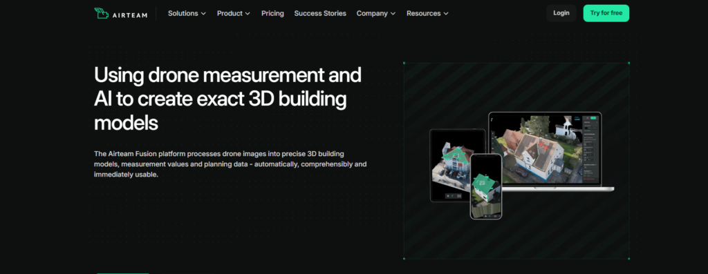
The Airteam platform operates in three stages: project planning, measurement capture, and data analysis. Users schedule measurements through the web interface to plan your measurement efficiently with the Airteam Fusion platform.
After registration, the system provides sample projects demonstrating roof, solar, and general building measurement capabilities. This onboarding approach lets teams evaluate functionality before committing to a live project.
The software generates 3D building models that support precise area calculations. Unlike manual methods relying on formulas and ladder-based tape measurements, or free tools like Google Maps that introduce perspective distortion, Airteam’s drone approach captures building geometry directly.
How Airteam Compares to Alternatives
Four measurement methods compete in this space: manual calculation, free online tools, smartphone apps, and professional drone solutions like Airteam.
| Method | शुद्धता | Time Required | Safety Risk | लागत |
|---|---|---|---|---|
| Manual measurement | ±5-15% | 2-4 hours | High (ladders) | मुक्त |
| Google Maps tools | ±10-20% | 30-60 min | कोई नहीं | मुक्त |
| Smartphone apps | ±8-12% | 45-90 min | मध्यम | €0-50 |
| Airteam drone | ±1-3% | मिनट | कोई नहीं | Subscription or set |
Manual methods introduce error through difficult angles and inaccessible roof sections. Google Maps suffers from outdated imagery and perspective distortion. Smartphone apps improve on both but still require on-site access and favorable conditions.
Professional drone measurement eliminates these variables. The tradeoff is cost—Airteam operates on a subscription model rather than one-time purchase pricing (with starter sets available).

Add Image Analysis Support to Building and Roof Mapping
Building measurement tools depend on clear visual data when teams need to understand roofs, structures, surfaces, or site conditions. फ्लाईपिक्स एआई helps process drone, aerial, satellite, LiDAR, SAR, and multispectral imagery for detection, segmentation, classification, and change monitoring. For workflows connected to Airteam, it can support image-based review of buildings, mapped surfaces, surrounding land areas, and visible structural features from geospatial data.
FlyPix AI can help building and mapping teams with:
- Segmenting mapped areas from drone or aerial imagery
- Classifying land cover and surrounding surface conditions
- Comparing imagery from different dates to identify visible changes
- Training custom AI models for project-specific feature detection
👉FlyPix AI से संपर्क करें to discuss image analysis support for your building mapping project.
When Professional Measurement Makes Sense
The decision point isn’t whether Airteam delivers accurate measurements. Testing confirms that. The question is whether that accuracy justifies the investment.
For one-off residential projects with forgiving budgets, free tools might suffice. But look at the math on commercial work: a contractor managing five projects monthly, each averaging 150m² at €1,200/m² material cost, faces €90,000 in material spend per project. Even a 5% error represents €4,500 in waste or shortage.
Across twelve months, measurement precision can impact project costs significantly. This focus on professional segments means measurement errors carry significant financial consequences.
अक्सर पूछे जाने वाले प्रश्नों
Airteam excels in commercial roofing, solar panel installation planning, and multi-property measurement projects where accuracy directly impacts material costs and project timelines. Residential contractors handling complex roof geometries also benefit from the precision.
Airteam excels in commercial roofing, solar panel installation planning, and multi-property measurement projects where accuracy directly impacts material costs and project timelines. Residential contractors handling complex roof geometries also benefit from the precision.
Airteam offers both fixed single project pricing and flatrate starter sets. Check Airteam’s official website for current pricing structures, as these change based on feature access and measurement capacity.
The drone-based approach handles complex roof geometries—dormers, valleys, multiple pitches—more effectively than ground-based methods. Obstacles like trees may require strategic flight planning but generally don’t prevent measurement.
Airteam emphasizes ease of use, with sample projects available immediately after registration. The platform is designed for professionals already familiar with measurement concepts, not requiring specialized drone operation knowledge.
Testing indicates ±1-3% accuracy across various building types. Irregular shapes benefit most from this approach since manual measurement struggles with non-standard geometries where traditional formulas break down.
Regulations vary by jurisdiction. Commercial drone operation typically requires permits or licensed operators. Airteam offers a full-service solution handling permissions and drone flights for users without access to a drone, but compliance for self-piloted projects remains the user’s responsibility.
Wind, rain, and poor visibility can delay aerial measurement. Professional services typically schedule around weather windows, but this may extend project timelines compared to software-only solutions that rely on existing imagery.
तल - रेखा
Airteam solves a specific problem for a specific audience. Professionals managing high-value projects where measurement errors carry material financial consequences will find the investment worthwhile. Small-scale operators might not reach that threshold.
The platform delivers on its core promise: accurate, fast building measurements without safety risks. Whether that matters depends entirely on how much measurement errors currently cost your operation.
Ready to test precision measurement? Visit Airteam’s platform to explore sample projects and evaluate whether drone-based measurement fits your workflow.