

Water Erosion: Types, Causes, Effects & Prevention 2026
Quick Summary: Water erosion involves the detachment and transport of soil particles by rainfall and runoff, affecting agricultural productivity and land stability. It manifests in five main types: splash, sheet, rill, gully, and tunnel erosion. Prevention requires a combination of vegetative cover, contour farming, terracing, and proper water management strategies tailored to each erosion type.
Every year, billions of tonnes of fertile topsoil disappear from farmland worldwide. The culprit? Water erosion—one of the most destructive natural processes affecting agricultural land and built environments alike.
Water doesn’t just trickle away harmlessly. When rain hits bare soil or runoff gains momentum, it carries away the nutrient-rich surface layer that supports crops, beneficial organisms, and entire ecosystems. According to the University of Delaware Cooperative Extension, the world’s six billion people depend on only 11% of the world’s land for all of its food needs—and only about 3% of the planet’s land surface is considered suitable for agriculture.
Here’s the thing though—water erosion isn’t a single phenomenon. It takes different forms depending on terrain, rainfall intensity, soil type, and land management practices. Understanding these distinctions matters because each type demands specific prevention strategies.
What Is Water Erosion?
Water erosion is the process by which soil particles are detached, transported, and deposited elsewhere by the force of water. This includes both rainfall impact and surface runoff.
The process begins the moment a raindrop hits exposed soil. That impact dislodges particles, sending them airborne. Then gravity and flowing water take over, carrying these particles downslope until the water loses energy and deposits them somewhere else—often in places where they cause additional problems like clogged drainage systems or polluted waterways.
Research from the Agricultural Research Service (ARS) shows that understanding water erosion requires examining both the immediate mechanical forces at work and the longer-term landscape changes they produce. Ron Bingner, research leader with the Watershed Physical Processes Research Unit at the National Sedimentation Laboratory, focuses on predicting and controlling sediment yield and evaluating management systems to reduce erosion.
But water erosion doesn’t affect all land equally. Slope, soil composition, vegetative cover, and rainfall patterns all determine how severe erosion becomes.
The Five Main Types of Water Erosion
Water erosion manifests in five distinct forms, each with unique characteristics and challenges.
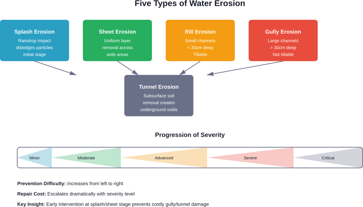
Splash Erosion
Splash erosion occurs when raindrops strike bare soil with enough force to dislodge particles. Each raindrop strikes bare soil with force, dislodging particles.
This is the first stage of water erosion. While it might seem minor, splash erosion sets the stage for more severe forms by loosening soil and making it vulnerable to runoff.
Sheet Erosion
Sheet erosion removes soil in relatively uniform thin layers across wide areas. Runoff flows as a sheet rather than in defined channels, carrying away the loosened particles from splash erosion.
This type is particularly insidious because it’s difficult to detect until significant soil loss has occurred. The land simply becomes gradually less productive over time.
Sheet erosion typically follows splash erosion and represents the transition from particle detachment to actual transport and removal of soil material.
Rill Erosion
Rill erosion creates small, shallow channels—typically less than 30 centimeters deep—where concentrated water flow cuts into the soil. These channels are still small enough to be smoothed over by normal tillage operations.
Rills form when runoff water concentrates into small streams rather than flowing as a sheet. The concentrated flow has more erosive power, cutting progressively deeper channels. Rill erosion is typically less than 30 centimeters deep and can be removed by normal tillage operations.
Agricultural fields with visible rill patterns after heavy rain indicate moderate to advanced water erosion problems that need immediate attention.
Gully Erosion
Gully erosion produces large channels deeper than 30 centimeters that cannot be removed by ordinary tillage. These are the dramatic scars across landscapes that signal severe erosion.
Gullies form when rill erosion goes unchecked. The concentrated flow deepens and widens the channel, creating permanent landscape features that fragment farmland and require expensive rehabilitation.
Once established, gullies continue expanding through headward erosion (cutting backward into the slope) and sidewall collapse, consuming more land with each storm event.
Tunnel Erosion
Tunnel erosion—also called piping—occurs beneath the soil surface when water infiltrates through cracks and disperses soil particles underground. This creates subsurface voids or tunnels that eventually collapse, forming surface depressions and gullies.
This type is particularly dangerous because the damage remains invisible until catastrophic surface collapse occurs. Land that appears stable can suddenly give way under equipment or livestock.
Tunnel erosion typically affects soils with dispersive clays or significant differences in permeability between soil layers.
Primary Causes of Water Erosion
Water erosion doesn’t happen in isolation. Multiple factors interact to determine whether erosion occurs and how severe it becomes.
Rainfall Intensity and Duration
The kinetic energy of raindrops provides the initial force for erosion. Heavier rainfall means larger drops with more impact force, while longer duration means more total water volume and sustained runoff.
Research on river bluff erosion in the Greater Blue Earth River basin found that even small flows, a mere 30% of the two-year recurrence interval flow, are capable of causing bluff erosion. However, the 1.2-year return interval flood accomplished the most cumulative erosion over time due to frequency—highlighting that repeated moderate events often cause more total damage than rare extreme events.
Soil Properties
Soil texture, structure, and organic matter content all influence erodibility. Sandy soils lack cohesion and erode easily, while clay soils can be highly erodible when dispersive. Soils with good structure and high organic matter resist erosion better.
According to the Natural Resources Conservation Service (NRCS), soil information is critical for agricultural producers making land management decisions. Most of the world’s food and fiber production directly depends on soil as a growth medium and nutrient supply mediator.
Slope Steepness and Length
Water gains velocity and erosive power as it flows downhill. Steeper slopes mean faster-moving water with greater capacity to detach and transport soil particles.
Longer slopes allow runoff to accumulate volume and momentum. A gentle slope that’s very long can experience severe erosion because water has distance to build destructive force.
Vegetative Cover
Vegetation protects soil in multiple ways: plant canopies intercept rainfall and reduce impact force, roots bind soil particles together, stems slow runoff velocity, and plant residue creates a protective mulch layer.
Bare soil is exponentially more vulnerable to all types of water erosion. This explains why erosion rates spike dramatically after land clearing, overgrazing, or between crop cycles when fields sit exposed.
Land Management Practices
How land is managed fundamentally affects erosion rates. Conventional tillage that leaves soil bare and breaks down soil structure accelerates erosion. Practices that compact soil reduce infiltration and increase runoff.
According to FAO’s assessment of human-induced land degradation, 34% of agricultural land—approximately 1,660 million hectares—shows signs of human-induced degradation where soil is eroded, nutrients are depleted, and productivity declines.
Effects and Consequences of Water Erosion
Water erosion creates cascading problems that extend far beyond the eroded land itself.
Loss of Fertile Topsoil
Erosion preferentially removes the nutrient-rich topsoil layer where organic matter concentrates and where most biological activity occurs. This cannot be quickly replaced—natural soil formation is measured in decades or centuries.
The University of Delaware notes that erosion degrades soil quality by washing away the nutrient-rich surface layer that supports plants, beneficial organisms, and human populations.
Reduced Agricultural Productivity
As topsoil disappears, crop yields decline. The remaining subsoil has poorer structure, lower nutrient content, reduced water-holding capacity, and less beneficial biological activity.
Research from FAO linking land degradation to socioeconomic risks confirms that soil erosion is associated with reduced agricultural productivity and increased yield gaps.
Water Quality Degradation
Eroded sediment is the number one pollutant in waterways. Suspended sediment clouds water, blocks sunlight for aquatic plants, clogs fish gills, and smothers spawning beds.
The USGS study of the Jemez Canyon Dam documented how construction and operation of dams affect downstream sediment fluxes. While dams provide clean drinking water and flood control, they also trap sediment that would naturally nourish downstream ecosystems.
Sediment also carries adsorbed nutrients (especially phosphorus) and pesticides, contributing to eutrophication and chemical pollution of water bodies.
Infrastructure Damage
Eroded soil accumulates in drainage ditches, culverts, and storm sewers, reducing their capacity and causing localized flooding. Gully erosion undermines roads, foundations, and utilities.
The sediment must be dredged and disposed of at significant cost. Construction projects face delays when erosion control measures fail.
Ecosystem Disruption
Erosion alters landscape hydrology, destroys habitat, and changes nutrient cycling. Wetlands fill with sediment. Stream channels incise or aggrade, disconnecting rivers from their floodplains.
Research on marsh edge erosion and coastal bluff recession shows how erosion mechanisms vary by environment but consistently disrupt ecosystems and natural processes.
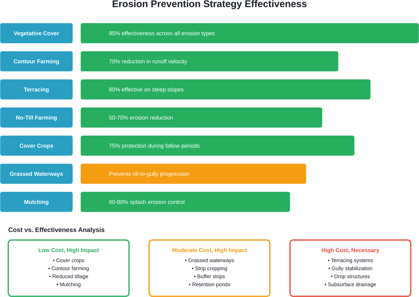
Effective Prevention and Control Strategies
The good news? Water erosion is largely preventable. The key is matching control measures to specific erosion types and site conditions.
| Control Measure | Splash | Sheet | Rill | Gully | Tunnel | Effectiveness |
|---|---|---|---|---|---|---|
| Maintaining vegetative cover | ✓ | ✓ | ✓ | ✓ | ✓ | High for all types |
| Enriching soil with organic matter | ✓ | ✓ | ✓ | ✓ | — | Improves soil structure |
| Reducing tillage intensity | ✓ | ✓ | ✓ | — | — | Moderate for early stages |
| Contour farming | ✓ | ✓ | ✓ | — | — | Reduces runoff velocity |
| Terracing | — | ✓ | ✓ | ✓ | — | High for steep slopes |
| Grassed waterways | — | — | ✓ | ✓ | — | Channels concentrated flow |
| Check dams and retention | — | — | — | ✓ | — | Slows gully expansion |
| Subsurface drainage improvement | — | — | — | — | ✓ | Essential for tunnel erosion |
Maintain Vegetative Cover
This is the single most effective erosion control strategy. Living plants, crop residues, cover crops, mulches, and permanent vegetation all provide protection.
Cover crops planted during fallow periods keep soil covered and roots in the ground year-round. Perennial vegetation on marginal land, field borders, and waterways provides permanent protection.
The key is maximizing ground cover during high-risk periods—typically the wet season in most climates.
Implement Contour Farming
According to competitor analysis content on contour farming, contour farming means planting horizontal rows along slopes that form hundreds of small dams, and this approach can reduce soil erosion by significant amounts.
Each crop row acts as a small barrier that slows runoff and increases water infiltration. This prevents runoff from building the velocity needed for rill and gully formation.
Contour farming works best on slopes between 2% and 10%. Steeper slopes need additional measures.
Build Terraces on Steep Slopes
Terracing converts long steep slopes into a series of shorter, flatter segments separated by embankments or channels. This dramatically reduces runoff velocity and erosive power.
Terraces require significant initial investment but provide long-term erosion control on otherwise vulnerable land. They’re essential for sustainable agriculture on hilly terrain.
Modern terrace systems incorporate grassed waterways to safely convey accumulated runoff off the field without causing erosion.
Reduce Tillage Intensity
Conservation tillage systems that leave crop residue on the soil surface provide physical protection against raindrop impact while improving soil structure over time.
No-till farming eliminates tillage entirely, maintaining maximum soil cover and minimizing disturbance. This preserves soil structure, increases organic matter, and enhances infiltration.
The transition to reduced tillage requires adjustments to planting equipment and weed management, and many practitioners report significant erosion reduction compared to conventional tillage.
Install Grassed Waterways
Grassed waterways are vegetated channels designed to safely convey concentrated runoff across farmland without causing erosion. They’re placed in natural drainage routes where rill and gully erosion would otherwise occur.
The dense grass slows water velocity and filters sediment. Properly designed and maintained grassed waterways can handle substantial flow volumes without damage.
Improve Soil Health
Healthy soils with good structure, high organic matter, and active biological communities resist erosion better. Practices that build soil health include adding compost, using cover crops, minimizing compaction, and maintaining crop diversity.
Soil organic matter acts like a sponge, improving water infiltration and reducing runoff. It also binds soil particles into stable aggregates that resist detachment.
Address Gully and Tunnel Erosion
Advanced erosion requires structural intervention. Gullies need stabilization through check dams, grade control structures, and revegetation. The goal is stopping headward migration and sidewall expansion.
Tunnel erosion demands addressing subsurface water movement. This often means improving drainage, filling voids with compacted material, and treating dispersive soils with amendments like gypsum.
Both situations benefit from professional assessment before implementing solutions.
Catch Early Signs of Water Erosion Before They Spread
Water erosion is often described in general terms, but on real land it shows up as small, gradual changes that are easy to overlook. FlyPix AI helps analyze satellite, drone, and aerial imagery to surface those changes – from subtle shifts in soil patterns to early signs of runoff and vegetation loss. Instead of going through images manually, teams can use AI to highlight areas that need attention and set up their own detection models without technical complexity.
This makes it easier to follow how erosion evolves over time and across larger areas, not just respond after visible damage appears. It gives a more consistent view of what’s actually happening on the ground and helps guide practical decisions. If you’re dealing with erosion risks, contact FlyPix AI to see how their platform can support ongoing monitoring and better planning.
Combining Strategies for Maximum Protection
Real talk: single-solution approaches rarely provide adequate erosion control. The most effective programs combine multiple complementary strategies.
A comprehensive farm erosion plan might include perennial vegetation on critical areas (streambanks, steep slopes), conservation tillage on cropland, contour farming or terracing on slopes, cover crops during fallow periods, and grassed waterways in drainage routes.
The specific combination depends on terrain, climate, soil type, land use, and economic constraints. But the principle remains constant—layered defenses work better than any single measure.
Tailoring Solutions to Specific Conditions
Climate matters. Arid regions might prioritize water harvesting and retention. High-rainfall areas need robust runoff management.
Soil type influences strategy selection. Dispersive soils prone to tunnel erosion need different treatment than stable soils vulnerable only to surface erosion.
Economic factors can’t be ignored. Cost-effective solutions that landowners will actually implement beat theoretically perfect solutions that never get built.
Monitoring and Adaptive Management
Erosion control isn’t a set-it-and-forget-it proposition. Conditions change. Structures deteriorate. Vegetation requires maintenance.
Regular monitoring identifies problems before they escalate. Walking fields after major storms reveal where erosion is occurring and whether control measures are functioning as designed.
Research using high-resolution monitoring of river bluff erosion documented failure mechanisms and geomorphically effective flows. Similar detailed observation, even at smaller scales, helps refine erosion management approaches over time.
Adaptive management means adjusting strategies based on observed results. What works in theory doesn’t always perform as expected in the field. Successful programs evolve through iterative improvement.
The Role of Policy and Technical Assistance
Individual landowners can’t solve watershed-scale erosion problems alone. Effective erosion control often requires coordinated action across multiple properties.
Government programs provide technical assistance and financial incentives for conservation practices. The NRCS, for instance, helps farmers design and implement erosion control systems through programs like the Environmental Quality Incentives Program (EQIP).
Local soil and water conservation districts offer site assessments, planning assistance, and sometimes equipment or materials for erosion control projects.
These resources exist because society recognizes that erosion creates public costs—degraded water quality, infrastructure damage, lost agricultural productivity—that justify public investment in prevention.
Why Water Erosion Control Matters Now More Than Ever
Climate change is altering precipitation patterns worldwide. Many regions are experiencing more intense rainfall events—exactly the conditions that drive severe water erosion.
The USGS research on suspended sediment transport at Jemez Canyon Dam noted how different reservoir management periods affected sediment dynamics. As climate and land use continue changing, water management strategies must adapt to protect both human infrastructure and natural ecosystems.
Meanwhile, global food security depends on maintaining soil productivity. With population growth continuing and high-quality agricultural land limited, losing topsoil to erosion is simply not sustainable.
Investment in erosion prevention today protects the resource base needed for future food production and ecosystem health.
Conclusion
Water erosion represents one of the most pervasive threats to agricultural land, built infrastructure, and water quality worldwide. From the initial impact of raindrops dislodging soil particles to the dramatic landscape scarring of gully erosion, this process strips away the fertile topsoil foundation that supports food production and ecosystem function.
But here’s the critical takeaway—water erosion is largely preventable. The strategies exist. The knowledge is available. What’s needed is implementation.
Vegetative cover, conservation tillage, contour farming, terracing, and other practices can reduce erosion by 50-95% when properly applied. The investment required is modest compared to the costs of land degradation, infrastructure damage, and environmental cleanup.
Whether managing a small residential property or thousands of acres of farmland, taking action to prevent water erosion protects soil resources, maintains productivity, preserves water quality, and contributes to long-term sustainability.
Start with an honest assessment of current conditions. Identify where erosion is occurring or likely to occur. Prioritize the most vulnerable or valuable areas. Then implement appropriate control measures suited to specific site conditions and available resources.
The soil lost to erosion today won’t regenerate in our lifetimes. But the soil protected today remains productive for future generations. That’s the fundamental choice water erosion presents—and prevention is always the better path.
Frequently Asked Questions
The primary distinction is depth and whether the channel can be removed by normal tillage. Rill erosion creates shallow channels less than 30 centimeters deep that can be smoothed over during regular field operations. Gully erosion produces deeper channels—typically exceeding 30 centimeters—that cannot be removed by ordinary tillage and represent permanent landscape features requiring structural rehabilitation.
Yes, though it’s less common and severe than on slopes. Even minimal slope (1-2%) can generate sufficient runoff velocity for sheet erosion during intense rainfall. Flat areas with poor drainage or impermeable surfaces can experience erosion where water concentrates in low spots or drainage routes. Splash erosion occurs regardless of slope since it’s driven by raindrop impact energy rather than runoff flow.
Erosion rates vary dramatically based on slope, soil type, rainfall intensity, and protective cover. Under extreme conditions—bare soil on steep slopes during heavy storms—several centimeters of topsoil can disappear in a single event. More typically, erosion occurs gradually at rates of millimeters per year, making it difficult to detect until cumulative losses become severe. The insidious nature of gradual erosion makes prevention critical since damage accumulates before becoming obvious.
Maintaining vegetative cover consistently provides the best return on investment across all erosion types. Cover crops, crop residue management, reduced tillage, and strategic use of perennial vegetation offer high protection at relatively low cost. These practices often improve soil health and productivity while preventing erosion, creating multiple benefits from a single investment. Structural measures like terracing work well but require higher initial capital expenditure.
Eroded sediment is the leading pollutant in waterways. Suspended particles cloud water, block sunlight needed by aquatic plants, clog fish gills, and smother bottom habitats. Sediment also carries adsorbed nutrients (particularly phosphorus) and pesticides, contributing to eutrophication, algal blooms, and chemical contamination. Excessive sedimentation degrades drinking water sources, reduces reservoir capacity, and damages aquatic ecosystems. Controlling erosion at the source is the most effective way to protect downstream water quality.
Tunnel erosion presents unique hazards because damage occurs underground and remains invisible until surface collapse happens. Land that appears stable can suddenly give way under equipment, livestock, or structures, creating safety risks and property damage. Once established, tunnels continue expanding through subsurface soil removal, eventually causing catastrophic surface failure. Detection requires vigilance for warning signs like sinkholes, soil subsidence, or muddy water flowing from hillside seeps. Prevention and early intervention are essential since remediation becomes extremely difficult once extensive tunnel networks develop.
Absolutely. Many erosion control practices simultaneously improve soil health and agricultural productivity. Conservation tillage increases organic matter, improves soil structure, and enhances water infiltration. Cover crops add biomass, fix nitrogen, suppress weeds, and break pest cycles. Terracing and contour farming improve water distribution and reduce drought stress. By preventing topsoil loss and improving soil conditions, erosion control preserves and often enhances the land’s productive capacity over time.