

LiDAR mapping has quietly become one of the most important tools in modern geospatial work. It shows up in everything from flood modeling and city planning to forestry, infrastructure, and simulation. Yet for many people, it still feels abstract or overly technical.
At its core, LiDAR mapping is about measuring the world in three dimensions with a level of detail that traditional maps simply cannot offer. Instead of guessing terrain shape from images, it captures precise elevation and structure directly from reflected light. This article breaks down how LiDAR mapping works, what kind of data it creates, and why so many industries rely on it today.
What Is LiDAR Mapping?
LiDAR stands for Light Detection and Ranging. At its core, it’s a way to measure distances using light. A LiDAR system fires rapid laser pulses – sometimes hundreds of thousands per second – at the ground or nearby objects. By measuring how long it takes for each pulse to bounce back, it calculates the exact distance to those surfaces.
Do this a few million times in a sweeping pattern from an airplane, drone, or car, and you end up with a dense 3D cloud of points. Each point has a location in space (x, y, z), and the collection of them forms what’s called a point cloud. That’s the raw ingredient of any LiDAR map.
Breaking Down the Tech (Simply)
A typical airborne LiDAR system includes:
- Laser scanner: Shoots pulses of light toward the ground.
- GPS unit: Tracks the exact position of the aircraft.
- IMU (Inertial Measurement Unit): Measures orientation – tilt, pitch, and roll – of the platform.
These three parts work together to pinpoint exactly where each laser pulse landed and how far it traveled. The result? An accurate 3D scan of the Earth’s surface and whatever’s on it – buildings, trees, even power lines.
DEMs, DSMs, and Other Models Explained
Once the point cloud is generated, it’s turned into elevation models. This is where LiDAR starts to shine in real-world applications:
- Digital Elevation Model (DEM): Shows only the ground surface – trees, buildings, and everything else are filtered out. It’s also called a “bare earth” model.
- Digital Surface Model (DSM): Keeps everything – terrain, rooftops, treetops.
- Canopy Height Model (CHM) or Normalized Height Model (NHM): Created by subtracting the DEM from the DSM. This helps determine vegetation height or building height.
These models are made of tiny grid cells (often 1-2 meters), where each cell stores an elevation value. This grid format is ideal for simulations, analysis, and predictive models like flood forecasting.
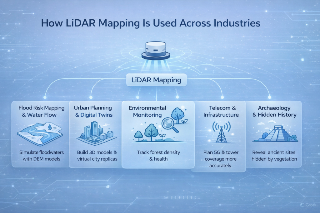
So, How Is It Used?
You’d be surprised how many industries rely on LiDAR mapping today. It’s not just researchers and GIS professionals anymore.
Flood Risk Mapping and Water Flow
Flood models depend on understanding how water moves across land. With a high-resolution DEM from LiDAR, analysts can simulate how floodwaters would behave during a storm. However, DEMs need manual tweaking – for example, to account for culverts under roads, which LiDAR can’t see because it doesn’t penetrate the ground.
Urban Planning and Digital Twins
City planners use LiDAR to build detailed 3D models of urban environments. These models feed into “digital twins” – virtual versions of cities used for planning and scenario testing. Want to see how sunlight hits a new skyscraper? LiDAR data can simulate it.
Environmental Monitoring
In forestry and conservation, LiDAR is used to:
- Estimate tree density and canopy height.
- Detect signs of degradation or deforestation.
- Monitor forest health over time.
Telecom and Infrastructure
In telecoms, LiDAR helps with line-of-sight analysis for 5G and tower planning. Engineers can map out terrain and obstacles that affect signal strength, making coverage planning far more accurate.
Archaeology and Hidden History
LiDAR is excellent at seeing through vegetation. That makes it ideal for uncovering ancient settlements hidden under jungle canopies. A famous case in the U.S. used LiDAR to pinpoint the location of a prehistoric landslide referenced in Native American oral history.
LiDAR’s Strengths in a Nutshell
Here’s what makes LiDAR such a valuable tool:
- High accuracy: Down to centimeters or even millimeters.
- 3D detail: Not just shapes, but depth and elevation.
- Multiple returns: One pulse can reflect off treetops, branches, and ground, all at once.
- Works in low light: Doesn’t need sunlight like optical imagery.
- Dense point clouds: Captures data at very high resolution.
But It’s Not All Perfect
LiDAR has its trade-offs. Despite the high detail, there are a few limitations to keep in mind:
- Cost: A full LiDAR survey can cost millions, especially when mapping large or remote regions.
- Complexity: Processing LiDAR data requires powerful computers and trained analysts.
- Not real-time: It’s not a live feed. If terrain changes, the map needs to be redone.
- Water issues: LiDAR doesn’t work well through water unless specialized bathymetric systems are used.
As of 2023, only about 5% of Earth’s surface has been mapped using LiDAR. That’s partly due to the high cost and the sheer effort involved.
Beyond LiDAR: When It’s Just Part of the Puzzle
LiDAR is rarely used in isolation anymore. In modern geospatial workflows, it’s often fused with other data sources:
- Satellite imagery provides texture and color.
- Photogrammetry helps fill in missing visuals.
- GIS layers add things like roads, population, or land use.
This layered approach creates highly realistic 3D environments. For example, combining LiDAR elevation with a satellite image of a village gives both structural depth and visual detail. The result feels more like a digital replica of the real world.
How We Approach Geospatial Mapping at FlyPix AI
At FlyPix AI, we focus on automating geospatial analysis using artificial intelligence. Our platform helps users quickly detect and label objects in satellite, drone, and aerial imagery, even in scenes that are dense, complex, or difficult to process manually. While LiDAR mapping offers detailed elevation data, our work complements it by delivering fast, scalable object-level insights from the visual layer.
In real-world projects, our users often pair different types of geospatial data to get a more complete picture – for example, using high-resolution imagery with structural mapping or land classification. That’s where we come in. With FlyPix, teams can go from raw images to actionable insights in minutes, whether they’re monitoring infrastructure, tracking environmental changes, or inspecting large sites. We bring the speed and flexibility needed to scale visual mapping workflows without sacrificing accuracy.
LiDAR for the Future
We’re seeing LiDAR being adopted more in AI-powered systems too. Platforms like FlyPix AI use image recognition and geospatial data together to automate inspections, land-use classification, and even environmental cleanups. In these systems, LiDAR is often part of a broader “geospatial intelligence” stack, helping machines understand physical space more like humans do.
The next frontier? Continuous topographic-bathymetric LiDAR that maps both land and shallow seafloor in one sweep. These systems can support coastal flood models, monitor erosion, and simulate wave behavior near shorelines.

When Is LiDAR the Right Tool?
LiDAR makes the most sense when:
- You need highly accurate 3D elevation data.
- Your area is covered by trees or buildings.
- You’re modeling floods, forests, or terrain.
- You need to plan infrastructure or simulate environments.
It’s overkill for basic mapping or casual visualizations. But if precision matters, and it often does, LiDAR is hard to beat.
Final Thoughts
LiDAR mapping isn’t just a niche technology anymore. It’s one of the most accurate and versatile tools we have for measuring and modeling the world. While it does come with a cost, it offers an unmatched level of detail that other methods simply can’t match on their own.
As tools become more accessible and AI continues to automate the hardest parts of processing, expect LiDAR to play a bigger role in everyday analysis – from government planning to smart agriculture and beyond.
If we want better decisions about the planet, we need better data about it. LiDAR is how we get there.
FAQ
It’s not always “better” – just different. Satellite images show what things look like. LiDAR shows you how high they are and exactly where they sit in space. If you care about elevation, structure, or terrain details, LiDAR wins hands down. But combine the two, and you’ve got a much stronger picture.
Not through buildings, no. But it can penetrate gaps in tree canopies. So while it won’t magically see everything below a forest, it often gets enough data to model the ground underneath pretty well. That’s why it’s so valuable in forestry and archaeology.
Most of the time, yes. Airborne LiDAR from planes or drones is the go-to for big areas. But there are also ground-based LiDAR systems (called terrestrial LiDAR) and even mobile ones mounted on vehicles. Some satellites carry LiDAR, but they’re the exception.
It’s a mix of hardware, flight time, and post-processing. You’re paying for lasers, GPS, onboard sensors, and then people who know how to turn raw data into something useful. The result is super detailed, but yeah – it’s not cheap.
Depends on how much the area changes. A forest might only need scanning every few years. A fast-growing city? Probably more often. If you’re using LiDAR for planning or risk assessment, having up-to-date data makes a big difference.
You can, especially if you’re using tools that handle the heavy lifting for you. Platforms like FlyPix AI, for example, focus on making geospatial analysis faster and easier, even for teams that don’t have GIS specialists on staff.
Absolutely. It’s used for flood modeling, landslide risk, coastal erosion, wildfire zones – the list goes on. If the landscape plays a role in the risk, LiDAR helps model that with way more accuracy than older methods.