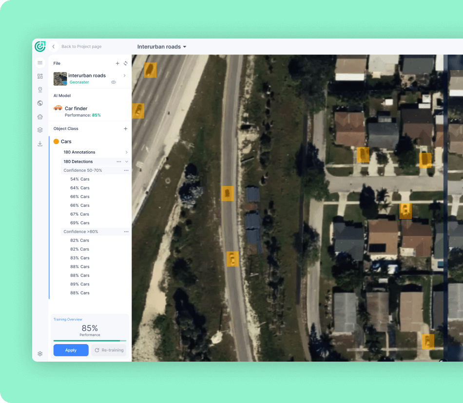
An end-to-end geospatial AI platform 

for object detection, localization, tracking, and monitoring

FlyPix AI GIS platform

With FlyPix's AI engine, you can extract geo-referenced insights from geospatial imagery in an automated and user-friendly way

What can FlyPix do for you?

Con-icon-01

Detect, segment and localize objects and areas

  • By accessing and selecting existing AI models from FlyPix's library
  • By creating and improving your own model in an intuitive way
Con-icon-02

Get detailed information about an object's properties

  • Object type
  • Area
  • Size
  • Other
Con-icon-03

Change detection

Monitor how a particular area has changed over time

Con-icon-04

Anomaly detection

Quickly identify unusual patterns in aerial imaging

Con-icon-05

Tracking over time

Detect and track changes in an object's properties or location over time

Con-icon-06

Create use cases tailored to your needs

How does FlyPix work?

FlyPix AI 03
flypix ai logo

Benefits

Save time and money

With FlyPix AI you can leverage the power of
AI to conduct remote inspections from the
comfort of your desk

Gain competitive edge

Our cutting-edge deep learning technology
equips you with a quick and powerful way of
extracting insights.

Best-in-class user experience

FlyPix AI's user friendly interface allows you
to visualize geospatial data in a simple way
and extract reports in a variety of formats

The industries we serve

Government

Waste and Debris Detection
Detect and classify different types of waste such as construction debris, hazardous waste, electronic waste and other types of garbage

Road and Pavement Inspections
Detect and classify cracks, potholes and other types of road damage to prioritize repairs and maintenance

Construction

Construction Site Inspection
FlyPix's object detection technology for aerial imagery allows construction supervisors to conduct site inspections and monitor progress remotely while reducing the need for on-site inspections and improving security

Renewable energy

Monitoring of Critical Infrastructure
Monitor critical infrastructure such as solar panels and wind turbines in areas expanding thousands of kilometers in a timely manner and promptly detect anomalies or defects on the structures

Agriculture & Farming

Crop Scouting
Monitor crops, detect abnormalities in crop growth patterns, identify potential disease or pest outbreaks, and obtain valuable insights to optimize yields and reduce crop loss

Crop Disease Detection and Weed Mapping
Map weed growth and identify potential pest outbreaks to target your weed management efforts

Livestock Management
Monitor livestock and grazing patterns of herds to optimize livestock management

Risk Management

Rooftop inspections
Conduct remote assessments of rooftops conditions, detect different roof materials and identify areas of damage or deterioration

Household risk assessment
Rapidly assess the risks associated with natural disasters such as floods, wildfires, and hurricanes to accurately calculate the correct premium for an insured household.


Oil & Gas

Oil spill detection
Identify and respond to oil spills quickly, reducing environmental damage and minimising cleanup costs

Monitoring Of Oil & Gas Infrastructure
Monitor critical infrastructure such as dams and pipelines remotely to detect unannounced construction and excavation sites, or other hazards

Forestry & Ecotechnology

Tree counting & classification
Locate, count, and classify trees in a given area. 

Illegal logging & Deforestation Monitoring 
Detect and track changes in the forest canopy that may indicate the presence of illegal logging activities or deforestation.

Waste Detection and Classification
Detect and classify waste materials, such as plastics, debris, or other pollutants, spread across large areas quickly and accurately. 

Oil Spill Detection and Monitoring
Detect oil spills and obtain critical information such as the location, size, and direction of the spill.

Smart City

Smart Urban Planning
Make informed decisions about land use, infrastructure development, and transportation planning

Waste Detection & Management
Develop more effective waste management strategies, reduce environmental pollution, and improve public health and safety

Construction Debris Detection
Detect and identify various types of waste, including construction debris from high-resolution aerial imagery

Port operations

Port & Harbor Monitoring
Conduct efficient and accurate monitoring of port infrastructure and activities to improve safety, reduce downtime, and optimize operations

Mining

Haul Road Monitoring & Maintenance
Improve safety, reduce downtime, and optimize maintenance by conducting efficient and accurate monitoring of haul road conditions

Open-pit mine monitoring
Obtain insights into mine conditions to optimize operations and allocate resources more effectively

Our blog & latest news

Contact Us & Book a Live Demo

Geospatial analytics software FlyPix AI provides easy integration to existing GIS platforms. Contact us to learn more.

    Name*

    Email*

    Company

    Message (optional)