
")
Quick Summary: The 2-0 LCA Land Use Change tool is a sophisticated model designed to integrate the environmental impacts of both direct and indirect land use change (iLUC) into Life Cycle Assessments. Developed with over 15 years of research, it provides a science-based, consequential methodology to help businesses and policymakers understand the full carbon footprint and biodiversity effects of their activities, moving beyond simple emissions accounting to reveal hidden trade-offs in the supply chain.
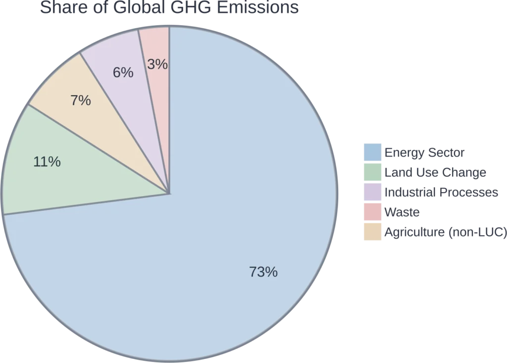
Understanding the full environmental impact of a product is more than just measuring factory emissions. Land use is a massive piece of the puzzle, accounting for about 11% of global greenhouse gas emissions. But not all impacts are obvious. That’s where the complexities of land use change (LUC) and life cycle assessment (LCA) come into play, and it’s where specialized tools become essential.
The 2-0 LCA Land Use Change tool is built to tackle this very challenge. It’s not just another carbon calculator. It’s a framework designed to uncover the hidden, indirect consequences of land use decisions.
What is the 2-0 LCA Land Use Change Tool?
At its core, the 2-0 LCA tool is an advanced model for quantifying the environmental effects of land use within a Life Cycle Assessment. Its primary differentiator is its focus on a consequential LCA methodology. This approach moves beyond a simple accounting of direct impacts to model the cause-and-effect relationships that ripple through global markets.
The key challenge it addresses is indirect land use change, or iLUC. Think about it. If you convert a field from growing food crops to growing biofuel feedstock, the global demand for that food doesn’t just disappear. Somewhere else, a forest or grassland might be cleared to make up for the shortfall. That’s iLUC, and its climate and biodiversity impacts are often completely missed in standard assessments.
The 2-0 LCA model was developed through the iLUC Club, a research community founded in 2011 with over 20 universities and companies as members, to create a generic, science-based model for this exact problem. It’s designed to be applicable to all crops, land types, and regions worldwide.
Key Features and Methodology Highlights
The 2-0 LCA tool isn’t a simple, standalone piece of software but a robust methodological framework supported by extensive data and expertise. Here’s what makes it stand out.
Consequential vs. Attributional LCA
Many LCA tools use an attributional approach, which essentially divides up the environmental burdens of the past. The 2-0 LCA model uses a consequential approach, focusing on how decisions affect the future. It asks, “What are the environmental consequences of this choice, compared to doing nothing?” This is critical for accurate decision-making.
| Approach | Focus | Primary Question Answered | Best For |
|---|---|---|---|
| Attributional LCA | Describing the past | What is the environmental footprint of X? | Reporting & Benchmarking |
| Consequential LCA | Modeling future outcomes | What are the consequences of choosing X over Y? | Decision-Making & Policy Support |
Comprehensive Scope
The model is designed for universal application. It’s not limited to specific biofuels or regions but can be applied to any land-using activity. This includes:
- Crop cultivation
- Forestry and timber
- Cattle grazing and grasslands
- Land for buildings and infrastructure
Focus on Cause-and-Effect
Instead of relying on arbitrary allocation or amortization of historical impacts, the tool models direct cause-and-effect chains. It looks at the marginal impacts of land demand, providing a much clearer picture of responsibility. This helps avoid the carbon tunnel vision that can plague simpler assessments.

Use FlyPix AI for Land Use Change Mapping
Land use change analysis needs clear geospatial data before it can support reliable LCA review, monitoring, or reporting. FlyPix AI supports geospatial image analysis for teams working with land use change, land cover monitoring, and environmental review tasks. The platform can process satellite, drone, aerial, LiDAR, SAR, and multispectral imagery, helping users detect, segment, and classify objects or areas in geospatial data.
In LCA-related land use work, FlyPix AI can support tasks such as:
- Land cover classification from geospatial imagery
- Change detection across different time periods
- Object detection and area segmentation
- Custom AI model training for specific project needs
- Geospatial data sourcing and preparation
- Exportable results for further analysis and reporting
FlyPix AI is useful when a project needs more than a manual map review, especially when large areas, repeated monitoring, or custom classification tasks are involved.
Reach out to FlyPix AI to plan a land use change mapping workflow around your project data.
Why Is Accounting for iLUC So Important?
The short answer? Because ignoring it leads to misleading results. A product might look sustainable on paper if its direct footprint is low, but if its production inadvertently causes deforestation on the other side of the world, the net effect can be hugely negative. Land use change is a primary driver of biodiversity loss and a significant source of emissions.
Failing to account for iLUC means you’re not seeing the whole picture. It’s like balancing a checkbook by only looking at the withdrawals and ignoring all the credit card debt. Companies like Maersk have used the 2-0 LCA tool to understand the trade-offs of biofuels, including impacts on land-use changes and biodiversity, to enable a more sustainable energy transition.
Real-World Applications & Services
2-0 LCA doesn’t just offer a model; it provides consulting services to help organizations implement it. They work with companies and policymakers to integrate these complex assessments into their decision-making processes.
Their work spans numerous sectors, with cases involving:
- Food and Agriculture: Developing tools for Arla Foods to calculate the carbon footprint of dairy farming across nearly 8,000 farms.
- Energy and Biofuels: Helping logistics giant Maersk evaluate the true impact of alternative fuels.
- Policy Support: Providing data and analysis to guide sustainable policy-making.
Limitations and Considerations
No model is perfect. The main challenge with any consequential LCA, including the 2-0 model, is the complexity and uncertainty involved in modeling global market dynamics. The data inputs are vast, relying on global land use matrices and satellite data, and the resulting models are inherently complex.
However, the 2-0 LCA model has been compared favorably to other iLUC models in scientific papers, where it was ranked highly for its performance across several criteria. It represents a rigorous, science-based attempt to solve a notoriously difficult problem in sustainability assessment.
Frequently Asked Questions (FAQ)
Direct Land Use Change (dLUC) happens on the specific plot of land being used (e.g., changes in soil carbon from a new farming practice). Indirect Land Use Change (iLUC) is the ripple effect, where that land use decision causes land to be converted elsewhere in the world to meet displaced demand.
Clients range from major global food industries and energy companies to universities and policymakers who need to understand the full environmental consequences of their actions.
It’s more of a methodology and data framework than a simple software tool. Access to the model and its data is typically part of a partnership or membership in the iLUC Club, or through 2-0 LCA’s consulting services.
The model is designed to be applicable to all land types, including forest land, cropland, grasslands, and even land used for buildings or infrastructure.
A consequential LCA models the future outcomes of a choice, directly comparing the environmental impact of different options. This provides actionable insight, whereas an attributional LCA simply describes the impacts of an existing system.