

Quick Summary: AgrisatWebGIS is a web-based precision agriculture platform that provides satellite imagery analysis, NDVI mapping, and field monitoring tools to help farmers optimize crop management. The tool offers multi-temporal vegetation indices, weather data integration, and user-friendly interfaces for agricultural decision-making without requiring advanced GIS expertise.
Precision agriculture has moved from research labs into real-world farming operations faster than most people anticipated. Farmers now expect tools that translate satellite data into actionable insights without demanding GIS expertise or expensive hardware.
This review digs into what AgrisatWebGIS actually offers, how it compares to alternatives, and whether it’s worth considering for your agricultural monitoring needs.
What Is AgrisatWebGIS?
AgriSat (developed by Agrisat Iberia) is a platform and consultancy framework, while the specific web-GIS software tool traditionally developed and utilized for these precise browser-based satellite analytics is called SPIDER WebGIS (or SPIDER-As).
The tool focuses on vegetation monitoring through indices like NDVI, field-level analytics, and temporal comparisons that help identify crop stress, variability, and growth patterns. That matters when agronomists need quick field assessments or when extension services work with farmers who lack technical infrastructure.
Users can define field boundaries, track changes across growing seasons, and generate reports for specific management zones.
Core Features and Capabilities
AgrisatWebGIS centers on a handful of key functions that address common precision agriculture workflows.
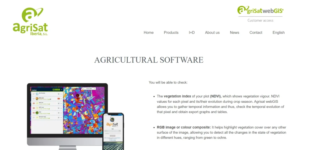
NDVI and Vegetation Index Mapping
The normalized difference vegetation index remains the workhorse of remote sensing agriculture, and AgrisatWebGIS makes it straightforward to access. The platform calculates NDVI from satellite imagery and displays results as color-coded maps showing vegetation vigor across fields.
Beyond basic NDVI, the tool typically provides access to related indices—EVI (Enhanced Vegetation Index), SAVI (Soil-Adjusted Vegetation Index), and others that account for different crop types, soil backgrounds, and atmospheric conditions.
Multi-temporal analysis lets users compare the same field across dates. That’s where patterns emerge: areas consistently showing lower vigor might indicate soil compaction, drainage issues, or pest pressure that single-date snapshots miss.
Field Boundary Management
Before any analysis happens, fields need definition. AgrisatWebGIS allows users to draw polygons directly on satellite base maps or import existing boundary files. Once defined, those boundaries become reusable across seasons and analysis types.
This might sound trivial, but field management becomes the organizational backbone when monitoring dozens or hundreds of parcels. Good boundary tools separate useful platforms from frustrating ones.
Weather Data Integration
Vegetation indices tell part of the story. Weather data completes it. AgrisatWebGIS integrates meteorological information—rainfall, temperature, humidity—so users can correlate crop stress with environmental conditions.
Did that NDVI drop correspond with a dry spell? Or did it happen despite adequate rainfall, suggesting disease or nutrient deficiency? Context matters for correct interpretation.
Time-Series Analysis
Single-date imagery provides a snapshot. Time-series analysis reveals trends. AgrisatWebGIS tracks vegetation indices across the growing season, charting how individual fields or management zones progress compared to historical patterns or neighboring areas.
This temporal dimension supports both reactive management (identifying current problems) and preventive strategies (spotting early decline before visual symptoms appear).
User Interface and Accessibility
Technical capability means nothing if users can’t navigate the interface. AgrisatWebGIS emphasizes simplicity, which cuts both ways.
The web interface loads quickly and presents maps with familiar zoom and pan controls. Toolbars remain uncluttered, with primary functions accessible through clear icons. For users accustomed to consumer map applications, the learning curve stays shallow.
That simplicity does impose limitations. Advanced GIS users might find themselves missing layer control granularity, custom symbology options, or sophisticated spatial analysis tools available in platforms like QGIS or ArcGIS. AgrisatWebGIS trades power for approachability.
The platform works across devices—desktop browsers, tablets, even phones in a pinch. That mobility matters when agronomists need to check field data while actually standing in the field.
Data Sources and Image Resolution
Satellite imagery quality determines analysis accuracy. AgrisatWebGIS typically relies on freely available satellite programs, particularly the European Space Agency’s Sentinel-2 constellation and NASA’s Landsat series.
Sentinel-2 provides 10-meter resolution for key bands used in vegetation indices, with a revisit time of approximately five days (though actual cloud-free imagery frequency varies by location). That combination delivers detailed-enough imagery for field-scale analysis with frequent enough updates to catch rapid changes during critical growth stages.
Landsat adds a longer historical archive, valuable for multi-year comparisons and trend analysis, though at a coarser 30-meter resolution.
Some precision agriculture platforms integrate commercial high-resolution imagery (sub-meter resolution) for premium tiers. AgrisatWebGIS utilizes freely available satellite data sources, which keeps costs manageable but limits fine-detail applications.
Practical Applications in Precision Agriculture
Tools exist to solve problems. What does AgrisatWebGIS actually help farmers and agronomists accomplish?
Variable Rate Application Planning
NDVI maps showing within-field variability inform variable rate application of inputs. Areas with lower vegetation vigor might need additional nitrogen; zones with excessive growth might benefit from plant growth regulators to prevent lodging.
AgrisatWebGIS generates the spatial data needed to create management zones. Users can export these zones as shapefiles compatible with farm equipment controllers, closing the loop from observation to prescription.
Crop Stress Detection
Visual field scouting misses stress that hasn’t yet produced symptoms. Vegetation indices detect physiological changes before they become visible to the human eye.
Regular monitoring through AgrisatWebGIS can flag problem areas days or weeks ahead of when walking the field would reveal issues. That early warning window allows for timely interventions—fungicide applications, irrigation adjustments, pest management—when treatments remain effective.
Yield Prediction and Performance Analysis
Vegetation vigor throughout the season correlates with final yield. Multi-temporal NDVI data feeds into yield prediction models, helping farmers anticipate production and make marketing decisions earlier.
Post-harvest, comparing yield maps against seasonal vegetation indices identifies which field areas consistently underperform, justifying targeted soil sampling or drainage improvements.
Documentation and Compliance
Regulatory frameworks increasingly require documentation of agricultural practices. Satellite-derived records provide objective, time-stamped evidence of crop conditions and management timing.
AgrisatWebGIS archives imagery and analysis results, creating an audit trail for certification programs, subsidy compliance, or environmental reporting.
AgrisatWebGIS Compared to Alternative Platforms
The precision agriculture software landscape includes dozens of competitors. How does AgrisatWebGIS stack up?
| Platform | Primary Strength | Best For | Accessibility |
|---|---|---|---|
| AgrisatWebGIS | Simple web-based NDVI and vegetation monitoring | Users needing straightforward satellite analysis | Browser-based, no installation |
| FlyPix AI | Advanced geospatial analysis with AI-powered insights | Organizations requiring sophisticated spatial analytics | Cloud platform with trial options |
| QGIS | Full-featured open-source GIS with extensive plugins | Users comfortable with desktop GIS software | Free desktop application |
| Farmonaut | Affordable satellite monitoring with mobile apps | Small to medium farms wanting low-cost monitoring | Web and mobile apps |
| EOSDA | Comprehensive crop monitoring with AI analytics | Commercial farms and agribusinesses | Web-based SaaS platform |
Each platform makes different trade-offs between power, simplicity, and cost. AgrisatWebGIS occupies the middle ground—more capable than basic mobile apps, less complex than professional GIS software.
When AgrisatWebGIS Makes Sense
The platform fits well for agricultural consultants managing multiple client farms who need quick, repeatable analysis workflows. Extension services providing technical support to farmers benefit from the accessibility and low barrier to entry.
Medium-sized farming operations that have moved beyond simple record-keeping but aren’t ready for enterprise farm management systems find the functionality appropriate for their needs.
When to Look Elsewhere
Large agribusinesses requiring integration with existing enterprise systems might find AgrisatWebGIS too limited in API access and data export options.
Researchers conducting detailed spatial analysis need the statistical and modeling capabilities of platforms like QGIS or ArcGIS. AgrisatWebGIS handles operational monitoring better than scientific investigation.
Farms focused primarily on task management, equipment tracking, and financial record-keeping might prefer comprehensive farm management systems that include satellite monitoring as one component rather than a specialized tool.

Map Land Features with FlyPix AI
AgrisatWebGIS is connected with satellite-based agricultural mapping and GIS-style field review. FlyPix AI can add more detail to this kind of work by analyzing satellite, drone, and aerial imagery for visible objects, land areas, and changes across mapped locations.
FlyPix AI can help when agricultural mapping needs image-based analysis:
- Detecting visible field features, farm assets, roads, or boundaries
- Segmenting crop areas, vegetation zones, land, or water
- Reviewing visible changes across satellite or aerial imagery
- Training custom AI models for specific geospatial detection tasks
Reach out to FlyPix AI to explore how geospatial image analysis can support agricultural mapping work.
Pricing and Access
Pricing structures for precision agriculture tools vary wildly. Some charge per-hectare monitored, others use subscription tiers based on feature access, and a few remain fully free but limited.
Specific current pricing for AgrisatWebGIS should be verified directly with the provider, as agricultural software pricing changes frequently and may include regional variations or institutional licensing.
Generally speaking, web-based satellite monitoring platforms offer tiered plans. Entry levels typically provide basic NDVI mapping for small farm areas, while premium tiers add features like weather integration, custom reports, and historical data access for larger agricultural operations.
Many platforms provide trial periods or free tiers with limited functionality. Testing the interface and workflow with actual farm data before committing to a subscription makes sense given how much platforms differ in usability.
Technical Considerations and Limitations
No tool is perfect. Understanding limitations helps set realistic expectations.
Cloud Cover and Temporal Gaps
Optical satellite imagery can’t see through clouds. In regions with persistent cloud cover during growing seasons, gaps in data availability become frustrating.
AgrisatWebGIS relies on optical satellites (Sentinel-2, Landsat), so cloudy periods mean no new imagery. Platforms incorporating synthetic aperture radar (SAR) data can see through clouds but require more complex interpretation.
The five-day Sentinel-2 revisit doesn’t guarantee five-day updates. Cloud-free imagery might come weekly, or in some cases, every few weeks during cloudy stretches.
Resolution Constraints
Ten-meter resolution from Sentinel-2 works well for most field-scale applications but struggles with small plots or highly fragmented agricultural landscapes.
Mixed pixels along field edges, narrow strips, or small management zones produce ambiguous results. Users managing vineyards, orchards, or vegetable operations with sub-field-scale management needs might find the resolution limiting.
Interpretation Skill Requirements
While AgrisatWebGIS simplifies data access, correct interpretation still requires agricultural knowledge. An NDVI map shows patterns, but understanding why they occur and what actions to take demands agronomic expertise.
The platform provides data; it doesn’t replace the decision-making capacity of experienced farmers and agronomists. Training and gradual skill development remain necessary for effective use.
Integration with Farm Management Workflows
Precision agriculture tools generate value when they fit into existing workflows rather than demanding parallel processes.
AgrisatWebGIS supports data export in standard formats—shapefiles for GIS compatibility, CSV tables for spreadsheet analysis, and image files for reports and presentations. That flexibility helps integrate satellite-derived insights with other farm data sources.
Some farm management information systems (FMIS) offer API connections or direct integrations with monitoring platforms. Check whether AgrisatWebGIS connects with any existing software in use before committing.
The reality is that most agricultural operations still run on a patchwork of tools. As long as data can move between systems via exports and imports, perfect integration isn’t necessary for practical value.
Real-World Performance Insights
Agricultural technology lives or dies based on field performance, not specification sheets. While formal academic studies specifically evaluating AgrisatWebGIS are limited, broader research on satellite-based crop monitoring validates the underlying approach.
Precision agriculture programs at universities across Europe and North America have demonstrated that NDVI-based monitoring can identify within-field yield variation, detect nutrient stress several weeks before visual symptoms, and support variable rate nitrogen application that reduces input costs while maintaining yields.
Community discussions among agronomists and precision agriculture practitioners consistently highlight that satellite monitoring works best as part of an integrated approach. Ground-truthing satellite observations with field scouting, soil tests, and yield data produces more reliable insights than satellite imagery alone.
The accessibility and ease of use that define AgrisatWebGIS matter most for adoption. Tools that sit unused because they’re too complicated or require too much time deliver zero return regardless of their technical capabilities.
Support, Training, and Documentation
Learning curves exist for any new technology. Quality support resources determine whether users push through initial confusion or abandon tools in frustration.
Web-based platforms typically provide tutorial videos, documentation libraries, and help forums. The depth and quality of these resources vary significantly between providers.
For AgrisatWebGIS specifically, contact the provider to understand what training resources come with subscriptions. Some platforms include onboarding sessions or periodic webinars; others provide only documentation.
Community forums and user groups can be valuable for troubleshooting and learning practical tips that official documentation misses. Check whether an active user community exists around the platform.
The Bigger Picture: Precision Agriculture Adoption
Tools like AgrisatWebGIS exist within a broader shift toward data-driven agriculture. Understanding that context helps frame expectations about what any single tool can accomplish.
Precision agriculture adoption continues growing, but unevenly. Large commercial farms in developed regions lead adoption; smallholder operations and farmers in less-connected areas lag behind. Cost, complexity, and infrastructure requirements all influence who can actually implement these technologies.
Research from universities working on precision agriculture programs emphasizes that technology adoption succeeds when it solves specific, immediate problems farmers face. Abstract promises of “optimization” or “sustainability” matter less than demonstrating that a tool will reduce nitrogen costs by a quantifiable amount or catch disease outbreaks three weeks earlier.
Research on digital agriculture adoption emphasizes that the digital transition works best when research institutions, private companies, and public agricultural agencies collaborate. No single organization provides the complete solution.
Who Should Consider AgrisatWebGIS?
After examining capabilities and limitations, a clearer picture emerges of the ideal user profile.
Agricultural consultants providing crop monitoring services to multiple clients benefit from the streamlined, repeatable workflow. The browser-based access means consulting from anywhere without carrying specialized hardware or managing software installations across devices.
Mid-sized farming operations that have moved beyond basic crop management but aren’t ready for enterprise-scale farm management systems find appropriate functionality. The learning investment remains reasonable while delivering measurable value.
Extension services and agricultural education programs can use AgrisatWebGIS to introduce precision agriculture concepts without overwhelming students or farmers with GIS complexity. The accessibility lowers barriers to initial adoption and learning.
Research teams focused on operational applications rather than methodological development might find the platform sufficient for project needs, particularly when fieldwork budgets limit the frequency of ground-based monitoring.
Making the Most of Satellite Monitoring
Regardless of which platform is used, certain practices maximize the value extracted from satellite-based crop monitoring.
Regular monitoring throughout the growing season captures patterns that occasional snapshots miss. Set a weekly or bi-weekly schedule for checking imagery rather than waiting until problems become obvious.
Ground-truth satellite observations with field visits. NDVI shows where to look, but determining the actual cause of stress requires boots-on-the-ground investigation. The combination of remote sensing and targeted scouting outperforms either approach alone.
Keep records that connect satellite observations with management actions and outcomes. Did the low-vigor zone identified in June correspond with lower yields at harvest? Did the fungicide application after detecting early stress preserve yields? Building that feedback loop improves interpretation skills over time.
Integrate weather data and historical field knowledge. A veteran farmer knows that the northeast corner always drains poorly or the south field has sandier soil. Combining local knowledge with satellite data produces insights neither source alone provides.
Frequently Asked Questions
AgrisatWebGIS typically relies on freely available satellite programs, primarily the European Space Agency’s Sentinel-2 constellation and NASA’s Landsat series. Sentinel-2 provides 10-meter resolution imagery with approximately five-day revisit times, suitable for field-scale agricultural monitoring. This approach keeps costs manageable while providing adequate detail for most precision agriculture applications.
The web-based platform functions across devices including desktop computers, tablets, and smartphones. The interface adapts to different screen sizes, allowing agronomists to check field data while actually in the field. However, detailed analysis and report generation work more efficiently on larger screens. Mobile access serves best for quick checks and field verification rather than comprehensive analysis sessions.
Optical satellites can’t see through clouds, so cloudy weather creates gaps in imagery availability. While Sentinel-2’s five-day revisit schedule suggests frequent updates, actual cloud-free imagery for a specific field might arrive weekly or even less frequently during persistently cloudy periods. Regions with frequent cloud cover during growing seasons may experience frustrating data gaps that limit monitoring consistency.
AgrisatWebGIS emphasizes accessibility over complexity, making it more approachable than traditional GIS software. Users familiar with web mapping tools like Google Maps typically navigate the basic functions within hours. Understanding how to interpret vegetation indices and apply insights to agronomic decisions takes longer—usually several weeks of regular use combined with field experience. The technical interface is straightforward; the agricultural interpretation requires domain knowledge.
Aerial imagery services (manned aircraft or drones) provide higher resolution and on-demand timing but cost significantly more per flight. Satellite-based monitoring through AgrisatWebGIS offers lower resolution but free imagery acquisition and historical data access. For routine seasonal monitoring across many fields, satellite platforms prove more cost-effective. For detailed problem investigation or sub-field precision, aerial services deliver superior detail. Many operations use both strategically.
The platform typically supports exporting management zones and analysis results as shapefiles compatible with farm equipment controllers. This allows prescription maps created from NDVI analysis to guide variable rate application equipment. However, direct integration varies by equipment brand and controller generation. Check compatibility with specific machinery before assuming seamless workflows. Manual export and import steps remain common.
Satellite monitoring applies equally to organic and conventional systems. NDVI and vegetation indices detect crop stress, variability, and growth patterns regardless of management approach. Organic operations can use the platform to optimize organic fertilizer application timing, identify areas needing additional compost, or detect pest and disease pressure early enough for organic intervention methods. The monitoring technology itself remains neutral to farming philosophy.
Conclusion: Finding the Right Fit
AgrisatWebGIS occupies a practical niche in the precision agriculture landscape. It won’t replace comprehensive farm management systems for large agribusinesses, and it can’t match the analytical power of professional GIS software. But those aren’t its goals.
The platform delivers accessible, straightforward satellite-based crop monitoring to users who need actionable information without drowning in complexity. For consultants, educators, extension specialists, and progressive farmers looking to move beyond reactive management, it provides the core functionality that drives better decisions.
Limitations exist—cloud cover frustrations, resolution constraints for small plots, and interpretation skill requirements don’t disappear. But perfect tools don’t exist. The question isn’t whether AgrisatWebGIS handles every conceivable use case, but whether it handles your specific needs better than alternatives.
Testing the platform with actual farm data during a trial period provides the clearest answer. Satellite monitoring has moved from cutting-edge research to practical farming tool. Whether AgrisatWebGIS fits your operation depends on matching its strengths to your priorities.
For those seeking approachable entry into precision agriculture or streamlined satellite monitoring workflows, AgrisatWebGIS deserves serious consideration. Check current pricing and feature availability directly with the provider, then test whether the workflow fits your agricultural decision-making process.
The digital transition in agriculture continues accelerating. Tools that lower barriers while delivering real value will drive adoption more effectively than technically impressive but inaccessible platforms. AgrisatWebGIS aims for that accessible effectiveness—whether it succeeds for your operation comes down to testing it against your actual needs.