
Quick Summary: AGROMIX LUCIM (Land Use Change Interactive Map) is an online interactive mapping tool developed as part of the AGROMIX project. It helps identify European target areas where agroforestry and mixed farming systems can be implemented to increase environmental resilience and support climate change mitigation and adaptation strategies.
Land use change tools have become essential infrastructure for anyone working in sustainable agriculture, urban planning, or environmental policy. The challenge isn’t finding tools anymore—it’s finding tools built specifically for the complexities of modern agroforestry and mixed farming systems.
That’s where AGROMIX LUCIM enters the picture.
Unlike general-purpose GIS platforms or broad environmental monitoring systems, LUCIM was designed from the ground up to address a specific gap: identifying priority areas and providing spatial + expert-informed insights for transitioning to agroforestry and mixed agricultural systems.
This review breaks down what LUCIM actually does, who it’s built for, and how it stacks up against other land use change tools in the current market.
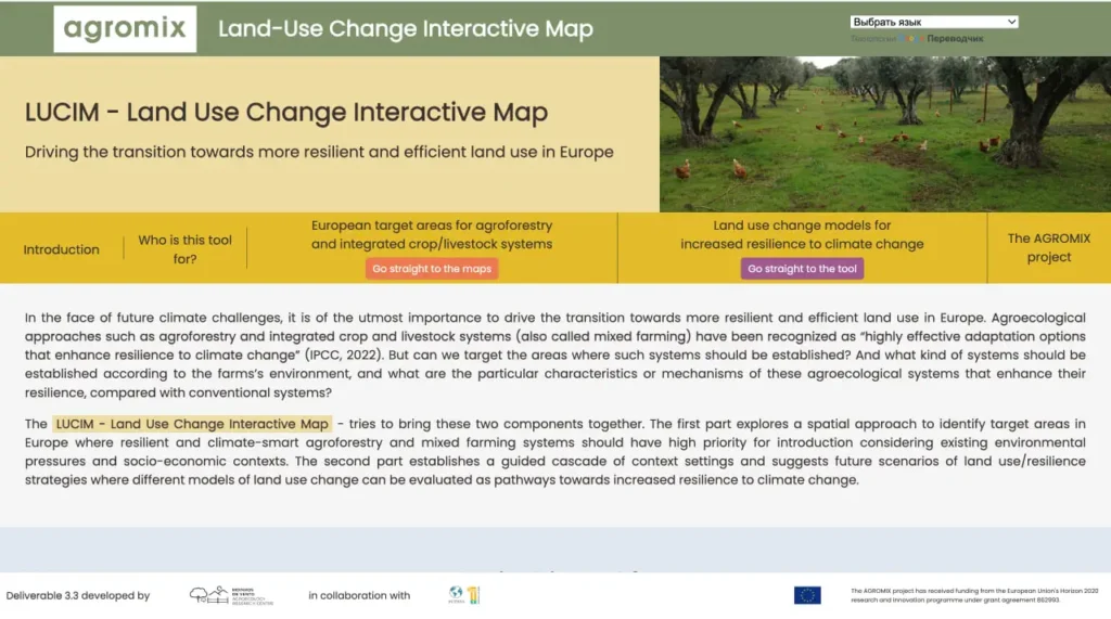
What Is AGROMIX LUCIM?
AGROMIX LUCIM stands for Land Use Change Interactive Map. It is an online interactive mapping tool that identifies European target areas where agroforestry and mixed farming systems can be implemented to increase environmental resilience.
At its core, LUCIM combines spatial analysis of environmental, climate, and socio-economic factors with insights from a Delphi expert study. The tool allows users to explore different combinations of criteria and visualize priority zones for transitioning to more resilient agricultural systems.
Development Background
LUCIM emerged from the broader AGROMIX project, a European research initiative examining sustainable intensification through agroforestry. The project brought together agronomists, ecologists, spatial analysts, and policy researchers.
The team developed LUCIM to fill a specific gap: providing clear spatial context and expert-informed insights to help identify where agroforestry and mixed farming systems can best contribute to climate resilience across Europe.
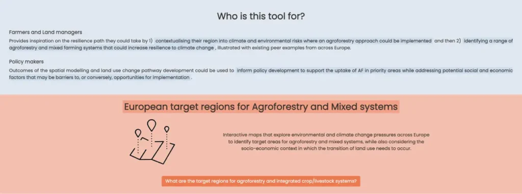
Primary Use Cases
LUCIM serves several distinct user groups:
- Agricultural researchers studying spatial patterns and potential for farming system transitions
- Policy analysts evaluating land use regulations and incentive programs
- Regional planners developing sustainable land management strategies
- Environmental consultants identifying suitable areas for agroforestry projects
- Farm advisors and extension services exploring regional opportunities for mixed systems
The platform is best suited for strategic and regional-level analysis. It assumes users have basic familiarity with land use planning and environmental issues.
Core Features and Capabilities
LUCIM’s feature set focuses on its core purpose as an interactive mapping and decision-support tool rather than a general-purpose GIS platform.
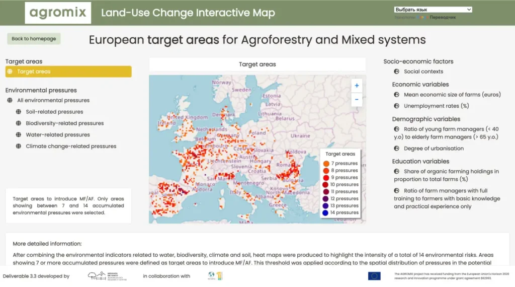
Interactive Mapping and Spatial Analysis
The main functionality of LUCIM is to visualize priority areas across Europe for agroforestry and mixed farming implementation. Users can explore maps that highlight regions with high environmental pressures (such as water scarcity, soil erosion, or biodiversity loss) combined with socio-economic context.
Delphi-Based Resilience Insights
The tool incorporates results from a comprehensive Delphi study involving experts, providing consensus-based pathways and resilience strategies for different land use transitions under climate change scenarios.
Visualization and Exploration
Users can filter and combine data layers to generate custom views of potential target areas and better understand where interventions may have the greatest impact.
How LUCIM Compares to Other Land Use Change Tools
Understanding LUCIM’s position in the broader landscape of land use change tools requires looking at what alternatives exist and where they excel versus where they fall short for agroforestry-specific applications.
General GIS Platforms vs. Specialized Tools
Platforms like ArcGIS Pro and QGIS offer comprehensive geospatial analysis capabilities. They handle land use change detection, spatial modeling, and environmental assessment workflows. Their flexibility makes them powerful for diverse applications.
But that flexibility comes with complexity. Setting up an agroforestry impact assessment in a general GIS requires assembling multiple extensions, configuring custom analysis workflows, and often writing scripts to handle specialized calculations. The user needs both GIS expertise and domain knowledge about agroforestry systems.
LUCIM offers a more focused and accessible approach for its specific purpose. Instead of requiring users to build complex custom workflows, it provides ready-made maps and expert-informed insights focused on agroforestry priority zones in Europe. This makes it faster to get strategic insights for teams working in this domain.
Satellite-Based Monitoring Platforms
Tools like FlyPix AI and Google Earth Engine excel at processing satellite imagery to detect land cover changes at scale. These platforms can monitor millions of hectares, identify deforestation events, track urban expansion, and quantify agricultural intensification.
According to Flypix, their solutions “save time and resources while delivering precise, actionable geospatial analysis” to address land use change challenges. That precision matters when tracking macro-level changes across large regions.
LUCIM approaches the problem differently. Rather than focusing on detection and monitoring of past or current changes, the tool emphasizes forward-looking identification of priority areas and resilience insights based on spatial analysis and expert consensus.
Academic Research Tools
Several land use change modeling platforms originated in academic research contexts. Land Change Modeler, for example, provides sophisticated algorithms for projecting future land use patterns based on historical trends and driving variables.
These tools often require significant technical expertise and substantial data preparation. They’re powerful for research applications but can be challenging to deploy in operational planning contexts where timelines are shorter and technical capacity varies.
LUCIM aims for a middle ground: rigorous enough for research applications but accessible enough for planning practitioners. The interface assumes some technical knowledge but doesn’t require programming skills or advanced spatial statistics expertise.
| Tool Category | Primary Strength | LUCIM Advantage |
| General GIS Platforms | High flexibility and custom analysis | Ready-made focus on agroforestry priority zones in Europe |
| Satellite Monitoring | Real-time change detection | Complements with forward-looking priority mapping and resilience insights |
| Academic Models | Sophisticated projection algorithms | More accessible interactive interface for exploring target areas and expert scenarios |
Map Land Use Change with FlyPix AI
Land use change tools depend on clear spatial evidence when teams review how landscapes shift over time. FlyPix AI processes satellite, drone, aerial, LiDAR, SAR, and multispectral imagery for geospatial detection, segmentation, classification, and change monitoring. For issues connected to AGROMIX LUCIM, it can support image-based review of land cover, agroforestry areas, mixed-use agricultural landscapes, and visible changes across selected regions.
Turn to FlyPix AI for:
- Land cover classification from geospatial imagery
- Detection of visible landscape features
- Area segmentation for agricultural and mixed-use land
- Custom AI model training for specific land use categories
👉Get in touch with FlyPix AI to discuss land use change mapping for your geospatial dataset.
Practical LUCIM Applications and Use Cases
The real test of any specialized tool comes down to practical application. Where does LUCIM actually get deployed, and what problems does it solve?
Regional Agricultural Planning
Regional planning authorities use LUCIM to identify priority zones where agroforestry and mixed systems can deliver the greatest resilience benefits. Planners can explore different combinations of environmental risks and socio-economic factors to better target incentives and policy measures.
Farm-Level Transition Planning
Agricultural extension services and cooperatives can use LUCIM to understand regional opportunities and help farmers consider the broader spatial context when planning transitions to mixed systems.
Environmental Impact Assessment & Climate Mitigation Program Design
Policymakers and consultants use the tool to identify suitable areas for interventions and support evidence-based program design focused on climate adaptation and mitigation through agroforestry.
Research and Academic Applications
Researchers use LUCIM to explore spatial patterns, generate hypotheses for field studies, and support teaching about European agroforestry opportunities.
Technical Requirements and User Experience
LUCIM is a fully web-based interactive mapping tool embedded in the official AGROMIX and MVARC platforms. It runs directly in a modern web browser and does not require software installation, powerful hardware, or supercomputing resources. A stable internet connection is sufficient.
The interface is designed for researchers, planners, and policymakers with some background in environmental or agricultural topics. Training materials are available through the AGROMIX project.
Strengths and Limitations
No tool excels at everything. Understanding where LUCIM delivers strong value versus where it shows limitations helps organizations make informed decisions about when to deploy it.
Key Strengths:
- Strong specialization in agroforestry and mixed farming systems in the European context.
- Clear spatial identification of priority target areas based on multiple environmental and socio-economic layers.
- Integration of expert knowledge through the Delphi method for resilience strategies.
- Free public access as a research deliverable.
- Useful for strategic planning and policy development.
Notable Limitations:
- Primarily focused on Europe and calibrated for European agricultural systems.
- Not a dynamic scenario modeling engine for custom farm-level projections (e.g., 10–30 year carbon or economic forecasts).
- Does not perform detailed lifecycle assessment (LCA) or user-defined impact simulations.
- Best suited for strategic and regional analysis rather than operational farm-level planning.
- Requires complementary tools for real-time monitoring or highly localized detailed analysis.
Pricing and Access Considerations
LUCIM is a publicly funded research tool and is available free of charge as an online interactive map. Access is open through the official AGROMIX and MVARC websites. No commercial licensing is required, though users may benefit from contacting the development team for guidance or collaboration.
Integration with Broader Agroforestry Ecosystems
LUCIM doesn’t stand alone in the agroforestry planning and research landscape. Understanding how it connects to related platforms and initiatives provides context for where it fits in broader workflows.
AGROMIX Project Connections
LUCIM represents one component of the larger AGROMIX research ecosystem. The project includes field trial networks, farmer engagement programs, knowledge platforms, and educational resources focused on agroforestry systems.
Users working within the AGROMIX framework can draw on this broader ecosystem. Spatial insights and priority maps from LUCIM can help inform farmer support programs and policy recommendations developed through other AGROMIX work streams.
DigitAF and Agroforestry Virtual Space
The European agroforestry research community has developed several digital platforms supporting knowledge exchange and collaboration. DigitAF’s Agroforestry Virtual Space provides a dynamic platform for sharing agroforestry-related images and information.
The Agroforestry Permanent Photo Gallery allows users to upload photos directly to the EURAF Agroforestry Media Zenodo community. Each uploaded image receives a DOI and is stored under open access licenses.
These documentation and knowledge-sharing platforms complement LUCIM’s analytical capabilities. Researchers can use the gallery to document agroforestry systems they’re modeling, creating visual records that support interpretation and communication of assessment results.
Links to Policy Frameworks
LUCIM’s development connects to European agricultural and environmental policy contexts. The Common Agricultural Policy (CAP) and various environmental directives create policy drivers for agroforestry adoption.
The tool’s assessment framework aligns with metrics and indicators used in policy evaluation, making results directly relevant for policy implementation and monitoring. Planners developing regional strategies under CAP environmental schemes can use LUCIM outputs to demonstrate compliance with environmental objectives and justify incentive program designs.
Future Development Trajectory
Like any specialized research tool, LUCIM’s future development depends on continued research funding, user community needs, and evolving technical capabilities in the land use analysis space.
Potential Enhancement Areas
Several logical development directions could expand LUCIM’s capabilities and applicability:
- Geographic expansion beyond Europe with additional validation data
- Improved integration with other public spatial datasets and monitoring platforms
- Enhanced visualization options and export functions for policy documents
- Stronger links to real-world case studies from ongoing agroforestry projects
- Further refinement of resilience indicators as new data becomes available
Community-Driven Evolution
The research-based development model means LUCIM’s evolution reflects its user community’s priorities. Agricultural researchers focusing on specific questions drive feature development through their methodological needs. Policy users requesting specific reporting formats influence output capabilities.
This community-driven approach creates organic alignment between tool capabilities and real-world requirements. But it also means development priorities may not match commercial market demands in the way that venture-backed software companies respond to customer requests.
Open Science and Reproducibility
Growing emphasis on open science and reproducible research in the agricultural and environmental sciences could influence LUCIM’s development. Enhanced documentation of model assumptions, public availability of calibration datasets, and reproducibility tools would strengthen the platform’s scientific credibility.
Some land use change tools have moved toward open-source models where the underlying code is publicly available for scrutiny and extension. Whether LUCIM follows a similar path depends on decisions by the development team and funding agencies about how to balance openness with sustainability of continued development.
Getting Started with LUCIM
For organizations seriously considering LUCIM deployment, understanding the practical steps to get started helps set realistic timelines and resource expectations.
Initial Assessment
Before pursuing LUCIM access, organizations should evaluate whether the tool’s specialized focus aligns with their needs. Key questions include:
- Does the organization regularly work on European agroforestry or mixed farming strategies?
- Are the geographic contexts primarily within Europe?
- Does the organization need strategic/regional priority mapping rather than detailed farm-level simulation?
- Does the team have basic comfort with interactive web mapping tools?
- Is sufficient interest in climate resilience and spatial planning present?
If answers lean toward “no,” LUCIM may not represent the best tool choice. Organizations with occasional agroforestry assessment needs might be better served by hiring consultants already proficient with the platform rather than building internal capacity.
Establishing Contact
The AGROMIX consortium and MVARC represent primary contact points for LUCIM access. These organizations can clarify current access models, associated requirements, and whether the tool fits specific use cases.
Initial conversations should cover technical requirements, training availability, data preparation support, and timeline expectations. Understanding these practicalities upfront prevents false starts and resource waste.
Pilot Projects
Organizations new to LUCIM benefit from starting with constrained pilot projects rather than immediately deploying the tool for high-stakes planning decisions. A pilot might focus on a small geographic area or a simplified scenario comparison.
Pilot projects reveal data gaps, workflow challenges, and training needs in low-risk contexts. Lessons learned inform full-scale deployment and help organizations develop realistic cost and timeline estimates for larger applications.
Building Internal Capacity
Effective LUCIM use requires building organizational knowledge beyond just technical training. Staff need to understand:
- The meaning and limitations of the spatial priority maps
- Data quality and interpretation best practices
- Appropriate applications versus contexts where the tool should be combined with other methods
- How to communicate spatial insights to non-technical audiences
- Integration with broader planning and decision-making processes
Organizations might consider establishing internal communities of practice where LUCIM users share experiences, troubleshoot challenges, and develop institutional knowledge about effective deployment.
Frequently Asked Questions
LUCIM provides ready-to-use spatial maps and expert-informed insights specifically for agroforestry priority areas in Europe. While general GIS platforms offer maximum flexibility, they require significant effort to replicate the specialized multi-criteria analysis and Delphi-based resilience framework that LUCIM already delivers.
LUCIM’s models were developed and validated primarily using European agricultural data and agroforestry systems. Applying the tool to substantially different climatic zones or farming systems requires careful consideration. The underlying algorithms may need recalibration with local data to produce reliable projections. Organizations working outside Europe should consult with the LUCIM development team about regional applicability and whether validation data exists for their specific context. Some general spatial approaches may be transferable, but the specific priority mapping and resilience insights are calibrated for European conditions.
LUCIM is a ready-to-use interactive map. Users primarily explore pre-processed data layers. No complex custom data upload is required for basic use, although advanced users can interpret results alongside their own local datasets.
As a spatial prioritization and exploration tool based on current data and expert consensus, LUCIM reflects the inherent uncertainties of spatial analysis and expert judgment. Users should interpret the maps as decision-support information rather than precise predictions and combine them with local knowledge and other data sources.
LUCIM is a web-based mapping tool that works well alongside other platforms. Users can view its maps in parallel with data from QGIS, ArcGIS, or other GIS systems. While it does not require complex data imports for basic use, its outputs (maps and insights) can be easily incorporated into broader planning documents and workflows.
Conclusion
AGROMIX LUCIM provides a valuable specialized resource for identifying priority areas and exploring resilience strategies for agroforestry and mixed farming transitions across Europe. Its strength lies in the combination of spatial mapping and expert-informed insights rather than complex custom modeling. For organizations working on European agricultural policy, regional planning, or agroforestry research, LUCIM offers practical decision support grounded in the AGROMIX project findings. Ready to explore whether LUCIM fits your agroforestry assessment needs? Connect with the AGROMIX consortium or MVARC to discuss access options, review technical requirements, and determine if the platform’s capabilities align with your planning objectives.