
Quick Summary: AIDU intelligent detection tools are professional-grade geophysical instruments that use advanced imaging technology and AI analysis to locate groundwater and mineral deposits. The ADZN and ADMT series offer depth ranges from 200m to 3000m with multi-channel detection capabilities, automatic interpretation, and rugged field-ready designs. While these tools excel at subsurface data collection and visualization, they work best when combined with traditional exploration methods and require proper training to interpret results accurately.
Groundwater detection has evolved beyond old-school divining rods and guesswork. Modern geophysical tools now pack serious computational power, with some manufacturers adding AI-powered analysis to interpret subsurface data automatically.
AIDU, a Chinese manufacturer specializing in hydrogeophysical survey technology, launched detector models including updated versions. Their ADZN and ADMT series promise automatic imaging, intelligent analysis, and multi-channel detection at depths reaching 3000 meters.
But does the technology actually deliver? This review examines AIDU’s intelligent detection tools based on available specifications, user reports, and field application data.

What Are AIDU Intelligent Detection Tools?
AIDU manufactures specialized equipment for locating underground water, minerals, and geological features. Their product line includes groundwater detectors, mineral exploration devices, and borehole investigation instruments.
The company focuses on high-density electrical resistivity methods combined with transient electromagnetic sensing. These techniques measure how electrical current flows through different rock layers and soil types.
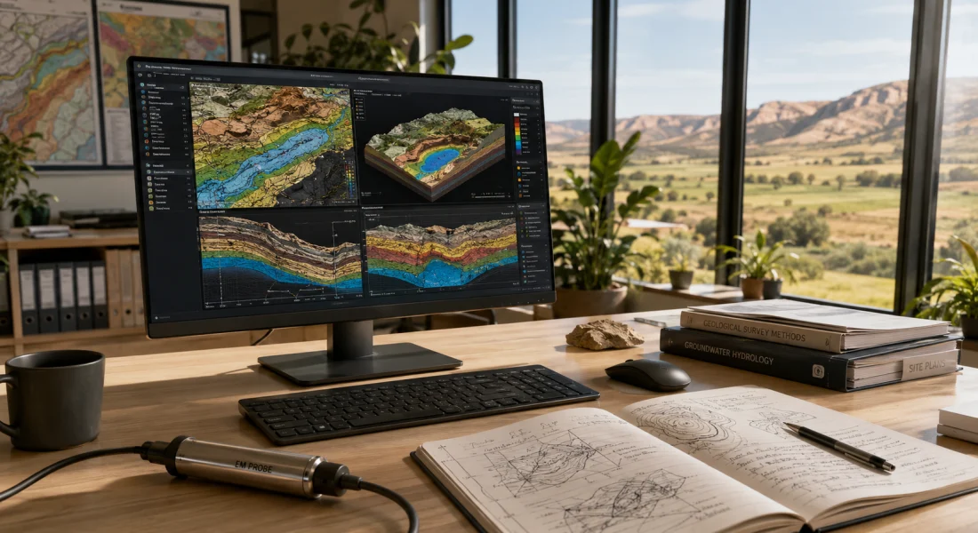
Water-bearing formations conduct electricity differently than dry rock. Mineral deposits create distinct resistivity signatures. The AIDU detectors capture these variations and convert raw voltage readings into visual maps of subsurface structure.
Core Technology: How Detection Works
AIDU devices operate using two primary geophysical methods. The MN mode measures natural field potential variations across electrode arrays. The TT mode injects controlled electromagnetic pulses and records the transient response.
Both methods collect voltage measurements at the millivolt level. The frequency range spans 0.1 to 6500 Hz, allowing detection of features at varying depths. Shallow aquifers respond at higher frequencies; deeper formations require lower frequency penetration.
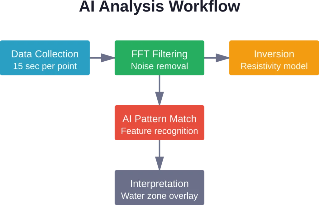
FFT smart filtering processes the raw signal, removing electrical noise from power lines, radio transmitters, and natural atmospheric interference. Discrimination precision reaches 0.01mV at ±2% accuracy according to published specifications.
Acquisition time runs 15 seconds per measurement point. For a typical survey with 30 stations along a profile line, complete data collection takes roughly 7-8 minutes.
AIDU Product Series Breakdown
AIDU offers two main detector families: the ADZN series and the ADMT series. Each targets different depth requirements and channel configurations.
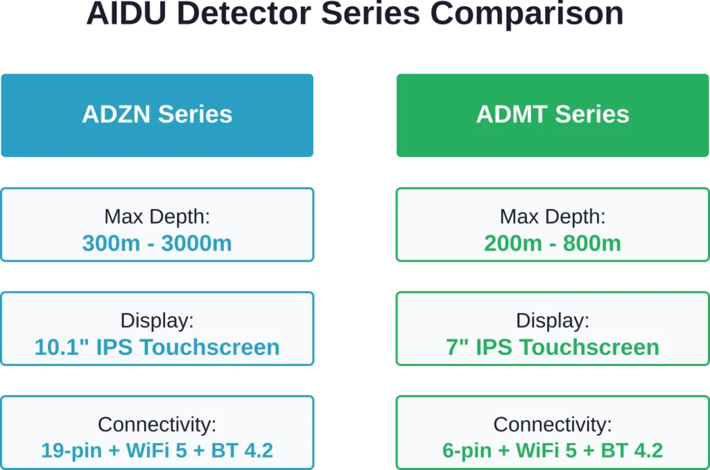
ADZN Series: Professional High-Density Detection
The ADZN line represents AIDU’s premium offering for deep exploration work. Four models cover depth ranges from 300m to 3000m:
| Model | Max Depth | Scan Interval | Channel Options |
|---|---|---|---|
| ADZN300 | ≤300m | 10m | 1-60 channels |
| ADZN600 | ≤600m | 10m | 1-60 channels |
| ADZN1200 | ≤1200m | 10m | 1-60 channels |
| ADZN3000 | ≤3000m | 10m | 1-60 channels |
All ADZN models feature a 1-60 channel integrated design standard within a single host unit. They ship with single-channel (MN) configuration by default. Multi-channel capability is achieved through optional electrode cable extensions — no external multiplexer hardware is required.
The 10.1-inch IPS touchscreen handles outdoor visibility better than earlier 7-inch displays. The resolution runs 1024×600 pixels with anti-glare coating for direct sunlight operation.
A 19-pin aviation socket connects electrode cables. The connector design resists moisture and dust ingress during field deployment. A separate 7-pin port handles charging and USB data transmission.
ADMT Series: Standard Depth Detection
The ADMT product family targets mid-range depth applications. Three configurations cover 200m to 800m investigation depths:
| Model | Max Depth | Display Size | Resolution |
|---|---|---|---|
| ADMT-200ZN | ≤200m | 7 inch | 1024×600 |
| ADMT-400ZN | ≤400m | 7 inch | 1024×600 |
| ADMT-800ZN | ≤800m | 7 inch | 1024×600 |
ADMT devices use a six-pin aviation socket compatible with both MN potential cables and TT electromagnetic sensors. The integrated charging and USB port simplifies cable management compared to separate connectors.
WiFi 5 and Bluetooth 4.2 connectivity allow wireless data transfer to tablets, phones, and laptop computers for field processing.
Automatic Imaging Capability
Here’s where things get interesting. AIDU claims their detectors produce interpretable subsurface images within five minutes of starting a survey.
Traditional geophysical surveys require trained specialists to position electrodes, collect readings, export data to desktop software, process the raw measurements, apply inversion algorithms, and finally generate cross-section plots. That workflow takes hours or days.
AIDU’s automatic imaging pipeline handles most processing steps onboard the detector itself. The device walks operators through electrode placement, automatically triggers measurements at proper intervals, and displays preliminary resistivity profiles in real-time.

The Five-Minute Setup Promise
Does it really work that fast? Sort of. The five-minute claim applies once electrodes are physically in the ground and connected.
For a basic 2D profile with 20 stations at 10-meter spacing, physical setup takes 20-30 minutes depending on terrain. Hammering stainless steel stakes into hard soil or rocky ground adds time. Running 200 meters of electrode cable through brush or across uneven topography slows things down.
Once connected though, the AIDU device does automate data collection and initial processing rapidly. The operator selects survey parameters—line length, station spacing, depth target—and the detector sequences through measurement cycles automatically.
Raw data appears on-screen during acquisition. Preliminary resistivity images generate within 2-3 minutes after the last measurement completes. That part lives up to the marketing.
AI Intelligent Analysis Features
The AI analysis component attempts to interpret resistivity patterns and highlight probable water-bearing zones or mineral anomalies automatically.
AIDU doesn’t publish detailed information about the underlying algorithms. Based on the output characteristics, the system likely uses pattern recognition trained on labeled datasets of known aquifer and mineral deposit signatures.
The detector overlays colored interpretation zones on the resistivity cross-section. Blue zones indicate probable water saturation. Red highlights suggest dry rock or air voids. Orange marks transition boundaries between distinct formations.
Accuracy of Automatic Interpretation
Real talk: automatic interpretation works reasonably well in straightforward geological settings with clear resistivity contrasts. Sand and gravel aquifers overlying crystalline bedrock show up cleanly. Shallow water tables in alluvial valleys map reliably.
Complex geology breaks the system. Interbedded clay and sand layers with similar resistivity signatures confuse the algorithm. Saline groundwater conducts electricity differently than fresh water, sometimes mimicking clay formations. Fractured rock aquifers don’t always produce recognizable patterns.
Field experience reports from practitioners highlight this limitation in complex geological settings. The AI suggestions provide a useful starting point, but experienced hydrogeologists still need to review the raw resistivity data and apply geological knowledge before drilling expensive boreholes.
NIST research from February 2026 examined LLM performance on BIG-Bench Hard and other benchmark tasks, revealing performance variation across question types. AIDU evaluation could benefit from similar structured validation frameworks.
AIDU doesn’t disclose validation datasets, accuracy metrics for different geological environments, or false-positive rates for the AI interpretation system. That lack of transparency limits confidence in automated suggestions.
Cross-Device Synchronization
WiFi connectivity enables interesting workflow capabilities. Multiple AIDU detectors deployed across a survey area can sync data to a central tablet or laptop in real-time.
For large projects covering several square kilometers, teams run parallel survey lines simultaneously. Each operator collects data with an independent detector. A project manager views incoming results from all devices on a master display, adjusting survey plans on-the-fly based on emerging patterns.
The AIDU mobile app (available for Android and iOS) displays synchronized data, manages project files, and exports results to common GIS formats including KML, Shapefile, and GeoTIFF.
Cloud Storage Integration
AIDU detectors can upload data directly to cloud storage when WiFi or cellular connectivity is available. This feature provides automatic backup and enables remote project monitoring.
Office-based geologists can review field data without waiting for teams to return from remote sites. When surveys identify promising drill targets, planning can begin immediately rather than waiting days for physical data delivery.
Data security depends on the cloud provider. AIDU supports standard services like Dropbox, Google Drive, and Chinese platforms including Baidu Cloud. Transfer encryption uses standard TLS protocols.
Rugged Design for Field Conditions
Groundwater surveys happen in dusty deserts, tropical mud, freezing mountains, and everything between. Detection equipment takes a beating.
AIDU builds their detectors into reinforced ABS plastic housings with rubber bumpers at corners and edges. The IP65 rating certifies dust-tight sealing and protection against water jets from any direction.
That doesn’t mean waterproof submersion. IP65 handles rain, splashing, and dust storms, but full immersion in water will damage the electronics. The rating is adequate for typical field conditions short of dropping the device in a river.
Operating temperature range spans -20°C to 60°C (-4°F to 140°F). Internal lithium battery packs handle cold better than older lead-acid designs. Battery life runs 8-10 hours of continuous operation depending on measurement frequency and wireless connectivity use.
Physical Portability
AIDU detector units weigh approximately 3-4 kg without electrode cables. The complete system including cables, stakes, hammers, and carrying case pushes 25-30 kg (55-65 pounds).
That’s light enough for one person to carry moderate distances, but extended hiking requires two people or pack animals. Helicopter or vehicle access to survey sites is preferable for multi-day projects.
ADMT models are similarly lightweight to ADZN units, with similar total system weights once cables are included.
Software and App Experience
A user reported challenges with the ADMT-3H model’s Android app compatibility on AliExpress.
The issue? Outdated APK files circulating through Google Play Store and third-party download sites. The solution required contacting AIDU’s vendor support directly to obtain the current firmware version V2.1.7.
After installing the updated APK file and enabling installation from unknown sources in Android settings, Bluetooth pairing worked correctly and data transfer functioned as designed.
This points to a broader pattern with specialized geophysical equipment—software updates don’t always propagate through standard app store channels. Direct manufacturer contact often proves necessary for troubleshooting and obtaining current releases.
Interface Design
The touchscreen interface uses large icons suitable for operation while wearing work gloves. Menu structure organizes functions into five main categories: survey setup, data collection, visualization, export, and settings.
Survey setup walks through a wizard-style configuration: select survey type (profile, sounding, or grid), enter line length and station spacing, choose depth target, and configure channel options.
Data collection shows real-time voltage readings with quality indicators. Poor electrode contact or excessive noise triggers warning messages. The automatic measurement sequencing works smoothly once configured.
Visualization displays raw data as pseudosections and inverted resistivity models as color-mapped cross-sections. Zooming, panning, and measurement queries work via touch gestures.
Lifetime Technical Support
AIDU advertises lifetime technical support for registered devices. Support channels include email, WeChat, WhatsApp, and phone contact with Chinese and English language options.
Response times vary. Community reports suggest 24-48 hour replies for email inquiries during Chinese business hours. WhatsApp and WeChat typically yield faster responses, sometimes within hours.
The AIDU Academy online portal provides training videos, user manuals, interpretation guides, and troubleshooting documents for registered device owners.
Physical hardware repairs require shipping devices to AIDU’s Hubei, China facility or authorized regional service centers. Turnaround time runs 2-4 weeks depending on parts availability and shipping logistics.
Comparison to Alternative Detection Tools
How do AIDU detectors stack up against competing geophysical equipment and newer AI-assisted exploration platforms?
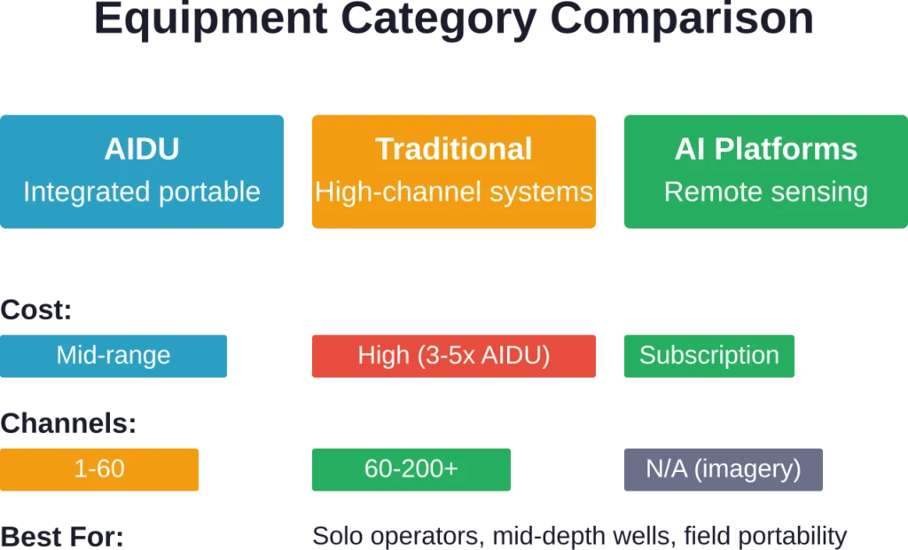
Traditional resistivity systems from manufacturers like ABEM, AGI, and Geometrics offer higher channel counts (up to 200+ electrodes), faster acquisition, and more sophisticated inversion software. But they cost 3-5 times more than comparable AIDU models and require dedicated laptop computers for operation.
AIDU’s integrated design—combining detector, display, processing, and power in a single portable unit—trades some advanced capabilities for field convenience and lower price points.
Remote Sensing AI Tools
Companies like FlyPix AI represent a different approach to subsurface investigation. Rather than placing electrodes in the ground, these platforms analyze satellite imagery, aerial photography, and geospatial datasets using machine learning algorithms.
FlyPix AI applies computer vision to identify surface features correlated with groundwater potential—vegetation patterns, geomorphology, drainage networks, and soil types. The analysis generates probability maps highlighting promising areas for detailed investigation.
This approach excels at regional-scale reconnaissance covering thousands of square kilometers. But it lacks the depth resolution and quantitative resistivity data that AIDU-type detectors provide. The tools complement each other: remote sensing narrows search areas, then ground-based geophysics pinpoints drill locations.
Detect Visible Objects with FlyPix AI
AIDU Intelligent Detection is connected with detection and inspection workflows. FlyPix AI fits this context when teams need to analyze satellite, drone, or aerial imagery to identify visible objects, separate areas, and review site conditions across larger locations.
FlyPix AI can support detection-focused geospatial work such as:
- Detecting buildings, roads, vehicles, equipment, vegetation, or other visible features
- Segmenting objects and areas within aerial or satellite imagery
- Comparing mapped locations to review visible changes
- Building custom AI models for project-specific detection needs
Contact FlyPix AI to discuss how geospatial object detection can support your inspection or monitoring workflow.
Real-World Applications and Limitations
AIDU detectors find their strongest use cases in specific scenarios: borehole siting for domestic and agricultural water wells, shallow aquifer mapping in alluvial settings, and preliminary mineral exploration reconnaissance.
These applications share common characteristics—depths under 500 meters, relatively simple geology, and tolerance for 10-20% uncertainty in target location.
What AIDU Does Well
Portable operation by a two-person field crew without requiring dedicated geophysics specialists. The automatic workflow reduces the learning curve substantially compared to traditional resistivity systems.
Rapid data turnaround enabling same-day drill site decisions. When drilling crews wait on-site, immediate detection results can adjust programs before demobilizing expensive equipment.
Multi-channel capability at moderate price points. A 12-channel ADZN600 configuration costs significantly less than equivalent Western-manufactured systems while covering most practical use cases.
Adequate depth penetration for shallow to moderate targets. The 300-800 meter range handles the majority of rural water supply applications.
Where AIDU Falls Short
AI interpretation accuracy in geologically complex terrain. The automatic analysis produces false positives and misses subtle features in fractured rock, karstic limestone, and interbedded sedimentary environments.
Channel count limitations for high-resolution 3D surveys. Modern mineral exploration increasingly demands dense 3D electrode arrays with 200+ channels. AIDU’s 60-channel maximum can’t compete.
Software sophistication compared to specialized inversion packages like Res2DInv, Res3DInv, or EarthImager. AIDU’s onboard processing produces serviceable results but lacks advanced modeling capabilities.
Service and support accessibility outside Asia. While AIDU maintains international distributors, parts availability and repair turnaround lag behind established Western manufacturers in North America and Europe.
Pricing and Value Proposition
AIDU does not publish standardized retail pricing. Costs vary by region, distributor, channel configuration, and included accessories.
For current pricing information specific to your location and project requirements, contact AIDU directly through their official website or reach out to regional distributors.
Generally speaking, AIDU detectors fall into the mid-market price bracket—more expensive than hobbyist-grade water finders but substantially less than professional survey-grade systems from major geophysical equipment manufacturers.
Value assessment depends heavily on use frequency. For geotechnical consultants running dozens of surveys annually, the equipment pays for itself within months. For occasional use—a few wells per year—rental or contracting specialized services may prove more economical.
NIST AI Evaluation Standards Context
The broader AI evaluation landscape continues evolving. NIST’s Center for AI Standards and Innovation published research in February 2026 examining statistical approaches to LLM evaluation using generalized linear mixed modeling.
While focused on language models rather than geophysical interpretation AI, the NIST AI 800-3 framework emphasizes principles applicable across AI domains: explicit disclosure of evaluation methodologies, statistical validity of accuracy claims, and transparent reporting of confidence intervals.
NIST research from February 2026 examined LLM performance on BIG-Bench Hard and other benchmark tasks, revealing performance variation across question types. That benchmark applies to well-defined logic problems, but geophysical interpretation presents murkier challenges.
Geophysical interpretation presents murkier challenges. “Correct” answers exist only after drilling confirms or refutes predictions. The lack of immediate validation feedback complicates AI training and makes accuracy claims harder to verify.
As AI-assisted tools proliferate across technical fields—mineral exploration, medical imaging, structural engineering—demand grows for standardized evaluation frameworks. NIST expanded its AI consortium scope in May 2026, renaming it the NIST AI Consortium and calling for new members with six task groups concentrating on different aspects of AI measurement science and evaluation.
AIDU and similar manufacturers would benefit from adopting structured validation protocols, publishing test results against known targets, and reporting confidence metrics alongside AI predictions. Until that transparency exists, operators should treat automatic interpretations as suggestions requiring expert review rather than definitive findings.
Frequently Asked Questions
AIDU offers models spanning 200 meters to 3000 meters maximum investigation depth. The ADMT series (ADMT-200ZN, ADMT-400ZN, ADMT-800ZN) covers 200-800m. The ADZN series (ADZN300, ADZN600, ADZN1200, ADZN3000) extends from 300m to 3000m. Actual achievable depth depends on soil resistivity, electrode spacing, and subsurface conditions.
AIDU’s AI interpretation works reliably in simple geological settings with clear resistivity contrasts—sand and gravel aquifers, shallow water tables in alluvial valleys. Complex geology with interbedded layers or fractured rock challenges the algorithm, producing both false positives and missed features. Experienced hydrogeologists should review raw resistivity data alongside AI suggestions before committing to expensive drilling. AIDU has not published validation accuracy metrics for different geological environments.
Technically possible but impractical for most surveys. The detector unit itself weighs 3-4 kg and operates easily as a single-person handheld. However, complete system setup requires deploying electrode cables spanning 100-300+ meters, hammering steel stakes every 10 meters, and connecting dozens of cables. Two-person crews work efficiently; solo operation takes 3-4 times longer and risks cable management errors.
MN mode measures natural electrical potential differences between electrode pairs, detecting variations in ground resistivity caused by water-bearing zones, mineral deposits, and geological boundaries. TT mode (transient electromagnetic) actively injects electromagnetic pulses and records the decay response, providing depth information from induced currents in conductive formations. Most surveys use MN mode; TT adds value in highly resistive environments where passive potential differences are weak.
Yes, but with limitations. AIDU devices excel at reconnaissance-level mineral exploration identifying broad anomalous zones—sulfide ore bodies, conductive clay alterations, or resistive silica caps. The technique detects electrical property contrasts, not specific minerals. Channel count limits (maximum 60) restrict high-resolution 3D surveys needed for detailed deposit characterization. Traditional mineral exploration increasingly demands 200+ channel systems that AIDU doesn’t offer. AIDU works well for initial target generation before investing in dense survey coverage.
AIDU maintains an online Academy portal with video tutorials, user manuals, and interpretation guides accessible to registered device owners. Training quality varies—basic operation instructions are comprehensive, but advanced interpretation content assumes geology background. Some regional distributors offer in-person training workshops. University geophysics programs provide broader education in electrical resistivity methods applicable to AIDU and other instruments. Manufacturers typically include 1-2 days of initial training with equipment purchase.
AIDU advertises 8-10 hours of continuous operation on a full charge. Actual battery life varies with measurement frequency, wireless connectivity use, screen brightness, and temperature. Cold conditions reduce lithium battery capacity significantly—expect 6-7 hours in freezing weather. The integrated charging port allows connection to vehicle power or portable solar panels for extended surveys. Carrying a backup USB power bank provides insurance for long field days.
Conclusion: Who Should Consider AIDU Detectors?
AIDU intelligent detection tools occupy a specific niche in the geophysical equipment market—portable, integrated systems offering good depth penetration and automatic processing at moderate prices.
The devices make sense for drilling contractors focusing on rural water well siting, agricultural consultants mapping shallow aquifers, and small-scale mineral exploration programs conducting reconnaissance surveys.
Teams requiring highest-resolution data, maximum channel counts, or cutting-edge inversion algorithms should invest in premium survey-grade systems despite higher costs.
The AI interpretation features provide value as preliminary analysis tools, not replacement for geological expertise. Smart operators treat automatic suggestions as hypotheses requiring validation through additional data and traditional interpretation methods.
Build quality and field ruggedness appear adequate for typical survey conditions. Software quirks exist—particularly around app updates and firmware compatibility—but workarounds are documented.
If your application fits the sweet spot—moderate depths, reasonable geological complexity, field portability priority—AIDU detectors deliver practical functionality at accessible price points. For current model specifications, regional availability, and pricing specific to your requirements, contact AIDU directly or consult authorized distributors in your area.
Ready to evaluate whether AIDU detection tools fit your groundwater or mineral exploration needs? Visit the official AIDU website for detailed technical specifications, download sample interpretation reports, and request demonstration equipment for field testing before committing to purchase.