
Quick Summary: Airbus Space Solutions encompasses a comprehensive portfolio of specialized software tools and platforms including DynaWorks (test data processing), SurRender (image simulation), Systema (spacecraft modeling), and OneAtlas (satellite imagery access). These tools serve aerospace engineers, defense contractors, and organizations requiring geospatial intelligence, with DynaWorks alone supporting over 5000 users worldwide and storing 20 years of test measurements for streamlined spacecraft development and validation.
Airbus Defence and Space has built an impressive ecosystem of specialized software tools that address critical challenges across spacecraft design, testing, mission simulation, and geospatial intelligence. These aren’t consumer-facing applications. They’re industrial-grade platforms used by space agencies, defense contractors, and aerospace manufacturers worldwide.
The company’s software portfolio reflects decades of operational experience. When a European space agency needs to validate vision-based navigation algorithms for a Mars lander, or when engineers must process years of vibration test data from satellite components, Airbus provides the tools that make those workflows possible.
This review examines the core platforms within Airbus Space Solutions, breaking down their capabilities, use cases, and how they fit into modern aerospace engineering workflows.
DynaWorks: Integrated Test Data Processing Platform
DynaWorks stands as Airbus’s flagship solution for test data management and analysis. Originally developed by Intespace before its absorption into Airbus Defence and Space, the platform addresses a persistent challenge in aerospace development: managing massive volumes of test measurements across design, validation, and production phases.
The platform serves over 5000 users worldwide, according to official Airbus data from 2024. That’s not a small user base for specialized aerospace software. Design offices and test centers across multiple continents rely on DynaWorks for daily operations.
Core Capabilities and Architecture
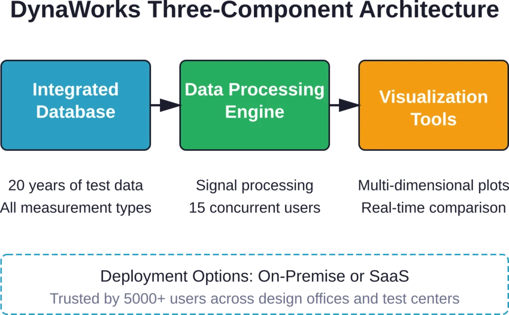
DynaWorks functions as a three-in-one solution. It combines an integrated database, data processing features, and visualization tools under a single interface. The architecture supports both on-premise installations and SaaS deployment models.
The database component stores 20 years of test measurements. That’s two decades of vibration data, thermal cycling results, acoustic testing outputs, and structural load measurements all accessible through a unified query system. For aerospace companies with long product lifecycles, this historical data becomes invaluable for comparative analysis and failure investigation.
Data processing capabilities center on algebraic operations and signal processing. The platform allows up to 15 users to handle these tasks independently and simultaneously. Real-time collaboration features let engineering teams work on different aspects of the same test dataset without version control conflicts.
Practical Applications
Test centers use DynaWorks to compare simulation models against physical test results. When a satellite component undergoes vibration testing, engineers can immediately overlay the measured response against finite element analysis predictions. Discrepancies trigger design reviews before hardware reaches expensive integration stages.
The visualization tools handle multi-dimensional datasets. Frequency response functions, time-domain waveforms, waterfall plots, and statistical distributions all render within the same environment. For spacecraft qualification programs that generate terabytes of sensor data, having fast, accurate visualization prevents bottlenecks in the approval chain.
Airbus emphasizes responsive support and customized training as part of the DynaWorks package. Aerospace testing protocols vary significantly between organizations and mission types. Off-the-shelf software rarely fits specialized workflows without configuration.
SurRender Software: Space Scene Image Simulation
Space missions depend on vision-based navigation systems. Whether approaching an asteroid, docking with the International Space Station, or landing on Mars, spacecraft cameras provide critical guidance data. But those systems need validation before launch.
That’s where SurRender comes in. Airbus has developed this image simulator since 2011 to support all phases of mission development—from initial feasibility studies through integration testing.
Technical Capabilities
SurRender generates physically accurate renderings of space environments. The software models celestial bodies, artificial satellites, planetary landers, and rovers with high geometric and photometric precision.
Lighting conditions in space differ dramatically from Earth-based scenarios. No atmospheric scattering. Extreme contrast between illuminated and shadowed surfaces. Reflected light from planetary bodies creates complex secondary illumination. SurRender’s rendering engine accounts for these physics.
The tool supports development and validation of vision-based navigation algorithms. Engineers can test how guidance systems respond to varying approach angles, lighting conditions, and target rotations without building expensive hardware prototypes.
Mission Applications
European Space Agency’s JUICE mission uses SurRender for image processing algorithm development. JUICE will explore Jupiter’s icy moons—environments where navigation poses unique challenges due to extreme distances and radiation.
Mars Sample Return Earth Return Orbiter (MSR ERO) mission planning also leverages SurRender. The mission requires precise orbital rendezvous and sample capsule capture. Simulating camera views under Martian orbital conditions helps validate guidance software long before hardware enters space.
Planetary lander guidance, navigation, and control (GNC) solutions benefit from SurRender’s terrain rendering capabilities. The software can generate synthetic imagery of approach trajectories over cratered surfaces, helping engineers tune descent algorithms for safe touchdowns.
Systema: Spacecraft Modeling and Analysis Platform
Systema addresses the early-to-detailed design phases of spacecraft development. The platform provides an open framework that adapts from conceptual studies through final design iterations.
User Interface and Workflow
The 3D interface allows engineers to create or import spacecraft models directly. Geometry building tools support rapid iteration during concept phases when configurations change frequently.
Data management features track design evolution across phases. As spacecraft concepts mature from rough sketches to detailed CAD models, Systema maintains linkages between geometric definitions and analysis results.
The framework’s flexibility proves valuable for multi-disciplinary teams. Thermal analysts, structural engineers, and mission designers can all work within the same environment, reducing data translation errors between specialized tools.
Analysis Toolboxes
Systema includes dedicated toolboxes for multiple engineering domains. Trajectory definition tools let mission planners explore orbital mechanics and maneuver sequences. Scenario specification capabilities enable “what-if” analysis for different mission profiles.
Result visualization features transform raw analysis outputs into interpretable 3D views. Temperature distributions across solar panels, structural stress concentrations, or field-of-view coverage maps all render in context with the spacecraft geometry.
The multi-physics analysis capabilities set Systema apart from general-purpose CAD tools. Aerospace spacecraft face coupled thermal-structural loading, radiation degradation, and orbital environment effects that require specialized simulation approaches.
Major industry players trust Systema for spacecraft design workflows. The platform’s track record spans telecommunications satellites, Earth observation systems, and scientific missions.
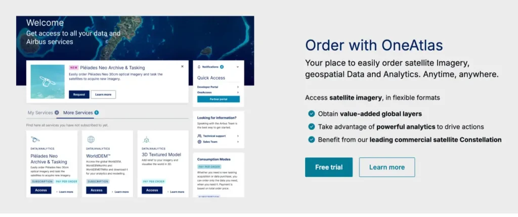
OneAtlas: Satellite Imagery Access Platform
OneAtlas represents Airbus’s commercial geospatial intelligence offering. The platform provides access to optical and radar satellite imagery through archive retrieval and new tasking orders.
Imagery Sources and Coverage
Airbus operates Pléiades Neo constellation—high-resolution optical satellites delivering 30 cm resolution imagery. Country-wide coverage programs capture recent imagery of priority regions.
Radar imagery comes from Synthetic Aperture Radar (SAR) satellites. SAR provides all-weather, day-night imaging capability. Cloud cover doesn’t degrade radar returns, making it valuable for regions with persistent weather challenges.
The archive contains historical imagery dating back years. For change detection analysis—tracking urban development, monitoring deforestation, or assessing disaster impact—historical baselines prove essential.
Access Models
OneAtlas supports both subscription and pay-per-order models. Organizations with ongoing intelligence requirements often choose subscription access. Project-based users order specific imagery products as needed.
The archive preview tool lets users browse available imagery before purchasing. Metadata shows acquisition date, cloud cover percentage, viewing angle, and quality metrics. This prevents ordering datasets that don’t meet project requirements.
New tasking allows customers to request fresh imagery of specific locations. Satellite operators schedule acquisitions based on orbital mechanics and imaging queue priorities. Turnaround times vary with urgency and target location.
| Platform | Primary Function | User Base | Key Capability |
|---|---|---|---|
| DynaWorks | Test data processing | 5000+ users | 20 years measurement history |
| SurRender | Image simulation | Space agencies, contractors | Vision-based navigation validation |
| Systema | Spacecraft modeling | Major industry players | Multi-physics analysis framework |
| OneAtlas | Satellite imagery access | Defense, intelligence, commercial | Optical and radar archive/tasking |
New Space Equipment Portfolio
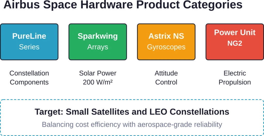
Beyond software, Airbus Space Solutions encompasses hardware products targeting next-generation space missions. The PureLine series, Sparkwing solar arrays, Astrix NS gyroscopes, and Power Processing Unit NG2 all support modern constellation and small satellite architectures.
PureLine Series
The PureLine product line targets constellation applications requiring high production volumes. Airbus positions these components as delivering disruptive pricing without compromising quality standards.
Constellation operators need cost-effective, reliable hardware. When deploying dozens or hundreds of satellites, component costs multiply rapidly. PureLine addresses this economic reality while maintaining aerospace-grade performance.
Sparkwing Solar Arrays
Sparkwing arrays offer up to 200 W/m² power output. The design uses lightweight carbon-fiber panels and scales for small satellite platforms.
Low Earth Orbit (LEO) missions benefit from Sparkwing’s fast, reliable deployment mechanism. Solar array deployment represents a single-point failure mode. If panels don’t unfold correctly, missions end before they begin. Proven deployment reliability matters.
Astrix NS Gyroscopes
Attitude control systems require precise angular rate measurements. Astrix NS gyroscopes deliver that precision for demanding space operations.
Satellite positioning accuracy directly impacts mission utility. Earth observation systems need stable pointing to maintain image quality. Communications satellites must track ground stations with minimal drift. Scientific instruments often have narrow field-of-view constraints.
Power Processing Unit NG2
Advanced electric propulsion systems require sophisticated power conditioning. The NG2 unit supports modern electric thruster architectures.
Electric propulsion has revolutionized spacecraft design. Chemical rockets provide high thrust but low efficiency. Electric systems offer far higher specific impulse, enabling orbit-raising and station-keeping with minimal propellant mass. The trade-off is complexity in power processing electronics.
Skywise Core Integration for Aircraft Operations
While not exclusively a space tool, Skywise Core demonstrates Airbus’s broader approach to data-driven operations. The platform connects over 12,300 aircraft worldwide, leveraging real-time data for predictive maintenance and optimized operations.
This aircraft-focused platform shares architectural principles with space-oriented tools. Centralized data management, multi-user collaboration, and analytics-driven decision support appear across Airbus’s software ecosystem.
Skywise Core users report 10% to 20% time saved in maintenance operations. One technical pilot noted that a 0.3 point gap in monitoring equals 10% savings in maintenance costs. Those economics matter when operating large fleets.
The platform runs on technology from Palantir Technologies, a data analytics provider. This partnership brings sophisticated data fusion capabilities to aerospace operations.
Defense and Intelligence Applications
Airbus Space Solutions serves defense and national security customers with specialized capabilities. Military satellite communications, surveillance systems, and secure connectivity solutions form a significant business segment.
Space-Based Communications
Military operations require secure, resilient communications across land, air, sea, and orbital domains. Airbus’s satellite communication systems ensure forces remain connected even under contested conditions.
The growing volume of battlefield data demands higher bandwidth. Modern sensor platforms—UAVs, reconnaissance satellites, distributed ground sensors—generate massive data streams. Communications infrastructure must scale accordingly.
Secure connectivity solutions preserve national sovereign interests. Communications security isn’t just encryption. It encompasses anti-jamming techniques, low-probability-of-intercept waveforms, and redundant routing.
Earth Observation for Defense
Military Earth observation satellites strengthen situational awareness. Intelligence analysts depend on timely, high-resolution imagery for threat assessment, treaty monitoring, and operational planning.
Airbus’s geospatial products deliver actionable intelligence from satellite imagery. The combination of optical and radar sensors provides comprehensive coverage regardless of weather or lighting.
Information superiority drives modern military advantage. Forces that detect threats first, identify targets accurately, and update intelligence rapidly maintain decision-making initiative.
Recent Strategic Partnerships and Technology Development
Airbus continues expanding space capabilities through strategic collaborations. A 2 February 2026 announcement revealed Memorandums of Understanding with ST Engineering to jointly explore and develop advanced satellite capabilities and AI-powered solutions.
Next-Generation SAR Capabilities
The collaboration focuses on 3D radar capabilities and synthetic aperture radar advancement. SAR technology has matured significantly, but next-generation systems promise improved resolution, faster revisit times, and enhanced interferometric processing.
Three-dimensional radar mapping enables terrain modeling, infrastructure monitoring, and change detection with centimeter-scale precision. Applications span defense reconnaissance, disaster response, and commercial infrastructure management.
AI-Enabled Geospatial Analytics
Artificial intelligence transforms how organizations extract value from satellite imagery. Manual image analysis doesn’t scale when constellations generate petabytes of data annually.
Machine learning algorithms can detect objects, classify land cover, identify changes, and flag anomalies automatically. These capabilities convert raw imagery into actionable intelligence at scale.
The partnership aims to meet evolving market and customer needs. Geospatial intelligence users demand faster processing, more sophisticated analysis, and tighter integration with operational workflows.
Review Satellite Data with FlyPix AI
Airbus Space Solutions is connected with satellite data, Earth observation, and space-based information services. FlyPix AI can work with satellite, drone, and aerial imagery to help teams detect objects, segment areas, and review visible changes across land, infrastructure, agriculture, or environmental sites.
FlyPix AI can support satellite and aerial image analysis tasks such as:
- Detecting visible objects, roads, buildings, vegetation, or infrastructure
- Segmenting land cover, water, agricultural areas, or built environments
- Comparing imagery across time to monitor visible changes
- Creating custom AI models for specific Earth observation use cases
Contact FlyPix AI to discuss how geospatial image analysis can support satellite-based review work.
User Experience and Integration Considerations
Implementing Airbus Space Solutions tools requires understanding organizational workflows, technical infrastructure, and user training needs.
Learning Curve and Training
These platforms aren’t consumer applications. They assume aerospace engineering knowledge and domain expertise. DynaWorks users need understanding of signal processing, structural dynamics, and test methodology.
Airbus provides customized training programs. Generic training materials rarely address organization-specific workflows and data formats. Tailored instruction accelerates user proficiency.
Responsive support matters when mission-critical work depends on software reliability. Aerospace programs operate under strict schedules. Tool failures that halt progress for days or weeks cascade through project timelines.
Integration with Existing Systems
Large aerospace organizations maintain complex IT ecosystems. Product lifecycle management systems, simulation tools, document management platforms, and collaboration software all need interoperability.
DynaWorks offers both on-premise and SaaS deployment. On-premise installations integrate more easily with legacy infrastructure but require internal IT support. SaaS models simplify deployment but may face security restrictions in defense environments.
Data exchange formats determine integration success. Supporting standard file formats (HDF5, CSV, STEP, IGES) eases workflows. Proprietary formats create friction.
Competitive Landscape and Market Position
Airbus doesn’t monopolize aerospace software. Organizations can choose from multiple vendors depending on specific needs.
Test Data Management Alternatives
National Instruments, Siemens, and specialized aerospace software companies offer competing test data solutions. Each brings different strengths in data acquisition hardware integration, analysis capabilities, or industry-specific features.
DynaWorks differentiates through its extensive measurement archive and aerospace-specific processing algorithms. Generic test tools require significant customization for spacecraft qualification workflows.
Image Simulation Competition
Simulation software vendors like AGI (Analytical Graphics Inc.) provide space environment modeling tools. NASA and ESA have developed internal simulation capabilities for mission-critical applications.
SurRender’s advantage lies in Airbus’s direct spacecraft development experience. The tool evolved from actual mission needs rather than academic research or general-purpose simulation.
Geospatial Intelligence Providers
The satellite imagery market includes multiple commercial providers. Maxar Technologies, Planet Labs, and various national space agencies all offer Earth observation data.
Airbus’s Pléiades Neo constellation delivers competitive resolution with favorable revisit times. OneAtlas’s combined optical and radar access provides flexibility that single-sensor providers can’t match.
Pricing and Procurement Considerations
Airbus doesn’t publish public pricing for most Space Solutions tools. These platforms target institutional customers with bespoke requirements.
Pricing models vary by product. DynaWorks may follow user-based licensing. OneAtlas uses subscription tiers or per-image pricing depending on customer needs. Custom spacecraft hardware quotes depend on specifications and order volume.
Procurement typically involves direct engagement with Airbus sales teams. Organizations should prepare detailed requirements, anticipated usage volumes, and integration constraints before initiating discussions.
For current pricing information across Airbus Space Solutions products, contact Airbus Defence and Space directly through their official channels.
Future Roadmap and Technology Trends
Space industry trends shape Airbus’s development priorities. Several areas warrant attention for organizations planning long-term tool adoption.
Constellation Operations at Scale
Mega-constellations with hundreds or thousands of satellites require operations automation. Traditional spacecraft operations—where teams of specialists monitor individual satellites—don’t scale economically.
Software tools will increasingly incorporate autonomous operations, automated anomaly detection, and fleet-level management. Airbus’s platform development will likely reflect these needs.
AI and Machine Learning Integration
The ST Engineering partnership signals Airbus’s AI investment direction. Machine learning will permeate multiple tool categories—from automated test data analysis in DynaWorks to object recognition in OneAtlas imagery.
AI adoption in aerospace faces regulatory and certification challenges. When algorithms influence safety-critical decisions, validation requirements intensify. Expect gradual integration rather than wholesale replacement of traditional methods.
Cloud-Native Architectures
SaaS delivery models gain traction even in defense sectors. Cloud infrastructure offers elastic scaling, geographic distribution, and reduced IT overhead.
Security concerns slow cloud adoption for classified work. Hybrid architectures—processing unclassified data in commercial clouds while maintaining secure on-premise systems for sensitive material—represent pragmatic compromises.
| Trend | Impact on Tools | Timeline | Challenges |
|---|---|---|---|
| Constellation scale | Automated operations features | 2026-2028 | Reliability at scale |
| AI integration | Intelligent analysis, detection | 2026-2030 | Certification, validation |
| Cloud adoption | SaaS-first architectures | 2026-2029 | Security, sovereignty |
| Digital twins | Integrated simulation models | 2027-2031 | Data fidelity, complexity |
Strengths and Limitations Assessment
No tool suite perfectly fits every organization. Understanding where Airbus Space Solutions excels—and where alternatives might prove better—enables informed decisions.
Key Strengths
Deep aerospace heritage represents Airbus’s primary advantage. These tools emerged from actual spacecraft development, not abstract requirements. The company builds satellites, operates missions, and maintains defense systems. Software capabilities reflect hard-earned operational knowledge.
An integrated ecosystem benefits organizations using multiple tools. Data flows between DynaWorks test results, Systema design models, and SurRender simulations more smoothly than connecting disparate vendor products.
Scale and support infrastructure matter for mission-critical applications. Airbus maintains global support teams, training programs, and long-term product roadmaps. Small vendors may offer innovative features but lack enterprise-grade support.
Potential Limitations
Specialized aerospace focus means steeper learning curves. Organizations with limited aerospace expertise may struggle with platform complexity. More accessible tools exist for simple workflows.
Enterprise pricing reflects professional-grade capabilities. Budget-constrained projects might find commercial alternatives more economical for non-critical applications.
Vendor lock-in concerns arise with integrated ecosystems. Organizations heavily invested in Airbus tools face switching costs if requirements change. Maintaining data portability through standard formats mitigates this risk.
Frequently Asked Questions
Aerospace manufacturers, space agencies, defense contractors, satellite operators, and geospatial intelligence organizations represent primary users. Applications span spacecraft design, satellite constellation operations, military communications, Earth observation, and mission simulation. Research institutions developing space technologies also leverage these platforms for academic and government-sponsored programs.
According to official Airbus data from 2024, DynaWorks supports over 5000 users worldwide across design offices, test centers, and industrial project stakeholders. The platform stores 20 years of test measurements and allows up to 15 users to handle algebraic tasks and signal processing independently and simultaneously.
Yes. OneAtlas provides both subscription and pay-per-order access models. Organizations can purchase specific imagery products for individual projects without long-term commitments. The archive preview tool allows browsing available imagery before ordering, helping control costs by ensuring datasets meet requirements before purchase.
DynaWorks supports both on-premise installations and Software-as-a-Service (SaaS) deployments. On-premise installations suit organizations with existing IT infrastructure and security requirements for local data control. SaaS deployments provide faster implementation with reduced IT overhead, though some defense and classified environments may restrict cloud-based tools.
SurRender supports the European Space Agency’s JUICE mission exploring Jupiter’s icy moons, the Mars Sample Return Earth Return Orbiter (MSR ERO) program, and various planetary lander guidance, navigation, and control solution developments. The software enables validation of vision-based navigation techniques across mission development phases from feasibility studies through integration testing.
Systema provides spacecraft-specific modeling and analysis capabilities beyond general CAD software. The platform includes dedicated toolboxes for trajectory definition, scenario specification, multi-physics space analysis, and advanced visualization of engineering results. Its open framework adapts from early conceptual design through detailed final design, supporting thermal-structural coupling, radiation effects, and orbital environment analysis specific to spacecraft applications.
Airbus offers responsive technical support, customized training programs tailored to organization-specific workflows, and ongoing platform evolution based on user needs. Support infrastructure includes global teams, domain-expert assistance for aerospace-specific challenges, and long-term product roadmaps ensuring continued capability development and compatibility with evolving industry standards.
Conclusion: Strategic Value for Space Programs
Airbus Space Solutions represents a comprehensive toolkit addressing critical needs across spacecraft lifecycles. From initial concept through on-orbit operations, these platforms support engineering workflows that determine mission success.
DynaWorks tackles the persistent challenge of test data management—converting mountains of measurements into actionable engineering insights. SurRender enables validation of vision-based navigation without expensive hardware prototypes. Systema provides the multi-physics analysis framework that spacecraft complexity demands. OneAtlas delivers the geospatial intelligence that drives defense and commercial decision-making.
These aren’t plug-and-play consumer apps. They require aerospace expertise, thoughtful integration, and organizational commitment. But for programs where reliability, precision, and proven heritage matter, Airbus brings decades of operational experience to software development.
The space industry continues rapid evolution. Constellations grow larger. Missions grow more ambitious. Data volumes explode. Airbus’s strategic partnerships and technology investments signal continued platform advancement aligned with emerging needs.
Organizations evaluating space engineering tools should assess specific workflow requirements, integration constraints, and long-term support needs. Contact Airbus Defence and Space directly to explore how Space Solutions platforms might address your program’s unique challenges.