
Quick Summary: Albedo measurement tools have evolved from laboratory equipment to practical smartphone apps and free web-based solutions for solar projects. Modern albedo tools serve diverse users—from solar engineers calculating bifacial panel performance to climate researchers monitoring surface reflectivity. The best albedo tool depends on your use case: quick field measurements favor mobile apps with gray card calibration, while scientific research demands spectroradiometer-grade instruments.
Albedo represents the ratio of radiation reflected from a surface to the total amount incident upon it. For solar projects, this number isn’t academic—it’s money.
Vertical solar panels can see energy yield increase up to 40% when installed over high-albedo surfaces. Bifacial modules capture reflected light on their rear side, turning what was wasted ground bounce into usable electricity.
But here’s the thing: albedo still gets treated as an assumed value in most solar designs. Engineers plug in generic numbers—0.20 for grass, 0.30 for concrete—without measuring the actual site.
That approach leaves performance on the table. Real roofs don’t match textbook values. Age, weathering, and local conditions create variations that generic tables can’t capture.
The good news? Measuring albedo on-site has become dramatically easier. Smartphone apps now deliver field measurements accurate enough for commercial solar projects. Scientific instruments provide laboratory-grade precision. And free web tools make albedo estimation accessible to anyone with a camera.
Why Albedo Measurement Matters for Solar Projects
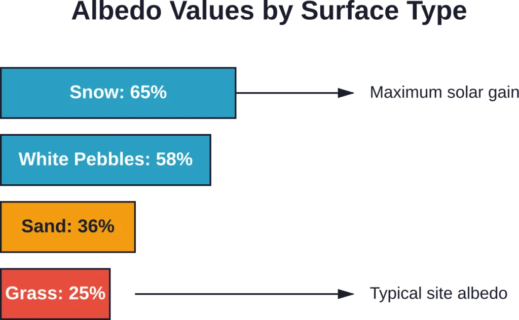
Snow-covered ground reflects up to 65% of incoming solar radiation. White pebbles bounce back 58%. Plain grass? Just 25%.
For a bifacial solar installation, that difference translates directly to the bottom line. A module over white gravel generates more electricity than the identical panel over bare soil.
But most solar design software asks for a single albedo value per site. Enter the wrong number and the energy yield predictions miss the mark by double-digit percentages.
Conventional albedo measurement required expensive pyranometers positioned at specific heights, with data logging equipment and careful calibration. The process was accurate but completely impractical for most projects.
Vertical solar installations face an even more complex challenge. The panels “see” ground reflectance at steep angles, where surface texture and viewing geometry change the effective albedo.
Climate research adds another layer. Urban albedo affects local temperatures—research published in medical journals shows asphalt pavement albedo ranging from 0.08 to 0.20 produces temperature reductions up to 10°C. Increasing that range to 0.40–0.59 pushes temperature reduction to 15°C.
Free Smartphone-Based Albedo Apps
The breakthrough in practical albedo measurement came from smartphone apps that use the device’s camera as a light meter.
These tools work by comparing the light reflected from the surface you’re measuring to the light reflected from a reference target with known reflectance. That reference is typically an 18% gray card—the same tool photographers use for color calibration.
The albedo app approach sidesteps the need for expensive calibrated pyranometers. Your smartphone camera becomes the sensor.
Over Easy Albedo App
The Over Easy albedo app stands out as a free, web-based solution requiring no installation. Just navigate to the tool in your smartphone browser.
What you need: a smartphone and a gray card. The gray card provides the known 18% reflectance reference.
The measurement workflow is straightforward. Position the gray card on the surface. Take a photo that captures both the gray card and surrounding surface in the same lighting conditions. The app’s algorithm compares the reflectance values and calculates albedo.
Over Easy developed a self-calibration algorithm that extracts a more exact estimate from two pictures taken on site. This approach compensates for variations in camera response and ambient lighting.
The tool includes practical features for project workflows: measurement storage, location tagging, notes fields, and PDF export. Those exports integrate directly into solar design documentation.
Real talk: this won’t match laboratory precision. But for solar project feasibility and design, the accuracy lands in the “good enough” zone. And the price—free—makes it accessible for every project, not just the ones with big budgets.
Albedo Educator Platform
Wait, there’s another “Albedo” tool? Yes, but it serves a completely different purpose.
Albedo Educator is a personalized online learning platform offering 1-to-1 tutoring for students. Despite sharing the albedo name, it has zero connection to solar measurement or surface reflectance.
The platform focuses on educational mentorship with experienced educators, small batch sessions, and flexible scheduling. File size clocks in at 31.9 MB for the iOS version.
The name collision creates confusion in app store searches. When looking for albedo measurement tools, filter results carefully—educational apps and solar engineering tools occupy completely different categories.
Professional Albedo Measurement Instruments
Scientific research and satellite validation demand measurement accuracy that smartphone apps can’t deliver. That’s where dedicated instruments come in.
Spectroradiometers measure surface reflectance across multiple wavelength bands with laboratory-grade precision. These devices underpin NASA’s albedo data products derived from satellite imagery.
NASA Earthdata provides VIIRS/JPSS2 BRDF and Albedo data at multiple spatial resolutions: 0.05 degree Climate Modeling Grid (CMG), 500m SIN Grid, and 1km SIN Grid. All formats deliver Daily L3 global coverage in HDF-EOS5 format.
Valid range for BRDF/Albedo mandatory quality bands spans 0 to 1, stored as uint8 data type. This represents the physical reality—albedo cannot exceed 100% (a value of 1.0).
| Data Product | Spatial Resolution | Temporal Coverage | Format |
|---|---|---|---|
| VIIRS/JPSS2 BRDF Albedo | 500m, 1km, 0.05° | Daily L3 Global | HDF-EOS5 |
| HLS Landsat OLI | 30m | Daily Global | HDF-EOS5 |
| Landsat 10 (planned 2031) | Variable by band | 18-day revisit | TBD |
The upcoming Landsat 10 mission—expected to launch in 2031—will continue the world’s longest space-based record of Earth’s land surface with enhanced spectral capabilities and improved calibration accuracy. Specific band counts should be verified with current NASA documentation.
Radiometric performance requirements maintain continuity with Landsat 8 and 9 heritage bands. Specific performance targets should be verified with current Landsat 10 mission documentation.
Geometric accuracy requirements have been updated to support Landsat 10’s finer spatial resolutions. Temporal revisit intervals maintain the Landsat program legacy.
Comparing Albedo Tool Accuracy
So how do these tools stack up against each other?
Laboratory spectroradiometers represent the gold standard. Properly calibrated instruments deliver albedo measurements with uncertainty below 2% in controlled conditions.
Satellite-derived albedo products like those from VIIRS offer global coverage but trade spatial resolution for breadth. The 500m resolution means each pixel averages albedo across an area larger than most solar installations.
Smartphone apps with gray card calibration fall somewhere in between. Testing suggests measurement uncertainty in the 5-10% range under good conditions—adequate for commercial solar design, less suitable for research validation.
Accuracy also depends on measurement conditions. Direct sunlight, stable weather, and proper technique matter more than the tool itself. A smartphone app used carefully outperforms a spectroradiometer wielded carelessly.
Albedo Tools for Specific Applications
Different use cases demand different tools. Here’s how to match tools to tasks.
Solar Project Design and Feasibility
For commercial solar installations, smartphone-based albedo apps hit the sweet spot. The measurement accuracy lands within acceptable margins for energy yield calculations. The tools cost nothing. And field teams can collect data during standard site surveys without specialized equipment.
Bifacial module projects benefit most from on-site measurement. The rear-side energy gain depends directly on accurate albedo input. Generic assumptions introduce more error than measurement uncertainty from an app.
Climate Research and Urban Planning
Urban heat island studies need higher precision. The temperature effects of albedo changes are small enough that measurement error matters.
Research on urban surface albedo impacts, such as the study showing asphalt albedo increase from 0.08-0.20 to 0.40-0.59 producing temperature reductions from 10°C to 15°C, relied on controlled spectroradiometer measurements.
For these applications, invest in calibrated instruments or use validated satellite data products.
Reforestation and Carbon Projects
Albedo matters for reforestation projects because changing land cover from bare ground to forest alters surface reflectance. That change affects the local and regional climate.
Recent studies found albedo changes could wholly negate the cooling effect of up to 12% of afforestation efforts. The darker forest canopy absorbs more solar radiation than the lighter ground it replaced, partially offsetting the carbon sequestration benefit.
Carbon project accounting increasingly incorporates albedo effects. This requires baseline albedo measurement before tree planting, then monitoring as the canopy develops. Satellite-derived data products work well here—the temporal coverage captures changes over years.
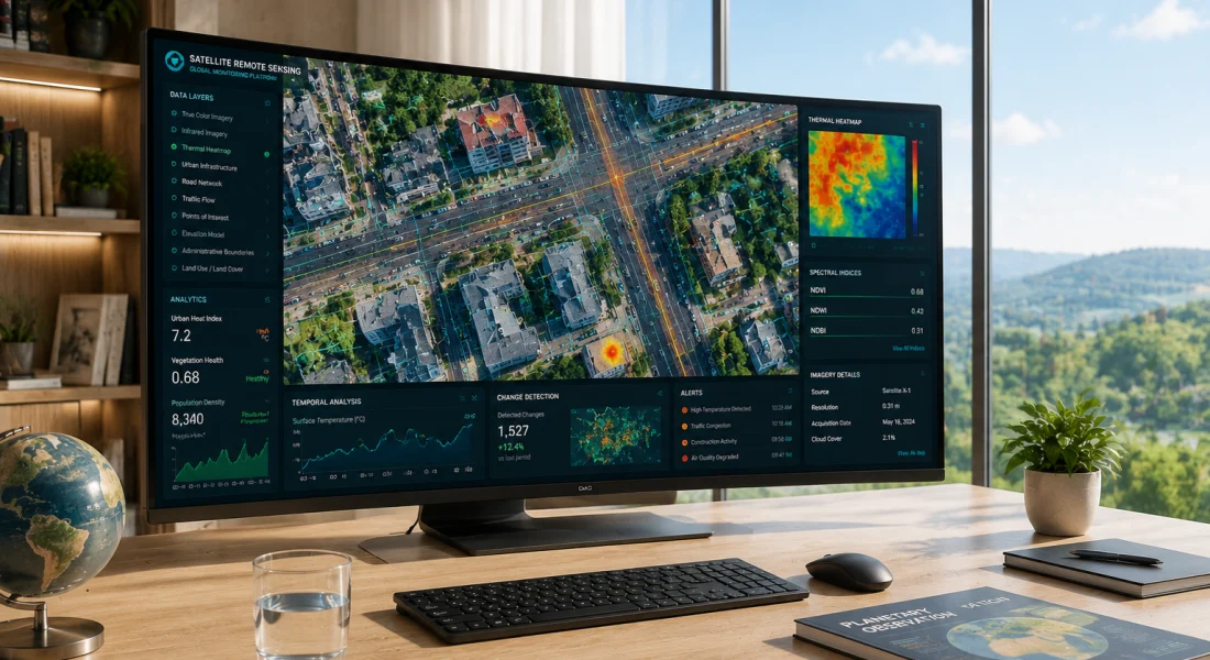
Analyze Satellite Imagery with FlyPix AI
Albedo is connected with Earth observation data. FlyPix AI fits naturally into connected issues by helping teams analyze satellite, drone, and aerial imagery to detect objects, segment areas, and review visible changes across mapped locations.
FlyPix AI can support satellite image analysis tasks such as:
- Detecting buildings, roads, vehicles, vegetation, or other visible objects
- Segmenting land, water, agricultural areas, infrastructure, or built zones
- Comparing satellite or aerial imagery across different dates
- Training custom AI models for specific geospatial detection needs
Contact FlyPix AI to discuss how geospatial image analysis can support satellite-based review work.
Best Practices for On-Site Albedo Measurement
Regardless of which tool is used, measurement technique affects accuracy more than the instrument itself:
- Timing matters: Measure during stable midday conditions when the sun is high. Avoid early morning, late afternoon, or variable cloud cover. The reference and measurement surface must receive identical illumination.
- Surface preparation is minimal: Don’t clean, brush, or modify the surface. Real-world albedo is what gets measured, not theoretical maximum reflectance.
- Multiple measurements beat single readings: Take 3-5 measurements across different areas of the site. Average the results. This accounts for spatial variation.
- Document everything: Photo documentation, GPS coordinates, date, time, weather conditions. Albedo measurements become part of project records. Future teams need context to interpret the numbers.
For smartphone apps specifically: ensure the gray card and measurement surface are in the same plane and lighting. Camera angle matters less than consistency between reference and target shots.
Cost Analysis: Free vs. Paid Albedo Tools
Budget influences tool selection as much as technical requirements do.
| Tool Type | Cost Range | Best For | Limitations |
|---|---|---|---|
| Free Smartphone App | $0 (requires gray card ~$10) | Solar feasibility, site surveys | ±5-10% accuracy |
| Handheld Spectroradiometer | $5,000-$20,000 | Research validation, precision work | Requires training, calibration |
| Satellite Data Access | Free (NASA Earthdata) | Large-area studies, temporal analysis | 500m-1km resolution limit |
| Pyranometer Pair Method | $2,000-$5,000 | Continuous monitoring | Fixed location only |
The free options—smartphone apps and satellite data—cover most commercial needs. Specialized instruments make sense when measurement precision directly affects project economics or when producing publishable research.
Gray cards cost around $10 and last indefinitely if stored properly. That’s the only consumable expense for smartphone-based measurement.
Future of Albedo Measurement Technology
Albedo tools continue evolving toward greater accessibility without sacrificing accuracy.
Machine learning algorithms now extract albedo from standard site photos without reference cards. These tools train on spectroradiometer datasets, learning to recognize surface properties from image characteristics. Early results show promise but need more field validation.
Drone-mounted sensors enable rapid albedo mapping across large sites. Commercial solar projects spanning hundreds of acres can characterize spatial variation in minutes rather than hours of ground surveys.
Integration with solar design software eliminates manual data transfer. Measure albedo in the field, sync to the cloud, and see updated energy yield projections automatically. Several platforms already offer this workflow.
Satellite data products improve in both spatial and temporal resolution. NASA’s Landsat 10 mission planned for 2031 continues this trend with enhanced spectral capabilities and improved calibration accuracy.
Common Albedo Measurement Mistakes
Even good tools produce bad data when used incorrectly. Watch for these pitfalls:
- Shadow contamination: The operator, equipment, or nearby structures cast shadows on the measurement area. This artificially lowers the measured albedo. Step back and verify nothing blocks direct sunlight.
- Wet surface measurement: Water drastically reduces albedo. A surface measured after rain shows much lower reflectance than the same surface dry. Wait for complete drying or note the condition explicitly.
- Wrong time of day: Low sun angles change the effective albedo due to surface geometry effects. Stick to solar noon ±2 hours for consistency.
- Ignoring spatial variation: One measurement in one location characterizes one square meter, not the entire site. Large installations need systematic sampling across the project area.
- Mixing reference standards: Gray cards vary. An 18% reference card is not interchangeable with a white balance card. Verify the reference specification matches the app’s expectation.
Frequently Asked Questions
The most accurate on-site method uses a calibrated spectroradiometer or paired pyranometer system (one upward-facing for incoming radiation, one downward-facing for reflected radiation). These instruments achieve measurement uncertainty below 2%. However, for commercial solar projects, smartphone apps with gray card calibration deliver sufficient accuracy (5-10% uncertainty) at near-zero cost. The best method depends on whether the project requires research-grade precision or practical engineering estimates.
Yes. Free smartphone-based albedo apps like the Over Easy tool require only a phone’s camera and an 18% gray card (around $10). The app compares light reflected from the surface to light reflected from the known reference. This approach provides adequate accuracy for solar project feasibility studies, energy yield calculations, and site characterization. It won’t match laboratory precision but eliminates the barrier of expensive equipment.
Bifacial solar modules capture light on both front and rear surfaces. The rear side generates electricity from ground-reflected radiation, with output directly proportional to surface albedo. High-albedo surfaces like white gravel (58% reflectance) or snow (65% reflectance) dramatically increase rear-side generation compared to grass (25% reflectance). For vertical solar installations, high albedo can increase total energy yield by up to 40%. Accurate albedo measurement during design prevents overestimation or underestimation of bifacial gain.
When on-site measurement isn’t feasible, use conservative published values: bare soil 17%, grass 25%, dry grass 30%, sand 36%, white pebbles 58%, concrete 0.20-0.40, asphalt 0.05-0.20 depending on age and condition. Remember these are typical ranges—real surfaces vary by weathering, moisture, and local conditions. For commercial solar projects with significant bifacial contribution, the cost of a 30-minute on-site measurement with a free app is negligible compared to the risk of incorrect design assumptions affecting 25-year revenue projections.
Absolutely. Wet surfaces show much lower albedo than dry surfaces because water absorbs more radiation. Cloud cover changes both the intensity and spectral distribution of illumination, affecting measurement consistency. Wind can introduce shadows from moving objects or blow dust onto surfaces. For reliable measurements, work during stable midday conditions (solar noon ±2 hours), clear skies or consistent overcast, dry surfaces, and light wind. Document weather conditions with every measurement for future reference and comparison.
Measure albedo during initial site assessment and design. Remeasure before construction if more than six months elapsed—surfaces change with weather, vegetation growth, or human activity. Post-construction measurement verifies as-built conditions match design assumptions. Ongoing monitoring matters less for fixed installations but becomes important for performance troubleshooting. Unexpected generation shortfalls might trace to albedo changes from vegetation growth, surface soiling, or seasonal effects. For research installations or demonstration projects, quarterly measurements capture seasonal variation.
Satellite-derived albedo products from NASA Earthdata (VIIRS, Landsat) provide excellent spatial coverage and temporal consistency. The 500m to 1km spatial resolution works well for landscape-scale studies, climate research, and large utility-scale solar projects. However, most commercial solar installations are smaller than a single satellite pixel. The satellite measurement averages albedo across a 500m×500m area (25 hectares), which may include the project site plus surrounding fields, roads, and buildings. For project-specific design, on-site measurement better captures the actual surface conditions the modules will see.
Conclusion
Albedo measurement has shifted from specialized research activity to practical engineering tool. Free smartphone apps democratize access to data that directly affects solar project economics. Professional instruments deliver the precision scientific research demands. And satellite products provide the geographic scope climate studies require.
The best albedo tool isn’t the most expensive or most accurate—it’s the one that matches specific application requirements and actually gets used in the field.
For most solar projects, start with a free smartphone app and an 18% gray card. Take measurements during midday under stable conditions. Document everything. And integrate those real-world numbers into design software instead of relying on generic assumptions.
The difference between measured and assumed albedo can represent thousands of dollars in project value. That’s a compelling return in 30 minutes with a free app.