
")
Quick Summary: A3 Environmental Consultants uses a modern technology stack combining Formsite for site assessment questionnaires, Bluebeam for document collaboration, and CADD/GIS platforms for spatial analysis. Their toolkit enables efficient Phase I ESA workflows, UST compliance audits, wetland delineation, and environmental remediation projects across Northern Illinois.
Environmental consulting demands precision, efficiency, and regulatory compliance at every step. A3 Environmental Consultants has built its reputation on delivering Phase I ESAs, remediation services, and ecological assessments with a combination of proven methodologies and modern digital tools.
But here’s the thing—environmental work isn’t just about field boots and soil samples anymore. The technology supporting site assessments, data collection, and client collaboration shapes project timelines, accuracy, and cost.
So what exactly does A3 Environmental use to streamline workflows? What tools power their environmental due diligence, remediation tracking, and compliance audits?
Core Technology Stack at A3 Environmental
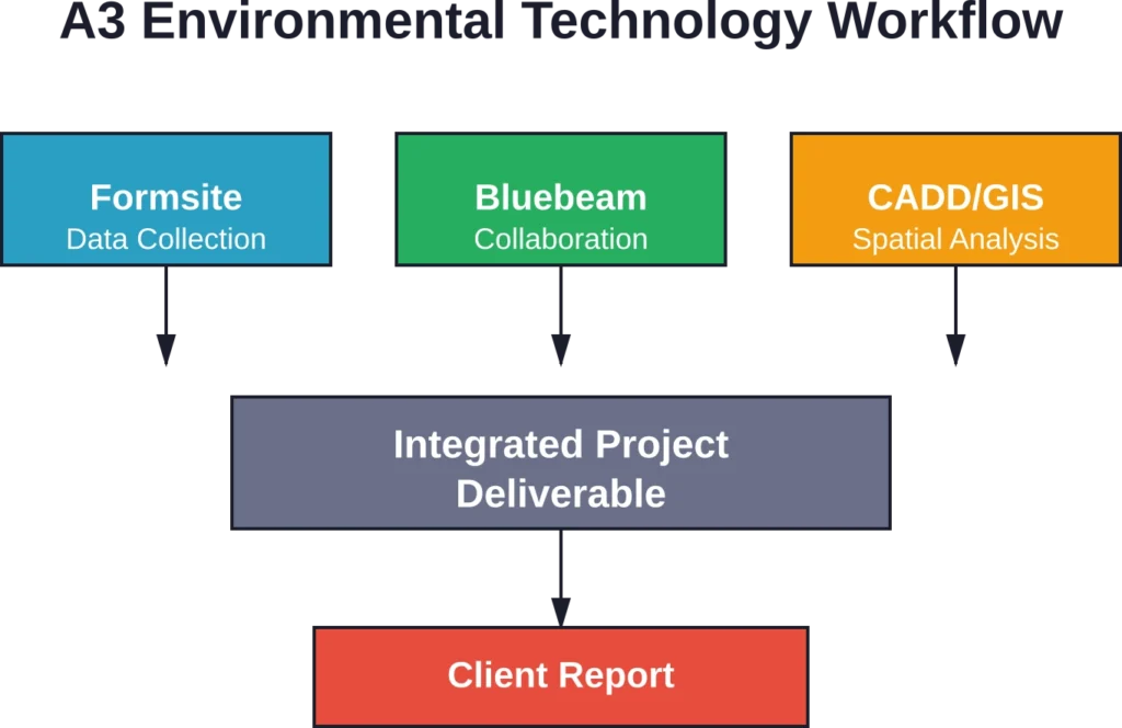
A3 Environmental Consultants operates with a deliberate technology strategy that prioritizes cost-effectiveness, ease of use, and data integrity. Rather than investing in expensive enterprise platforms, they’ve assembled a toolkit of specialized applications that integrate seamlessly into their project workflows.
Formsite for Digital Questionnaires
According to A3’s own Phase I ESA documentation, they rely on Formsite as their questionnaire platform. This cloud-based form builder costs just $15 per month and handles critical data collection tasks during environmental site assessments.
The tool serves two primary functions. First, it powers the Phase I ESA User Questionnaire—the structured interview that captures site history, operations, and potential environmental concerns from current owners or operators. Second, it manages owner questionnaires for historical property use documentation.
Formsite’s advantage lies in its conditional logic capabilities. Questions adapt based on previous answers, creating a streamlined experience for respondents while ensuring consultants capture all necessary regulatory details. Data exports directly into spreadsheet formats for analysis and reporting.
Bluebeam for Consultant Coordination
Environmental projects rarely happen in isolation. They involve architects, engineers, surveyors, and regulatory agencies—all working from the same site plans, maps, and documentation.
Community discussions among architects reveal widespread adoption of Bluebeam Sessions for multi-party document collaboration. The platform creates shared repositories of drawings where teams review, markup, and comment in real time. Bluebeam’s snip-and-overlay functionality allows consultants to extract portions of site plans and layer them onto environmental reports, wetland delineation maps, or remediation diagrams.
For A3 Environmental, this translates into faster turnaround on projects requiring coordination with civil engineers, land surveyors, or municipal planning departments across Northern Illinois.
CADD and GIS Services
A3 Environmental maintains dedicated CADD and GIS consulting capabilities for spatial analysis, site mapping, and environmental data visualization. These technologies support wetland delineation projects, stream restoration planning, and contamination plume modeling during remediation work.
Geographic Information Systems enable overlay analysis—combining soil maps, hydrology data, historical aerial imagery, and field survey points into comprehensive site assessments. Computer-Aided Design software produces technical drawings for remediation system installations, UST removal plans, and ecological restoration designs.
Project Applications and Service Delivery
Technology only matters when it solves real problems. Here’s how A3 Environmental applies these tools across their core service lines.
Phase I Environmental Site Assessments
Phase I ESAs represent the foundation of environmental due diligence in commercial real estate transactions. These assessments follow ASTM E1527 standards and require systematic data collection, site reconnaissance, historical research, and regulatory database review.
A3 Environmental created a comprehensive Phase I ESA Site Assessment Checklist specifically for freelance environmental consultants. The checklist follows the typical progression of a site visit and ensures consistent coverage of all required assessment components.
Formsite questionnaires capture owner and operator knowledge about site history, underground storage tanks, hazardous materials handling, and neighboring property uses. This digital approach eliminates handwritten field notes and accelerates report turnaround.
According to EPA systematic planning guidance, effective environmental investigations require clear identification of project managers, stakeholders, data users, and decision-makers from the outset. Digital workflows make stakeholder coordination more transparent throughout the assessment process.
Underground Storage Tank Compliance and Removal
Public utility providers across Northern Illinois rely on A3 Environmental for UST removal, closure documentation, and compliance audits with the Office of the State Fire Marshal.
UST projects demand precise documentation. Tank registration records, leak detection system testing, corrosion inspections, overfill prevention checks—all must be current and compliant. A3 conducts systematic UST Compliance Audits using standardized checklists that flag regulatory gaps before OSFM inspections.
When tank removals proceed, project documentation tracks soil sampling locations, analytical results, contamination extent if releases occur, and closure certification. CADD software produces scaled site diagrams showing tank locations, excavation boundaries, and sampling points required for regulatory submittals.
Ecological Services and Wetland Delineation
Wetland delineation projects require field data collection, boundary mapping, and coordination with U.S. Army Corps of Engineers jurisdictional determination processes. GIS technology proves essential for these assessments.
Field crews use GPS equipment to capture wetland boundary coordinates, vegetation sample plots, and soil boring locations. Back at the office, GIS platforms overlay these field points onto topographic maps, aerial imagery, and National Wetlands Inventory data to produce delineation exhibits for Corps review.
A3 Environmental’s project profile for the City of Belvidere 6th Street Channel Naturalization demonstrates this workflow. The project addressed chronic sediment accumulation in a municipal stormwater channel, requiring stream restoration design, regulatory permitting, and ecological monitoring—all supported by spatial analysis tools.
| Service Type | Primary Tools | Key Deliverables |
|---|---|---|
| Phase I ESA | Formsite, Bluebeam | ASTM-compliant assessment report |
| UST Compliance Audit | Digital checklists, CADD | OSFM compliance documentation |
| Wetland Delineation | GPS, GIS platforms | Jurisdictional determination exhibits |
| Environmental Remediation | CADD, analytical databases | Remediation progress reports |
| Wellhead Protection | GIS, spatial analysis | Point source pollution screening |

Use FlyPix AI to Review Environmental Sites from Above
Environmental consultants often need more than forms, maps, and manual site notes. FlyPix AI helps teams analyze satellite, drone, and aerial imagery to detect objects, monitor land changes, and review large areas with less manual work.
For projects connected to land use, conservation, infrastructure, or site monitoring, FlyPix AI can support work such as:
- Detecting waste, debris, or visible pollutants
- Reviewing vegetation, land cover, and site changes
- Checking large areas through satellite, drone, or aerial imagery
- Training custom AI models for specific environmental features
Contact FlyPix AI to see how geospatial image analysis can support your next environmental review.
Environmental Remediation Tracking
When site assessments identify contamination, remediation work begins. This involves soil excavation, groundwater monitoring, vapor mitigation systems, or institutional controls depending on contaminant type and regulatory pathway.
A3 Environmental manages remediation projects through Illinois EPA’s Site Remediation Program and LUST Section. These programs require quarterly groundwater sampling, analytical testing, data submission, and progress reporting until site closure.
Digital tools streamline this multi-year process. Analytical laboratory results import directly into spreadsheet databases where consultants track contaminant concentration trends over time. CADD software maintains updated site plans showing monitoring well locations, sampling rounds, and contamination plume boundaries.
Project profiles show A3 has recovered significant cleanup costs for clients through proper documentation and cost recovery applications—demonstrating how systematic data management creates financial value beyond regulatory compliance.
Quality Assurance and Data Integrity
EPA’s Elements of Systematic Planning for Data Quality Assurance emphasizes involving project managers, stakeholders, and data users early to ensure studies address all parties’ needs. Environmental consulting tools must support this collaborative approach while maintaining data integrity.
Cloud-based platforms like Formsite create audit trails showing when questionnaires were completed, by whom, and what responses changed during review. Bluebeam Sessions timestamp every markup and comment, preserving the review history for quality control purposes.
Real talk: environmental data carries legal weight. Phase I ESA reports influence property purchase decisions. Remediation data determines when sites achieve regulatory closure. Tank removal documentation protects property owners from future liability. Tools that ensure accuracy, completeness, and traceability aren’t optional—they’re foundational to defensible environmental work.
Industry Context and Standards Alignment
Environmental consulting doesn’t operate in a vacuum. International standards shape industry practices and client expectations.
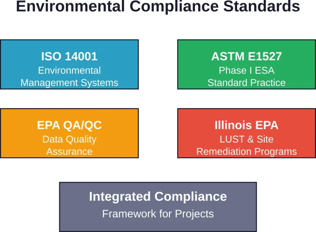
ISO 14001 provides the globally recognized framework for environmental management systems. According to ISO research, surveyed organizations perceived ISO 14001 as having high or very high value for meeting legal requirements. The same percentage found it valuable for improving environmental performance.
While A3 Environmental hasn’t publicly disclosed ISO certification status, their systematic approach to project management, quality control, and regulatory compliance reflects the principles embedded in ISO 14001:2015. The standard emphasizes understanding environmental context, identifying stakeholder needs, establishing clear objectives, and maintaining documented processes—all visible in A3’s project profiles and methodology descriptions.
ISO 14090:2019 addresses adaptation to climate change, an emerging consideration for environmental consultants evaluating long-term site risks, flood hazards, and ecosystem resilience in restoration projects. ISO 20700:2017 provides guidelines for management consultancy services, establishing professional service delivery expectations applicable to environmental consulting engagements.
Client Communication and Reporting
Environmental consulting serves distinct client segments: commercial real estate buyers conducting due diligence, property owners managing contamination, developers navigating wetland permits, municipalities planning infrastructure, and utilities maintaining compliance.
Each audience requires different communication approaches. Real estate attorneys need concise executive summaries highlighting liability risks. Lenders want clear answers on environmental conditions affecting collateral value. Regulatory agencies demand technical detail and data tables supporting compliance demonstrations.
Digital tools enable tailored reporting. Formsite data exports into standardized report templates. Bluebeam markups create visual documentation of site conditions for non-technical stakeholders. CADD-generated site plans provide the scaled drawings engineers and regulators expect.
A3 Environmental’s knowledge base demonstrates their client education approach. They publish sample reports, methodology explanations, and regulatory guidance for lenders, lawyers, and commercial real estate professionals—translating technical environmental work into business decision-making context.
Cost Considerations and Tool Selection
Environmental consulting firms face pressure to deliver quality work at competitive prices. Technology costs directly impact project budgets and firm profitability.
A3’s choice of Formsite at $15 monthly represents pragmatic cost management. Enterprise environmental data management systems can cost thousands per month—prohibitive for small to mid-sized consulting firms handling dozens rather than hundreds of concurrent projects.
The same cost-consciousness appears in Bluebeam adoption across the broader architecture and engineering community. It provides markup and collaboration capabilities without the expense of full document management platforms designed for large organizations.
This lean technology strategy aligns with competitive realities in environmental consulting. Phase I ESA pricing remains relatively standardized across providers, leaving little margin for expensive software overhead.
Freelance Consultant Support
A3 Environmental created tools specifically to support freelance environmental consultants—professionals building independent practices or supplementing firm employment with side projects.
Their Phase I ESA checklist and methodology documentation provide templates that freelancers can adapt. This reflects broader industry dynamics where experienced consultants increasingly operate as independent contractors rather than traditional employees, leveraging affordable cloud tools to compete with established firms.
| Tool Category | Example Platform | Monthly Cost Range | Primary Use Case |
|---|---|---|---|
| Form Builder | Formsite | $15 – $50 | Site questionnaires, data collection |
| PDF Collaboration | Bluebeam Revu | $200 – $350 (one-time) | Drawing markup, consultant coordination |
| GIS Software | QGIS (open source) | Free | Spatial analysis, wetland mapping |
| CADD Platform | AutoCAD LT | $55 – $75 | Site plans, technical drawings |
Geographic Focus and Local Expertise
A3 Environmental concentrates service delivery in Northern Illinois, with headquarters in Lisle. This regional focus creates specific advantages.
Local consultants develop relationships with Illinois EPA project managers, understand Office of the State Fire Marshal procedures, and know municipal engineering departments across the region. They recognize local geology, hydrology patterns, and industrial history that inform site assessments.
Technology enables this local expertise to scale efficiently. Digital checklists codify knowledge about Illinois-specific regulatory requirements. GIS databases maintain local reference layers—soil surveys, wetland inventories, historical aerial imagery—that accelerate new project startup.
Metropolitan Water Reclamation District of Greater Chicago represents one notable client relationship, demonstrating the trust public agencies place in A3’s capabilities for complex water quality and ecological projects.
Future Technology Trends in Environmental Consulting
Environmental consulting technology continues evolving. Emerging capabilities likely to influence A3 Environmental’s toolkit over the next several years include:
- Mobile field data collection platforms that replace paper forms with tablet-based applications capturing photos, GPS coordinates, and observations in standardized formats automatically syncing to office databases.
- Drone aerial imagery for site reconnaissance, wetland boundary documentation, and construction monitoring—providing cost-effective alternatives to traditional aerial photography.
- Cloud-based analytical databases that maintain complete project histories, track contaminant trends across multiple sampling events, and generate automated compliance reports for regulatory submissions.
These technologies share common characteristics: they reduce manual data handling, improve accuracy, accelerate project timelines, and lower costs. The same selection criteria that led A3 to adopt Formsite and Bluebeam will guide future technology investments.
Frequently Asked Questions
A3 Environmental uses Formsite, a cloud-based form builder costing $15 per month. This platform handles both Phase I ESA User Questionnaires and owner questionnaires, enabling digital data collection that eliminates handwritten notes and accelerates report preparation. Formsite’s conditional logic adapts questions based on previous responses.
The firm uses Bluebeam Sessions for multi-party document collaboration. This platform creates shared repositories where teams review drawings, add markups, and comment in real time. Bluebeam’s overlay functionality allows extracting portions of site plans and layering them onto environmental reports and maps.
A3 provides dedicated CADD and GIS consulting services for spatial analysis, site mapping, and environmental data visualization. These technologies support wetland delineation, stream restoration planning, contamination modeling, technical drawings for remediation systems, and UST removal plans.
A3 Environmental focuses primarily on Northern Illinois, with headquarters in Lisle. This regional concentration enables deep local expertise with Illinois EPA procedures, OSFM regulations, and relationships with municipal agencies across the region.
Core services include Phase I and Phase II Environmental Site Assessments, environmental remediation, underground storage tank removal and compliance audits, wetland delineation, ecological restoration, soil management, and environmental support services for commercial real estate, utilities, and municipal clients.
Phase I ESA pricing varies based on site size, complexity, historical use, and project timeline. Contact A3 Environmental directly at (888) 405-1742 for project-specific pricing. Their website provides contact information for staff scientists and project managers who can provide detailed proposals.
A3 Environmental employs environmental scientists, staff scientists, and a Lead Ecologist with M.S. credentials. Specific qualifications vary by team member; their website lists individual staff members with direct contact information for discussing project needs and consultant expertise.
Conclusion
A3 Environmental Consultants demonstrates how strategic technology selection amplifies environmental consulting effectiveness. Rather than chasing expensive enterprise platforms, they’ve assembled affordable, specialized tools that integrate seamlessly into project workflows.
Formsite handles critical data collection. Bluebeam enables consultant coordination. CADD and GIS platforms provide spatial analysis capabilities. Together, these tools support systematic project delivery across Phase I ESAs, UST compliance work, wetland delineation, and environmental remediation.
The approach reflects practical realities in environmental consulting—where project budgets demand efficiency, regulatory compliance requires documentation rigor, and client service depends on timely, accurate deliverables.
For freelance environmental consultants, commercial real estate professionals, or organizations seeking environmental services in Northern Illinois, understanding A3’s methodology and technology provides insight into modern environmental consulting practices. Visit A3E.com to explore their knowledge base, review project profiles, or contact their team about specific environmental assessment and compliance needs.