

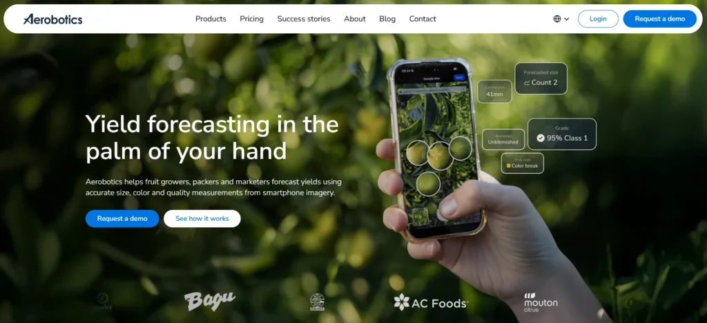
Quick Summary: Aerobotics is an AI-powered agricultural technology platform offering drone-based crop monitoring and disease detection services for fruit growers. The platform combines aerial imaging with machine learning to provide actionable insights on tree health, pest detection, and spray optimization, with a guaranteed 99.5% uptime SLA and deployment across Australia, New Zealand, the US, Europe, and South Africa.
Precision agriculture has reached a tipping point. Growers can’t rely on gut instinct alone anymore—not when drone technology and AI can spot disease weeks before the human eye catches it. Aerobotics sits at the intersection of these technologies, promising to transform how orchards and vineyards manage crop health.
But does it actually deliver? This review digs into the platform’s capabilities, limitations, and real-world performance to help growers decide whether it’s worth the investment.
What Is Aerobotics and Who Operates It
Aerobotics operates through three distinct legal entities depending on jurisdiction. For CMA-based operations (South Africa, Namibia, Lesotho, Swaziland), Aerobotics Proprietary Limited handles the data. US, European, and other territories fall under Aerobotics US, Inc. Australia and New Zealand have a dedicated regional entity.
This structure matters because service terms, data residency, and support channels vary by region. The platform itself remains consistent, but the contractual framework adapts to local requirements.
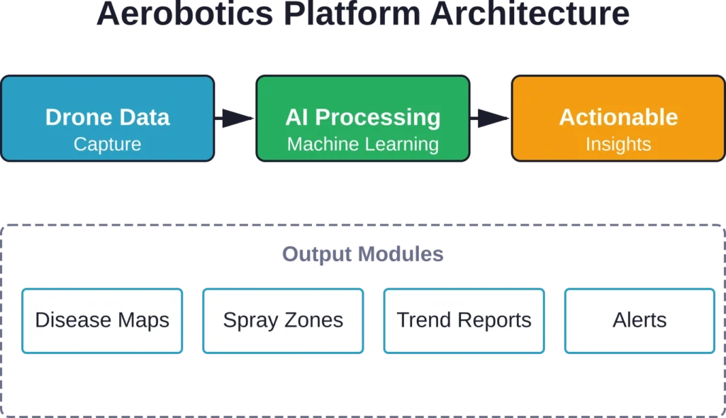
At its core, Aerobotics is a web platform and mobile application that processes aerial imagery to identify crop health issues. The system works with drone-captured data—either from growers’ own flights or contractor services—and runs it through machine learning models trained on specific pest and disease signatures.
Core Features and Capabilities
The platform is divided into several functional modules. Tree health monitoring forms the foundation, with AI models trained to detect early signs of stress, nutrient deficiency, and disease in individual trees.
Here’s what stands out: the system doesn’t just flag problems. It quantifies severity, maps distribution patterns, and tracks changes over time. That temporal component turns snapshots into trend data.
Disease Detection and Identification
The AI models target specific pathogens and pests common to tree crops. Citrus greening, false codling moth, and various fungal infections show up in the training datasets. Detection happens at the individual tree level, which matters when deciding whether to treat an entire block or just isolated problem areas.
Accuracy depends heavily on image quality and flight parameters. The system needs consistent lighting, proper overlap between images, and sufficient ground resolution to distinguish between similar-looking issues.
Spray Optimization Insights
According to competitor content, after a season in the field, growers report seeing spray benefits through targeted application. The platform generates prescription maps that mark which trees need treatment and which don’t. That level of granularity wasn’t practical before drone monitoring became routine.
Traditional block-wide spraying treats healthy trees alongside diseased ones. Aerobotics flips that approach by identifying the precise trees requiring intervention. The chemical cost savings can offset subscription fees, though actual returns depend on disease pressure and commodity prices.
Service Level and Performance Guarantees
Aerobotics commits to 99.5% uptime per calendar month, excluding scheduled maintenance. That’s the official Service Level Agreement documented in their terms of service (last updated 24 April 2026).
Real talk: agricultural operations have tight windows. Missing a critical spray window because the platform is down creates cascading problems. The 0.5% allowable downtime translates to approximately 3.6 hours per month. For most growers, that’s acceptable if outages don’t cluster during harvest or critical treatment periods.
The warranty also covers functionality—the platform must achieve the features described on the Order Form in all material respects. If it doesn’t, the sole remedy is that Aerobotics must use commercially reasonable efforts to fix the issue. That’s standard software warranty language, though it puts the burden on growers to document and report shortfalls.
Platform Access and Integration
The service runs through both web and mobile interfaces. Field scouts need the mobile app to ground-truth flagged trees and update status in real time. Farm managers and agronomists typically work from the web platform for analysis and reporting.
Data flows one direction initially—from drone to platform. But the real value emerges when outputs connect to other farm management systems. Prescription maps need to reach spray equipment. Treatment records should sync with compliance tracking. Yield estimates feed into harvest planning tools.
Integration capabilities matter here, though the terms of service don’t detail specific API access or third-party connections. That’s a question for the sales process and Order Form negotiation.
| Access Type | Primary Users | Key Functions |
|---|---|---|
| Web Platform | Farm managers, agronomists | Analysis, reporting, historical trends |
| Mobile App | Field scouts, supervisors | Ground verification, real-time updates, task management |
| Authorized Users | Extended team members | Role-based access to specific farms or data sets |
Data Ownership and Privacy Considerations
Farm data is sensitive. Yield trends, disease patterns, and operational details represent competitive intelligence. The terms of service establish that Aerobotics enters different legal agreements depending on where the grower operates, which affects data residency and jurisdiction.
For CMA-based operations (South Africa, Namibia, Lesotho, Swaziland), Aerobotics Proprietary Limited handles the data. US, European, and other territories fall under Aerobotics US, Inc. Australia and New Zealand have a dedicated regional entity.
The practical implication: understand which entity holds the contract before uploading farm data. Different jurisdictions have different rules about data access, portability, and government requests.
Comparison to Alternative Drone Platforms
Aerobotics isn’t the only player in agricultural drone analytics. Propeller Aero focuses on construction and earthworks but handles some agricultural mapping. Their photogrammetry services process drone data at scale, though the AI models target different use cases—volume calculations and site progress rather than pest detection.
Horizon Aerobotics targets infrastructure inspection, particularly railyards where machine learning spots derailment risks. Their technology demonstrates how drone-based AI can identify problems before they escalate—similar conceptually to what Aerobotics does for crops, but in an entirely different domain.
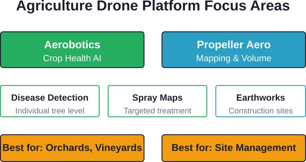
The differentiation comes down to AI training data. Aerobotics models learn from thousands of labeled crop images showing disease progression. Generic mapping platforms process spatial data beautifully but lack the domain-specific intelligence to flag a citrus tree showing early greening symptoms.
Use FlyPix AI to Review Agricultural Areas from Above
Aerobotics is closely connected with agricultural monitoring and crop insights. FlyPix AI can support similar field-focused work by analyzing satellite, drone, and aerial imagery to detect objects, monitor vegetation, and review land conditions across farms or larger agricultural areas.
FlyPix AI can support agriculture and land monitoring tasks such as:
- Reviewing crop areas, vegetation patterns, and field boundaries
- Detecting visible objects, gaps, or changes across farmland
- Comparing aerial or satellite imagery over time
- Creating custom AI models for specific crop, land, or farm features
Contact FlyPix AI to discuss how geospatial image analysis can support agricultural monitoring and land review work.
Pricing Structure and Cost Considerations
Aerobotics pricing isn’t published openly. The terms of service reference an Order Form that specifies selected products and associated fees. This structure suggests custom pricing based on farm size, crop type, and service level.
For current pricing information, growers need to contact Aerobotics directly through their official channels. Expect the sales process to involve a farm assessment, demonstration, and proposal tailored to specific operational needs.
The value equation hinges on scale and disease pressure. A 500-hectare citrus operation facing endemic pest problems calculates ROI differently than a 50-hectare boutique vineyard with minimal issues. The platform makes most sense where targeted intervention saves enough on inputs or protects enough yield to justify the subscription cost.
Regional Availability and Support
The platform operates across five main regions with different entities managing each territory. This geographic spread reflects the global nature of fruit production but also introduces variability in support quality and feature rollout timing.
| Region | Operating Entity | Coverage Notes |
|---|---|---|
| Common Monetary Area | Aerobotics Proprietary Limited | South Africa, Namibia, Lesotho, Swaziland |
| Australia/New Zealand | Regional entity | Dedicated local operations |
| United States | Aerobotics US, Inc. | Continental US coverage |
| Europe | Aerobotics US, Inc. | EU and associated territories |
| Other territories | Aerobotics US, Inc. | Case-by-case availability |
Regulatory compliance varies by region, particularly around agricultural drone operations. The FAA governs US operations under Part 137 for agricultural aircraft, though most modern ag drones fall under Part 107 remote pilot rules. International operations face different frameworks—Australian Civil Aviation Safety Authority rules differ from South African CAA requirements.
Growers should verify that their drone operations comply with local regulations before implementing any monitoring platform. The technology works globally, but the legal permission to fly doesn’t.
Implementation Considerations
Getting value from Aerobotics requires more than subscribing. Farms need consistent drone flights, either through in-house pilots or contracted services. Image quality standards matter—garbage in, garbage out applies fully.
Ground-truthing forms the other critical piece. AI flags potential issues, but human scouts confirm diagnoses and check for false positives. That feedback loop improves model accuracy over time, but it demands dedicated field labor.
Training staff to interpret platform outputs takes time. The interface presents complex spatial data that agronomists grasp quickly but may overwhelm operations staff without GIS experience. Plan for onboarding and ongoing education.
Strengths and Limitations
Where Aerobotics excels: detecting early-stage problems that would otherwise go unnoticed until symptoms become obvious. The temporal tracking catches trends that spot checks miss. The prescription mapping enables precision that manual scouting can’t match at scale.
Where it struggles: complex disease presentations that look similar to other issues. The AI models work best on well-defined signatures but can generate false positives when multiple stressors overlap. Unusual weather patterns that change leaf appearance sometimes trigger incorrect flags.
The platform doesn’t replace agronomists. It extends their reach and focuses their attention. Think of it as a force multiplier rather than a substitute for expertise.
Who Should Consider Aerobotics
Large-scale tree crop operations gain the most. Orchards and vineyards spanning hundreds of hectares can’t feasibly scout every tree regularly. Drone monitoring makes comprehensive coverage practical.
Growers facing persistent disease pressure benefit from early detection. Finding infections weeks sooner allows intervention before widespread damage occurs. That’s particularly valuable for slow-moving diseases where early treatment dramatically improves outcomes.
Operations already flying drones should evaluate whether specialized AI delivers more value than generic mapping. If drones currently capture pretty pictures but don’t generate actionable insights, platforms like Aerobotics bridge that gap.
Smaller farms might struggle with the cost-benefit equation unless margins are exceptionally high or disease risk is severe. The technology scales best at commercial production levels.
Frequently Asked Questions
Aerobotics is primarily a software platform and service. Growers either use their own drone equipment or contract with service providers who fly and upload imagery. The platform processes data regardless of which compatible drone captured it.
The platform focuses on tree crops, particularly citrus and stone fruit. The AI models are trained on specific crop types and common diseases affecting those crops. Check with Aerobotics directly about coverage for specific varieties and growing regions.
Flight frequency depends on growth stage and disease pressure. Weekly flights during critical periods provide the temporal resolution needed to catch rapid changes. Monthly flights suffice for baseline monitoring in low-pressure situations. More frequent data improves trend detection but increases operational costs.
The mobile app may cache some data for field use, but full functionality requires internet connectivity for image upload and processing. Remote operations need reliable data connections or a workflow that accommodates delayed synchronization when returning to coverage areas.
Data ownership and retention policies should be clarified in the Order Form before signing. This varies by region and contract structure. Growers should specifically negotiate data export provisions and post-termination access during the sales process.
Cloud cover, wind, and extreme temperatures impact both flight feasibility and image quality. Optimal conditions include clear skies, minimal wind, and consistent lighting. The AI performs best on high-quality imagery captured under ideal conditions. Poor weather reduces detection accuracy.
Aerobotics hasn’t published hard minimums, but practical economics favor larger operations. The platform pricing and operational overhead make most sense at commercial scale. Contact Aerobotics directly to discuss whether the service fits smaller operations.
Final Assessment
Aerobotics delivers a specialized tool for a specific agricultural challenge: monitoring large-scale tree crop health at granular detail. The AI capabilities differentiate it from generic drone mapping platforms, and the guaranteed uptime SLA demonstrates operational commitment.
The value proposition scales with farm size and disease risk. Operations that can leverage targeted treatment recommendations to reduce input costs or protect high-value crops will see clearer ROI. Smaller farms or those with minimal disease pressure may not reach the economic threshold.
Data privacy and regional legal structures require careful attention during the contracting phase. Understanding which entity holds the data and under what jurisdiction matters for compliance and risk management.
The platform works best as part of an integrated pest management program, not as a standalone solution. Combining AI-detected flags with expert agronomic interpretation and timely field verification creates a system more powerful than any single component.
For qualifying operations, Aerobotics represents a significant step beyond manual scouting. For others, the technology may arrive ahead of the business case. Visit the official Aerobotics website to discuss specific farm requirements and current pricing.