
")
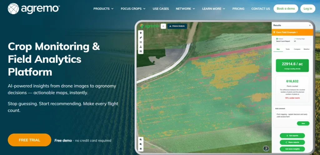
Quick Summary: Agremo is a cloud-based precision agriculture platform that transforms drone and satellite imagery into actionable crop insights using AI and computer vision. It helps farmers, agronomists, and researchers monitor crop health, detect weeds, analyze stand counts, and create variable-rate spraying maps—all from a single dashboard.
Farmers and agronomists face a constant challenge: making data-driven decisions quickly enough to protect yields. Drone technology has become increasingly accessible, but raw aerial imagery alone doesn’t tell the full story. That’s where Agremo comes in—a precision agriculture platform that bridges the gap between image capture and actionable field intelligence.
According to the University of Illinois Extension, drone mapping platforms can record conditions throughout the growing season, providing highly detailed comparisons of field performance year over year. Agremo leverages this capability by processing both drone-captured and satellite imagery through artificial intelligence and computer vision algorithms.
What Is Agremo?
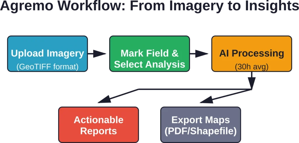
Agremo is a cloud-based field analytics software designed for professional growers, agricultural consultants, drone operators, seed companies, and fertilizer manufacturers. The platform processes georeferenced GeoTIFF images and delivers crop health reports, weed detection maps, stand count analyses, and variable-rate application prescriptions.
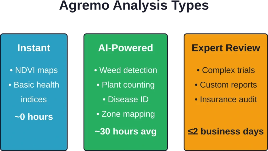
Users upload stitched imagery, mark their field boundaries, and select the analysis type they need. The platform handles the rest—AI models extract insights, and reports arrive within two business days on average (NDVI reports are instant). Delivery time for AI-powered analyses typically falls within a 30-hour window, though the service guarantees completion within two business days.
Core Products and Use Cases
Agremo organizes its capabilities into distinct product modules, each addressing specific agricultural workflows.
Crop Monitoring
This module tracks crop health across the entire growing season using both drone and satellite data. It includes NDVI (Normalized Difference Vegetation Index) mapping, weed detection, nutrient analysis, and disease identification. The platform offers unlimited stitching and analyses starting at $1,950 per year, making it accessible for operations of varying scales.
Field Trials
Designed for agricultural scientists and seed companies, the Field Trials module provides per-plot analytics. Researchers can compare treatment effects, measure plot-level variability, and generate statistical summaries for breeding programs or agrochemical evaluations.
Plant Counting
Stand count analysis helps determine emergence rates and plant population uniformity. According to community discussions, plant counting analysis takes approximately two business days to complete, which aligns with Agremo’s AI processing timeline for advanced analytics.
Zone Management and Spraying Tools
The platform creates spot and variable-rate application maps to reduce chemical use and cut costs. These prescription maps can be exported directly to spraying drones and machinery, enabling precision application based on actual field variability rather than blanket treatments.
| Product | Primary Use | Typical Users |
|---|---|---|
| Crop Monitoring | Season-long health tracking | Farmers, agronomists |
| Field Trials | Per-plot research analytics | Breeders, scientists |
| Plant Counting | Stand counts & emergence | Growers, consultants |
| Zone Management | Variable-rate prescriptions | Custom applicators, COOPs |

Add FlyPix AI to Agricultural Image Review
Agremo is used for agricultural analytics and drone-based crop monitoring. FlyPix AI can fit into related workflows when teams need to detect objects, segment field areas, and analyze satellite, drone, or aerial imagery for visible crop and land conditions.
FlyPix AI can support agriculture-focused image analysis tasks such as:
- Segmenting crop zones, vegetation areas, and field boundaries
- Detecting visible field changes, gaps, objects, or stressed areas
- Comparing aerial or satellite imagery over time
- Creating custom AI models for specific crop or land features
Reach out to FlyPix AI to discuss how geospatial image analysis can support your agricultural monitoring work.
Technology and Analytics Approach
Agremo combines three components: artificial intelligence, computer vision, and human expertise. AI models trained on thousands of field images recognize patterns in crop stress, weed pressure, and growth stages. Computer vision algorithms process spectral data beyond what the human eye can detect.
But here’s the thing—the platform doesn’t rely solely on automated outputs. Human agronomists review complex analyses to ensure accuracy, particularly for edge cases or unusual field conditions. This hybrid approach aims to balance speed with reliability.
Recommended Hardware and Setup
The platform doesn’t sell drones—it processes imagery from any source that produces georeferenced GeoTIFF files. Agremo recommends specific drones and cameras for optimal results, though the platform remains hardware-agnostic. Agremo supports both already stitched orthophotos (GeoTIFF) and raw georeferenced images, meaning users can upload unstitched photos directly to the platform for processing.
First-time setup involves logging into the web app, uploading imagery, marking field boundaries, and selecting the desired analysis type. The interface is browser-based, so no local software installation is required.
Who Uses Agremo?
The platform serves a diverse user base across the agricultural value chain. Farmers use it for in-season decision-making. Agronomists and consultants leverage it for multi-client reporting. Custom applicators create variable-rate maps for precision spraying equipment. Seed companies and agricultural cooperatives use the Field Trials module for research validation.
According to the FAO’s Science, Technology and Innovation Portal, Agremo is recognized as a cloud-based agricultural analytics platform that processes drone-captured imagery using artificial intelligence, computer vision, and machine learning for crop production and monitoring applications.
Practical Considerations
Real talk: the platform’s two-day turnaround for advanced analytics won’t suit every urgent scouting scenario. When a pest outbreak or weather event demands same-day decisions, instant NDVI maps provide some guidance, but detailed weed or disease reports require patience.
According to Reddit discussions in the UAV mapping community, processing time is a common consideration among users evaluating the platform. For operations that plan weekly or bi-weekly scouting flights, the timeline works well. For rapid-response situations, it’s less ideal.
The subscription model starts at $1,950 annually for Crop Monitoring with unlimited stitching and analyses. Pricing varies by product and usage level, so larger operations or those needing multiple modules should check the official site for current plans.
Frequently Asked Questions (FAQ)
Agremo is completely hardware-agnostic, meaning it can process imagery from any drone or satellite as long as the data is exported as a georeferenced GeoTIFF file. Agremo supports both already stitched orthophotos (GeoTIFF) and raw georeferenced images, meaning users can upload unstitched photos directly to the platform for processing.
Agremo’s subscription plans for the Crop Monitoring module start at $1,950 per year, which includes unlimited image stitching and analyses. Pricing for other modules, such as Field Trials or Stand Counts, varies based on your operation’s scale. Agremo offers a free trial for first-time users to test out the platform’s features on their own fields.
Yes. Through its Zone Management and Spraying Tools module, Agremo creates precise spot-spraying and variable-rate application (VRA) maps based on actual crop stress and weed density. These prescription maps can be exported directly into compatible spraying drones and smart machinery to help cut chemical and fertilizer costs.
Agremo uses a hybrid approach that combines artificial intelligence and computer vision algorithms with human expertise. While advanced AI models recognize patterns in crop health and weed pressure across thousands of trained field images, professional agronomists review complex or unusual edge cases to guarantee high report accuracy.
Absolutely. Agremo features a dedicated Field Trials module designed specifically for seed companies, agricultural scientists, and breeders. It provides highly detailed, per-plot analytics that allow teams to easily compare treatment effects, evaluate agrochemical performance, and track plot-level variability.
Conclusion
Agremo transforms aerial imagery into field intelligence that drives better agronomic decisions. Its AI-powered analytics go beyond basic vegetation indices, identifying weeds, counting plants, and creating prescription maps that reduce input costs. The platform’s cloud-based architecture and hybrid AI-human approach make it accessible for operations that lack in-house data science expertise.
For farmers, consultants, and researchers looking to extract maximum value from drone investments, Agremo offers a comprehensive toolkit—though the processing time for advanced analyses requires planning ahead. Check Agremo’s official website for a free trial and current feature availability for specific crops and regions.