

Quick Summary: Agrinavia is a mobile-first farm management software developed by Danish company Datalogisk A/S since 1987, designed to help farmers record field work, map weeds and drainage issues using GPS and camera functionality. Available on Google Play with 500+ downloads, Agrinavia MOBILE streamlines data collection in the field, eliminating the need for pen-and-paper notes and enabling precision farming practices through real-time documentation.
The agriculture industry has shifted dramatically toward data-driven decision making. Precision farming isn’t optional anymore—it’s becoming the standard for operations that want to stay competitive.
Agrinavia positions itself as a practical field-recording tool for farmers who need to document work without complicated setups or steep learning curves. But does it deliver on that promise?
This review breaks down everything about Agrinavia: what it does, who makes it, how the mobile app works, and where it fits in the broader precision farming landscape. No fluff, just the facts farmers need to make an informed choice.
What Is Agrinavia and Who Develops It?
Agrinavia is a farm and agribusiness management software brand developed by Datalogisk A/S, a Danish private limited company established in 1987. The company’s corporate identification number is 78871911, and its current status remains active as of March 2026.
Datalogisk A/S has been building agricultural software tools for nearly four decades, giving the company deep institutional knowledge of farming workflows and pain points. The Agrinavia brand specifically targets the mobile field-recording segment—a niche where traditional desktop farm management systems often fall short.
In 2024, SEGES Innovation took over the full ownership of Datalogisk, which has so far run as an independent subsidiary. This model often means slower feature rollouts but can also indicate product stability and long-term viability.
The Evolution of Farm Management Software
Farm management tools have evolved dramatically since Datalogisk first entered the market. Early systems focused on simple record-keeping—tracking inputs, yields, and basic financials.
Today’s precision farming landscape includes satellite imagery, AI-powered predictive analytics, IoT soil sensors, and variable rate technology that adjusts inputs based on real-time field conditions. The market now splits between comprehensive platforms that try to do everything and specialized tools that excel at specific tasks.
Agrinavia falls into the latter category. Rather than competing with full-featured platforms like Cropin or xFarm Technologies, it concentrates on making field data collection frictionless.
Agrinavia MOBILE: Core Features and Functionality
The Agrinavia MOBILE app, available on Google Play with a PEGI 3 rating, is the main mobile interface for field data collection. The app has accumulated 500+ downloads according to Google Play listing.
Here’s what the app actually does:
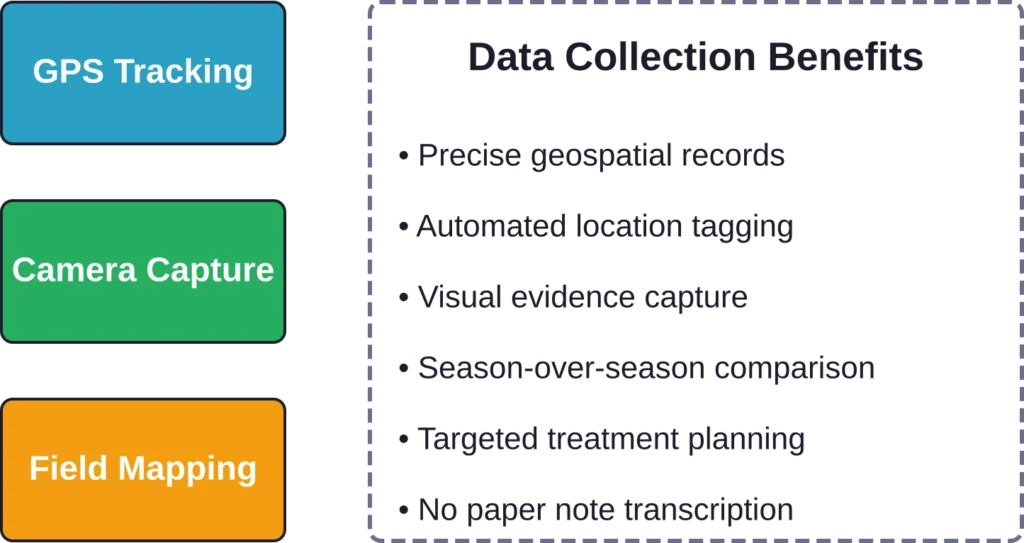
GPS-Based Field Recording
The app leverages smartphone GPS to automatically capture location data while farmers work. This eliminates manual coordinate entry and creates precise geospatial records tied to specific field zones.
Location tracking means every observation gets anchored to an exact spot. When farmers spot a weed patch, drainage problem, or rock outcropping, the GPS coordinates ensure they can find that exact location later—whether for treatment, equipment adjustments, or season-to-season comparison.
Camera Integration for Visual Documentation
Agrinavia MOBILE uses the phone’s camera to create visual records of field conditions. Farmers can photograph weeds, drainage issues, soil conditions, pest damage, or any other observable problem.
Visual documentation serves multiple purposes. It provides evidence for insurance claims, creates reference points for comparing field conditions across seasons, and helps communicate issues to agronomists or equipment operators who need to address specific problems.
Weed, Rock, and Drainage Mapping
The app specifically highlights three core use cases: mapping weeds, rocks, and drainage problems. These represent some of the most common field-variability issues that benefit from precise spatial recording.
Weed mapping supports targeted herbicide application—spray only where weeds actually exist rather than blanket-treating entire fields. Rock mapping helps equipment operators avoid damage and guides rock-picking operations. Drainage mapping identifies wet spots that need tile drainage or adjusted irrigation schedules.
Eliminating Pen and Paper
One of Agrinavia’s primary value propositions is removing the need to carry notebooks and clipboards into the field. Farmers no longer need to remember observations, jot them down, then transcribe them into a digital system later.
The smartphone becomes the single tool for capturing, storing, and organizing field observations. Everything syncs automatically, reducing the friction that often causes important observations to get lost or forgotten.
How Agrinavia Compares to Other Precision Farming Tools
The precision farming software market has expanded significantly. Dozens of platforms now compete for farmer attention, each emphasizing different capabilities and price points.
Understanding where Agrinavia fits requires comparing it to both comprehensive platforms and specialized mobile tools.
Comprehensive Platforms vs. Specialized Tools
Full-featured precision farming platforms like FlyPix AI, Cropin, and xFarm Technologies offer satellite imagery analysis, AI-powered predictive analytics, multi-platform access, and integration with drones and IoT devices. These systems aim to be the single source of truth for all farm data.
Agrinavia doesn’t try to compete in that space. It focuses narrowly on mobile field recording—doing one thing well rather than attempting comprehensive coverage.
This focused approach has trade-offs. Farmers get simplicity and ease of use, but they’ll likely need additional tools for satellite monitoring, yield analysis, or financial management.
Mobile-First Competitors
Other mobile-first farm management apps include OneSoil, Fasal, and portions of larger platforms like Farmers Edge. These tools similarly emphasize smartphone-based data collection but often bundle in cloud analytics or remote sensing features.
Agrinavia’s advantage lies in its streamlined interface and specific focus on visual documentation and GPS mapping. The app doesn’t overwhelm users with features they might not need, making it particularly suitable for smaller operations or farmers who already have other systems for analytics and planning.
| Tool | Primary Focus | Key Strength | Best For |
|---|---|---|---|
| Agrinavia | Mobile field recording | Simple GPS + camera mapping | Small to mid-sized farms needing field documentation |
| FlyPix AI | Comprehensive precision farming | AI analytics + drone integration | Operations wanting all-in-one platforms |
| OneSoil | Satellite monitoring | Free satellite imagery access | Budget-conscious farms needing remote sensing |
| Fasal | IoT + predictive analytics | Real-time sensor data + crop intelligence | High-tech operations with IoT infrastructure |
| EOSDA Crop Monitoring | Satellite-based field analysis | Detailed vegetation indices | Large farms needing comprehensive field analytics |
The Data-Driven Agriculture Context
Agriculture has shifted from “farming by instinct” to “farming by insight,” as industry observers noted in early 2026. The most important tool for agricultural engineers isn’t just a tractor anymore—it’s data.
Precision agriculture transforms fields into high-tech hubs where multispectral sensors identify nitrogen deficiencies and pest outbreaks 72 hours before human eyes detect problems. Variable Rate Technology (VRT): Why spray the whole field? Sensors now tell sprayers to apply inputs only where needed. Result? Up to 30% less waste and potential yield increases in some implementations.
IoT soil sensors send real-time alerts to automated irrigation systems, conserving water. AI systems analyze weather patterns, soil data, and market prices to optimize planting and harvest timing.
Within this broader ecosystem, tools like Agrinavia serve as the human-scale data input layer. While satellites and sensors capture what’s observable from above or below ground, mobile apps capture what farmers see walking the field—observations that automated systems can’t make but that remain critical for holistic farm management.
Review Farm Areas with FlyPix AI
Agrinavia is connected with farm planning, field records, and agricultural management. FlyPix AI can add a visual layer to this work by helping teams analyze satellite, drone, and aerial imagery to review field boundaries, visible land conditions, and site features from above.
FlyPix AI can help with image-based agricultural review tasks such as:
- Mapping field boundaries, roads, vegetation, and visible farm assets
- Detecting objects or visible changes across aerial and satellite imagery
- Segmenting crop zones, land areas, or infrastructure from imagery
- Training custom AI models for specific farm or land features
Contact FlyPix AI to discuss how geospatial image analysis can support farm and land review workflows.
Agrinavia Pricing and Plans
Specific pricing information for Agrinavia doesn’t appear in current public sources. The Google Play listing doesn’t show an upfront purchase price, suggesting either a freemium model, subscription pricing, or enterprise licensing.
For current pricing details, farmers should contact Datalogisk A/S directly or check the official Agrinavia website. Pricing structures in farm management software vary widely—from free tools with paid upgrades to enterprise packages based on farm size and feature requirements.
Many precision farming tools use tiered pricing. For context, comparable solutions range from free (OneSoil’s basic satellite monitoring) to €200/year for mid-tier plans (like some satellite-based monitoring services) to thousands annually for comprehensive enterprise platforms.
Value Proposition for Different Farm Sizes
Small farms often benefit most from simple, low-cost tools that solve specific problems without requiring extensive training or integration work. Agrinavia’s mobile-first approach fits this profile—minimal setup, immediate utility, and focused functionality.
Mid-sized operations might use Agrinavia as a complement to other systems, handling field-level data collection while separate platforms manage satellite imagery, yield analysis, and financial tracking.
Large farms with dedicated IT staff and complex tech stacks might find Agrinavia too limited unless it integrates well with their existing enterprise systems. The lack of public API documentation or integration details makes this assessment difficult without direct vendor contact.
Real-World Use Cases and Applications
Understanding how farmers actually use Agrinavia reveals its practical value beyond feature lists.
Weed Management and Herbicide Optimization
Mapping weed locations enables precision herbicide application. Instead of treating entire fields uniformly, farmers can create prescription maps that direct sprayers to apply herbicide only where weeds exist.
This approach reduces chemical costs, minimizes environmental impact, and helps manage herbicide resistance by limiting unnecessary exposure. The GPS and camera features let farmers document weed species, density, and spread patterns over multiple growing seasons.
Equipment Protection Through Rock Mapping
Rocks damage expensive tillage and harvest equipment. Mapping rock locations helps operators avoid problem areas or prioritize rock-picking operations where they’ll provide the most value.
Visual documentation also helps when coordinating rock removal—photos show contractors exactly what they’re dealing with before they arrive, improving quote accuracy and operational planning.
Drainage Problem Identification
Wet spots in fields indicate drainage problems that reduce yields and complicate field operations. Documenting these areas with GPS coordinates and photos supports tile drainage planning and irrigation system adjustments.
Over time, drainage mapping reveals patterns—which areas consistently hold water, how problem zones change with different weather patterns, and whether drainage interventions actually solved the problems they targeted.
Agronomist Communication and Collaboration
When farmers need to consult crop advisors or agronomists about field problems, precise location data and visual documentation streamline communication. Rather than describing “the northwest corner near the old oak tree,” farmers can share exact coordinates and photos showing the problem clearly.
This precision improves the quality of agronomic advice and reduces the need for multiple field visits, saving both time and consultant fees.
Technical Considerations and Integration
Farm management software doesn’t exist in isolation. Most operations use multiple tools, and integration capabilities determine whether a new app simplifies workflows or creates additional data silos.
Mobile App Requirements and Compatibility
Agrinavia MOBILE runs on Android devices via Google Play. The app requires unrestricted internet access according to its Play Store listing, suggesting it syncs data to cloud storage rather than operating purely offline.
Internet dependency can be a limitation in rural areas with spotty cellular coverage. Farmers working in remote fields might experience sync delays or need to wait until they return to areas with connectivity before data uploads complete.
No iOS version appears in current public information, which may limit adoption for farmers using iPhones or iPads. The Android-only approach is common among agricultural software from European developers but can be a dealbreaker for operations standardized on Apple devices.
Data Ownership and Export
Farm data represents valuable intellectual property. Understanding who owns the data, how it’s stored, and whether farmers can export it in standard formats matters for long-term planning.
Public documentation doesn’t clearly address these points for Agrinavia. Farmers evaluating the tool should clarify data ownership terms, export options, and what happens to stored data if they discontinue the service.
Integration With Other Farm Management Systems
The precision farming ecosystem increasingly relies on data flowing between specialized tools. GPS guidance systems, yield monitors, soil sampling equipment, and satellite imagery platforms all generate data that becomes more valuable when combined.
Whether Agrinavia integrates with other platforms—and which ones—isn’t clear from available public information. The lack of documented API access or partnerships with other ag-tech providers suggests limited integration capability, though direct vendor inquiry might reveal options not publicly advertised.
Strengths and Limitations
Every tool has trade-offs. Understanding Agrinavia’s strengths and limitations helps farmers determine whether it fits their specific needs.
Key Strengths
- Simplicity and ease of use: Agrinavia focuses on doing a few things well rather than overwhelming users with features. This makes it accessible for farmers who don’t want to invest extensive time in software training.
- Mobile-first design: Built specifically for field use rather than adapted from desktop software, the mobile interface reflects the realities of outdoor data collection.
- GPS and camera integration: Leveraging smartphone capabilities that farmers already carry eliminates the need for specialized hardware.
- Established developer: Datalogisk A/S has operated since 1987, suggesting stability and institutional knowledge that newer ag-tech startups lack.
- Targeted use cases: Specific focus on weeds, rocks, and drainage addresses common pain points that general-purpose farm management systems often handle poorly.
Potential Limitations
- Limited public information: Sparse documentation makes it difficult to evaluate features, pricing, and capabilities without direct vendor contact.
- Android-only availability: No iOS version excludes iPhone and iPad users from the ecosystem.
- Integration uncertainty: Unclear whether data flows easily to other farm management platforms or remains siloed within the Agrinavia ecosystem.
- Internet dependency: Requiring connectivity for full functionality can be problematic in areas with poor cellular coverage.
- Narrow feature set: Farms needing comprehensive management tools will require additional software for yield analysis, financial management, and satellite monitoring.
| Aspect | Strength | Limitation |
|---|---|---|
| User Interface | Simple, focused, minimal learning curve | Lacks advanced features power users expect |
| Platform Support | Optimized for Android field use | No iOS version available |
| Functionality | Excellent GPS + camera field recording | Doesn’t include satellite imagery or analytics |
| Integration | Standalone tool works independently | Unclear data export and API options |
| Company Background | Nearly 40 years of agricultural software experience | Limited marketing and public documentation |
| Connectivity | Cloud sync preserves data across devices | Requires internet access for full functionality |
The Broader Precision Farming Context in 2026
Agrinavia exists within a rapidly evolving precision agriculture landscape. Understanding broader trends helps contextualize where mobile field-recording tools fit.
The Shift to Data-Driven Agriculture
Data-driven agriculture is no longer optional—it’s becoming standard practice. The global agricultural tractors market size was valued at 2,765.3 thousand units in 2021 and is projected to reach 4,968 thousand units, driven by mechanization needs, labor shortages, higher productivity demands, and adoption of smart farming technologies across developed and emerging regions.
Farmers increasingly use drones with multispectral sensors to identify problems before they become visible to the human eye. Variable rate technology reduces input waste while improving yields. IoT sensors in soil send real-time alerts to automated irrigation systems, conserving water resources.
AI systems now analyze weather patterns, soil data, and market prices to optimize decision-making. The “smart farm” runs on data orchestration, integrating inputs from multiple sources into actionable intelligence.
Market Evolution and Competition
The precision farming software market has become crowded. Major players include established platforms and emerging AI-focused solutions:
- FlyPix AI offers comprehensive precision farming with real-time crop health monitoring, AI-powered predictive analytics, and seamless integration with drones and IoT devices
- OneSoil provides satellite-based field monitoring with free access to basic features
- Fasal focuses on IoT sensors and precision farming intelligence
- Farmers Edge combines satellite imagery with agronomic modeling
- Cropin delivers cloud-based farm management and intelligence
- EOSDA Crop Monitoring specializes in satellite-based vegetation analysis
- Farmonaut offers affordable satellite monitoring for smaller operations
Within this competitive landscape, Agrinavia’s mobile field-recording niche remains relevant. While comprehensive platforms try to be everything to everyone, specialized tools that solve specific problems well, continue to find adoption among farmers who prefer best-of-breed approaches over all-in-one solutions.
Regional Adoption Patterns
Precision agriculture adoption varies significantly by region. Developed agricultural economies like Denmark (where Agrinavia originates), the United States, and Australia show higher adoption rates of digital farming tools.
Emerging markets are catching up rapidly. Countries like Bangladesh are shifting toward precision farming to address decreasing arable land and climate volatility. Climate-smart engineering represents the path to sustainable food security in regions where agricultural inefficiency carries severe consequences.
European agricultural software tends to emphasize regulatory compliance and environmental sustainability alongside productivity improvements, reflecting the EU’s stricter agricultural environmental regulations.
Getting Started With Agrinavia
Farmers interested in trying Agrinavia can download the mobile app from Google Play. The 500+ downloads suggest a modest but established user base.
Before committing to any farm management software, consider these evaluation steps:
Assess Your Specific Needs
Identify exactly what problems need solving. If field-level observation recording is the primary pain point and current methods rely on paper notes or memory, a focused tool like Agrinavia might be ideal.
If needs extend to satellite monitoring, yield analysis, financial tracking, or comprehensive farm planning, a more full-featured platform makes more sense—either instead of or in addition to a specialized mobile recording tool.
Verify Device Compatibility
Confirm that Android devices are available and that cellular coverage in working areas supports the app’s internet requirements. Test connectivity in actual field locations before relying on cloud-synced data collection.
Clarify Pricing and Terms
Contact Datalogisk A/S directly for current pricing information. Ask about subscription models, per-farm licensing, feature limitations in different tiers, and any setup or training costs.
Test Data Export and Integration
Before collecting significant amounts of data, verify how information can be exported. Ask about supported file formats, whether data can move to other platforms, and what happens to stored information if the service is discontinued.
Start With a Pilot
Test the app on a portion of the operation before rolling it out farm-wide. Identify workflow issues, assess ease of use for all team members who’ll use it, and verify that the data collected actually supports better decision-making.
Alternative Tools Worth Considering
Depending on specific needs and farm characteristics, several alternatives might fit better than Agrinavia:
- For budget-conscious operations: OneSoil provides free satellite monitoring that covers basic remote sensing needs without subscription costs.
- For comprehensive platforms: FlyPix AI’s offers satellite indices, field comparison, and histogram visualization.
- For IoT integration: Fasal specializes in sensor-based precision farming with real-time crop intelligence.
- For large-scale operations: EOSDA Crop Monitoring and Farmers Edge provide enterprise-grade satellite and analytics capabilities.
- For emerging markets: Farmonaut offers affordable satellite monitoring designed for resource-constrained operations.
The right choice depends on farm size, technical sophistication, existing systems, budget constraints, and specific operational priorities. Many farms use multiple tools in combination, selecting best-in-class solutions for different aspects of farm management.
Frequently Asked Questions
Agrinavia is a mobile app that helps farmers record field work using their smartphone’s GPS and camera. It specializes in mapping weeds, rocks, and drainage problems, eliminating the need for paper notes and creating precise geospatial records of field observations.
Specific pricing information isn’t publicly available in current sources. Farmers should contact Datalogisk A/S directly or check the official Agrinavia website for current pricing plans and subscription options. Pricing structures vary widely in farm management software from free to hundreds of euros annually.
Based on available information, Agrinavia MOBILE appears to be Android-only, available through Google Play. No iOS version is documented in current public sources, which may limit adoption for operations using Apple devices.
Integration capabilities aren’t clearly documented in public sources. Farmers evaluating Agrinavia should ask Datalogisk A/S directly about data export options, API availability, and compatibility with other precision farming platforms they currently use.
The app requires unrestricted internet access according to its Google Play listing, suggesting cloud sync functionality. This may mean limited offline capability, which could be problematic in fields with poor cellular coverage. Farmers should test connectivity in actual working areas before depending on the app for critical data collection.
Agrinavia is developed by Datalogisk A/S, a Danish private limited company founded in 1987. The company has nearly four decades of experience building agricultural software tools, suggesting stability and deep knowledge of farming workflows.
Agrinavia focuses narrowly on mobile field recording rather than trying to provide comprehensive farm management. It excels at GPS and camera-based observation capture but doesn’t include satellite imagery, AI analytics, or financial management features. Farms often use Agrinavia alongside other tools rather than as a complete replacement for full-featured platforms.
Conclusion: Is Agrinavia Right for Your Operation?
Agrinavia represents a straightforward approach to a specific precision farming challenge: capturing field observations accurately and efficiently without complicated systems or extensive training.
The tool shines for operations that need better field-level documentation, particularly for weed mapping, rock identification, and drainage problem tracking. Its mobile-first design and GPS-plus-camera approach eliminate paper notes and create spatially precise records that support targeted interventions.
But it’s not for everyone. Farms needing comprehensive management platforms with satellite monitoring, yield analysis, and financial tracking will find Agrinavia too limited on its own. The Android-only availability excludes iOS users, and unclear integration capabilities may create data silos for operations using multiple systems.
The nearly four-decade track record of Datalogisk A/S suggests stability and agricultural domain expertise that many newer ag-tech startups lack. Yet the limited public documentation and modest download numbers indicate a tool that hasn’t achieved widespread market penetration despite its long history.
For small to mid-sized farms seeking a simple, focused tool for field observation recording, Agrinavia merits evaluation. Download the app, test it in actual field conditions, and verify it solves your specific problems before committing.
The precision farming landscape continues evolving rapidly. Tools that excel at specific tasks while integrating well with broader ecosystems will likely thrive. Whether Agrinavia fits that description for your operation depends on your unique needs, existing systems, and operational priorities.
Check the official Agrinavia website for current features, pricing, and compatibility information. The right precision farming tools are the ones that actually get used—simplicity and fit often matter more than feature lists.