
Quick Summary: Aistech Space is a space technology company with operations including Barcelona, offering the ALEX platform for high-resolution thermal infrared satellite data. Following the launches of Hydra-2 and Hydra-3 satellites, they’ve begun delivering processed imagery through an API-first approach, targeting sectors like defense, disaster response, and climate monitoring.
Earth observation technology has evolved dramatically over the past decade. Yet thermal infrared data—critical for understanding heat signatures, wildfire monitoring, and environmental change—remains harder to access than visible-spectrum imagery.
That’s where Aistech Space enters the picture.
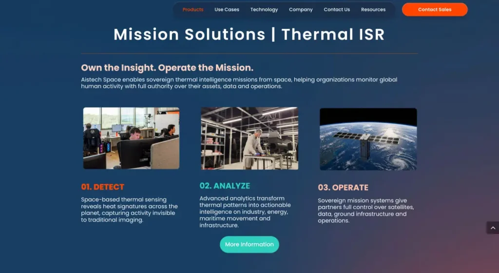
Three months after their Hydra-2 satellite launch, the company shared its first selection of images captured, processed, and georeferenced within the ALEX platform for Earth observation. The platform represents an API-first ecosystem designed to deliver high-resolution, high-frequency thermal infrared data to sectors ranging from security and defense to disaster response and climate research.
But does the platform live up to its promise? And what makes Aistech Space’s approach different from established players in the Earth observation market?
This review breaks down the ALEX platform’s capabilities, explores Hydra-2 and Hydra-3 early performance, examines the technology stack, and evaluates where the tool fits in today’s satellite data landscape.
What Is Aistech Space?
Aistech Space is a space technology company with operations including Barcelona, focused on building a comprehensive Earth observation ecosystem around thermal infrared satellite data. The company operates with 13,081 followers on LinkedIn as of the source publication date, indicating a growing presence in the space and defense sectors.
The company’s flagship offering—ALEX—serves as a centralized hub for satellite data exploitation. According to recent company announcements, ALEX enables users to discover archived imagery via STAC-compliant catalogs, request new acquisitions through a STAPI-aligned tasking service, and securely access both processed and raw data products including GeoTIFF formats through storage services.
The platform acts as middleware between satellite hardware and end users. Instead of requiring direct satellite ground station access or complex image processing pipelines, organizations tap into Aistech’s infrastructure through APIs or a web-based interface.
The Hydra Satellites
Hydra-2 and Hydra-3 represent Aistech Space’s initial operational satellites. Hydra-2, launched in January 2026, is the company’s second-generation satellite. Hydra-3, successfully launched on May 3, 2026 aboard a SpaceX Falcon 9, joined it as the second commercial satellite in the Hydra constellation. EnduroSat supported satellite platform commissioning, while FarEarth Labs delivered the first L1 and L2 products ahead of the CALVAL phase for the ENABLER thermal payload.
ALEX Platform Architecture
The ALEX platform follows a cloud-native architecture designed for multi-tenant access. Organizations can segment data and users through project management capabilities, ensuring secure access controls across different departments or client groups.
Here’s what sets ALEX apart from downloading raw satellite files from an FTP server:
- STAC-Compliant Catalogs: The SpatioTemporal Asset Catalog specification standardizes how geospatial data gets described and discovered. Instead of proprietary search interfaces, developers can use STAC-compatible tools across multiple data providers, including Aistech’s archive.
- STAPI-Aligned Tasking: The SpatioTemporal Asset Tasking Interoperability specification handles satellite tasking requests. Organizations can programmatically request new imagery acquisitions over specific areas at specific times, rather than emailing requests to an operations team.
- API-First Approach: Every function—catalog search, tasking requests, data downloads—exposes through RESTful APIs. Developers integrate satellite data into existing systems without manual downloads or bespoke file transfer protocols.
- Web Interface: For teams without developer resources, a web-based interface provides point-and-click access to the same catalog, tasking, and download capabilities.
Data Processing Pipeline
Raw satellite telemetry requires significant processing before it becomes useful imagery. Aistech’s pipeline converts sensor readings into georeferenced, calibrated products at multiple processing levels:
- L1 Products: Level 1 data includes radiometrically corrected imagery—sensor readings converted to physical units like radiance or brightness temperature, but not yet geometrically corrected to match Earth’s surface precisely.
- L2 Products: Level 2 processing adds geometric correction, orthorectification, and georeferencing. Images align to coordinate systems, allowing overlay with maps, GIS data, and other satellite imagery.
FarEarth Labs delivered both L1 and L2 products for Hydra-2 and Hydra-3 ahead of the calibration and validation phase. This partnership approach mirrors broader trends in the space industry—specialized companies handle specific pipeline stages rather than single organizations building everything in-house.
Core Platform Features
The ALEX platform bundles several capabilities that traditionally required separate tools or vendors. Organizations monitoring thermal data across security, defense, disaster response, or climate applications can access everything through one ecosystem.
Archive Discovery
Historical imagery becomes searchable through STAC-compliant catalogs. Teams can filter by location, time range, cloud cover, sensor parameters, and other metadata without learning proprietary query languages.
Standard geospatial tools—QGIS, ArcGIS, Python libraries like PySTAC—can directly query Aistech’s catalog alongside data from other STAC providers. This interoperability matters when building multi-source analysis pipelines.
Tasking Service
Requesting new satellite acquisitions typically involves emailing operations teams, waiting for feasibility analysis, and negotiating through procurement processes. STAPI-aligned tasking automates feasibility checks and booking through APIs.
Organizations can submit tasking requests programmatically, receive confirmation of acquisition windows, and get notified when data becomes available. The satellite captures imagery during its next pass over the requested area—assuming orbital mechanics, weather, and operational constraints align.
Data Access and Formats
Processed imagery downloads in GeoTIFF format—the industry standard for georeferenced raster data. GeoTIFF files embed coordinate system information directly, allowing immediate use in GIS software without manual georeferencing steps.
Storage services provide secure, multi-tenant access. Organizations control which users can access which datasets through project-based permissions. This matters for defense contractors, government agencies, and commercial operators who can’t risk data leakage across client boundaries.
Organization and Project Management
Cloud-native architecture supports multiple organizations on shared infrastructure. Each organization creates projects, assigns users, and manages data access independently.
Think of it as similar to AWS organizations and accounts—administrative boundaries prevent one customer from seeing another customer’s data, while shared infrastructure keeps costs lower than dedicated single-tenant deployments.
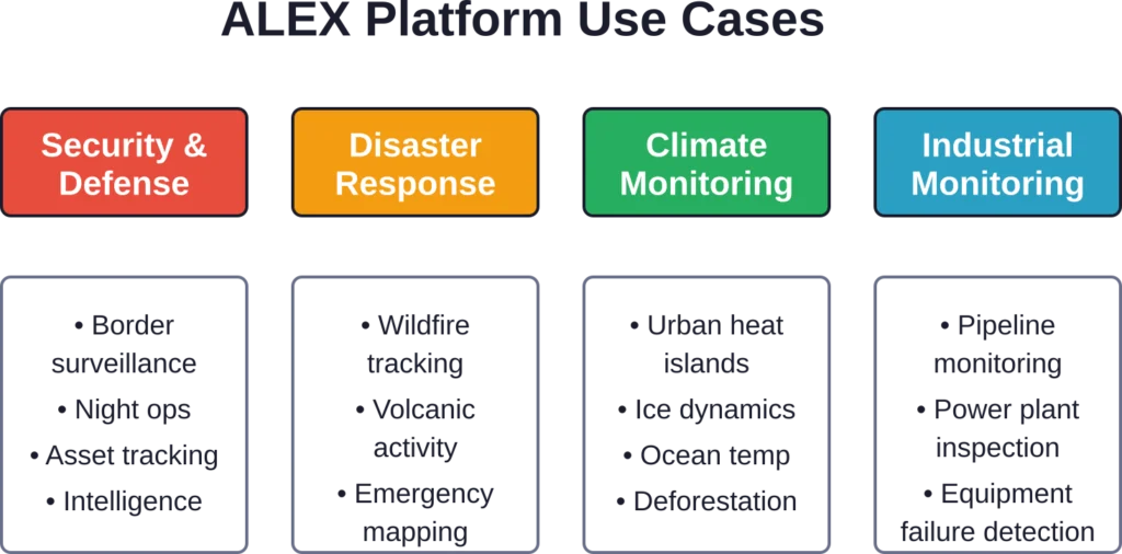
Target Use Cases
Thermal infrared data serves different purposes than visible-spectrum imagery. Heat signatures reveal information invisible to optical sensors, making the technology valuable for specific applications.
Security and Defense
Military and intelligence applications rely heavily on thermal data. Heat signatures identify vehicle movements at night, detect camouflaged installations, monitor border crossings in darkness, and track naval vessels by their thermal exhaust.
Aistech positions ALEX for security and defense stakeholders who need high-frequency thermal coverage. The API-first approach fits modern defense software architectures where analysts integrate multiple intelligence sources into unified dashboards.
Disaster Response
Wildfires generate intense heat visible through smoke and cloud cover. Thermal satellites detect fire fronts, map burn perimeters, and identify hotspots during active firefighting operations.
Volcanic activity, industrial accidents, and urban fires all produce thermal signatures. Response teams can task satellites for near-real-time data rather than waiting for next-day imagery from scheduled passes.
Climate Change Monitoring
Surface temperature measurements track urban heat islands, deforestation impacts, ice sheet dynamics, and ocean temperature patterns. Long-term thermal archives reveal warming trends invisible in shorter timeframes.
Climate researchers typically use government satellite data—Landsat, MODIS, Sentinel—which offer free access but limited temporal resolution. Commercial providers like Aistech promise higher revisit rates for critical areas, though at a cost.
Industrial and Infrastructure Monitoring
Power plants, refineries, and industrial facilities emit characteristic heat signatures. Monitoring thermal patterns can detect equipment failures, inefficient operations, or unauthorized activity.
Pipeline monitoring, solar farm inspection, and data center thermal management all benefit from periodic thermal imagery. Organizations can track performance over time and identify anomalies that indicate problems.
Competitive Landscape
Aistech Space operates in a crowded Earth observation market. Understanding where they fit requires comparing capabilities, business models, and target customers.
Government Satellite Programs
NASA’s Landsat program provides free thermal data at 100-meter resolution with 16-day revisit times. The European Space Agency’s Copernicus program offers Sentinel-3 thermal data at 1-kilometer resolution daily. These free resources serve research communities, government agencies, and non-profit applications.
Commercial operators compete on resolution, revisit frequency, and access patterns—not raw data availability. Organizations needing daily thermal coverage over specific assets can’t wait 16 days between Landsat passes.
Commercial Optical Providers
Planet Labs operates the largest commercial satellite constellation, capturing daily optical imagery at 3-5 meter resolution globally. Maxar Technologies provides sub-meter optical imagery for defense and intelligence applications. Neither focuses primarily on thermal data.
Optical and thermal sensors serve complementary purposes. Many organizations need both—visible imagery for feature identification and thermal data for heat signature analysis.
Thermal Specialist Competitors
Satellogic includes thermal sensors in its multi-spectral constellation. HawkEye 360 focuses on radio frequency monitoring rather than thermal. Several startups are building thermal-focused constellations, but few have reached operational scale as of mid-2026.
Aistech’s differentiation comes from the ALEX platform architecture and API-first approach rather than revolutionary sensor technology. The bet is that better data access matters more than incrementally better sensors.
Improve Earth Observation Image Analysis with FlyPix AI
Satellite-based monitoring depends on turning raw imagery into clear geospatial information that teams can classify, compare, and use. FlyPix AI supports analysis of satellite, drone, aerial, LiDAR, SAR, and multispectral imagery for detection, segmentation, classification, and change monitoring. For workflows related to Aistech Space, it can help teams work with Earth observation data by identifying visible features, segmenting areas, classifying land cover, and tracking changes across selected locations.
FlyPix AI can support Earth observation workflows with:
- Land cover and land use classification from satellite imagery
- Detection of visible surface features across mapped areas
- Area segmentation for environmental or infrastructure review
- Custom AI model training for specific geospatial analysis tasks
- Geospatial data sourcing and preparation
👉Contact FlyPix AI to discuss Earth observation image analysis for your geospatial project.
Technical Specifications
Detailed technical specifications remain limited in public announcements. The company hasn’t published comprehensive datasheets covering spatial resolution, temporal resolution, spectral bands, or pricing structures.
What we know from early 2026 announcements:
- Hydra-2 carries the ENABLER thermal payload
- Data products include GeoTIFF format outputs
- Processing reaches L1 and L2 levels
- The platform follows STAC and STAPI specifications
- EnduroSat provided satellite platform commissioning
- FarEarth Labs handles initial data product generation
For current technical specifications, spatial resolution, spectral bands, and orbital parameters, check Aistech Space’s official documentation or contact their sales team directly.
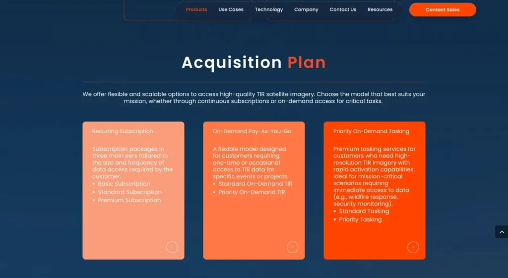
Pricing and Access
Aistech Space hasn’t published public pricing for ALEX platform access or Hydra-2 and Hydra-3 data. Enterprise Earth observation platforms typically use custom pricing based on usage volume, data freshness requirements, geographic coverage areas, and contract terms.
Common pricing models in the satellite data industry include:
- Per-image pricing for archived data
- Tasking fees for new acquisitions
- Subscription plans for regular coverage areas
- API call limits or data transfer fees
- Tiered access based on data processing levels
Organizations interested in ALEX platform access should contact Aistech Space directly for current pricing, trial programs, and contract options specific to their use case and data volume requirements.
Strengths and Limitations
Every Earth observation platform involves tradeoffs. Understanding what Aistech does well—and where challenges remain—helps organizations evaluate fit for their requirements.
Platform Strengths
- Modern API Architecture: STAC and STAPI compliance means standard tools work immediately. Development teams don’t need to learn proprietary interfaces or build custom integrations.
- Cloud-Native Infrastructure: Multi-tenant architecture, project-based access controls, and web interfaces match how organizations already work with cloud services. No ground station infrastructure or satellite operations expertise required.
- Thermal Data Focus: Specializing in thermal infrared fills a market gap. Organizations needing heat signature analysis don’t pay for excess visible-spectrum imagery they won’t use.
- Processing Pipeline: Delivering georeferenced L2 products means data arrives ready for analysis. Teams skip the radiometric correction and geometric processing steps that require specialized expertise.
Current Limitations
- Limited Public Information: Technical specifications, pricing, and performance benchmarks remain largely unpublished as of mid-2026. Organizations evaluating the platform need direct engagement with sales teams to get specifics.
- Single Satellite Operation: Hydra-2 and Hydra-3 are currently in orbit, forming the initial phase of the Hydra constellation. Revisit frequency over any specific location is still limited and depends on orbital parameters. Large constellations like Planet’s provide much higher revisit rates through satellite count.
- Early Stage Operations: The company shared the first imagery three months after launch. Calibration and validation phases typically take months to years. Mature operational status and long-term performance data aren’t yet available.
- Market Competition: Established players offer mature platforms, extensive archives, and proven reliability. New entrants need compelling differentiation beyond matching existing capabilities.
| Aspect | Strength | Limitation |
|---|---|---|
| API Architecture | STAC/STAPI compliance, modern RESTful design | Limited documentation on rate limits, performance |
| Data Processing | Automated L1/L2 pipeline, GeoTIFF outputs | CALVAL phase ongoing, full accuracy specs pending |
| Coverage | Thermal infrared specialization | Single satellite limits revisit frequency |
| Platform Maturity | Cloud-native, multi-tenant architecture | Early operational stage, limited track record |
| Pricing | Enterprise customization available | No public pricing, requires direct contact |
| Market Position | Growing presence, 13K+ professional network | Competing against established providers |
Who Should Consider ALEX?
Not every organization needs commercial thermal satellite data. Government programs provide free alternatives, and optical imagery serves many applications better. But specific use cases favor Aistech’s approach:
- Defense and Intelligence Contractors: Organizations building intelligence analysis systems that integrate multiple data sources benefit from API-first architecture. Security classifications and multi-tenant isolation matter for defense applications.
- Disaster Response Agencies: Wildfire management, volcanic monitoring, and emergency mapping teams need high-frequency thermal data during active events. Tasking capabilities for urgent acquisitions matter more than extensive archives.
- Climate Research Groups: Academic and government researchers studying thermal phenomena can augment free Landsat/Sentinel data with commercial imagery for critical areas requiring higher temporal resolution.
- Industrial Monitoring Services: Companies offering pipeline monitoring, infrastructure inspection, or facility management services can integrate satellite thermal data into broader monitoring platforms through APIs.
- Not a Good Fit For: Organizations needing only occasional imagery, projects with tight budgets favoring free government data, applications requiring visible spectrum or SAR rather than thermal, or teams without technical capacity to work with API-based platforms.
Integration Considerations
Technical teams evaluating ALEX should consider integration patterns, development requirements, and operational dependencies.
API Integration
STAC-compliant catalogs work with existing geospatial libraries. Python developers can use PySTAC, JavaScript applications can leverage STAC Browser, and GIS software with STAC support can directly query catalogs.
Authentication patterns, rate limits, and error handling details matter for production systems. Organizations should test API integration thoroughly during evaluation phases, not assume smooth operation based on specification compliance alone.
Data Volume and Storage
Thermal imagery files can reach gigabytes per scene depending on coverage area and resolution. Teams need appropriate storage infrastructure—S3 buckets, cloud storage, or local servers—sized for expected data volumes.
Processing pipelines may require compute resources for analysis beyond basic visualization. Change detection, thermal anomaly identification, and time-series analysis all demand significant processing depending on area coverage and temporal frequency.
Georeferencing and Coordinate Systems
GeoTIFF outputs include coordinate system information, but organizations should verify compatibility with existing GIS infrastructure. Reprojection may be necessary if internal systems use different coordinate reference systems than delivered data.
Vertical datums, ellipsoid models, and projection parameters all affect accuracy when overlaying multiple data sources. Geodesy details matter for precise applications like infrastructure monitoring or change detection.
Future Development and Roadmap
Based on company announcements and industry patterns, several development areas seem likely for Aistech Space, though official roadmaps haven’t been published:
- Constellation Expansion: With Hydra-2 and Hydra-3 now in orbit, Aistech is in the early phase of constellation deployment. The company plans to significantly expand the Hydra constellation (targeting dozens of satellites) to achieve higher revisit rates.
- Additional Sensors: Thermal-only data serves specific markets. Adding visible spectrum, SAR, or hyperspectral sensors would broaden applications and customer base, though at the cost of focus.
- Enhanced Processing: L1 and L2 products represent standard geometric and radiometric correction. Higher-level products—thermal anomaly detection, change detection, or application-specific analytics—add value for customers without in-house processing expertise.
- Partnership Ecosystem: Collaborations with EnduroSat and FarEarth Labs suggest a partnership model. Additional integrations with data marketplaces, GIS vendors, and application developers could accelerate adoption.
Frequently Asked Questions
Thermal infrared sensors detect heat emitted by objects rather than reflected sunlight. This allows imaging at night, through smoke or cloud cover in some conditions, and reveals temperature patterns invisible to optical cameras. Applications include wildfire detection, volcanic monitoring, heat loss from buildings, and nighttime surveillance.
Revisit frequency depends on orbital parameters and operational constraints. Aistech Space hasn’t published specific revisit times for Hydra-2 and Hydra-3. Single satellite systems typically achieve 3-7 day revisits for specific locations, while constellations can provide daily or sub-daily coverage. Contact Aistech directly for current operational revisit capabilities.
The platform uses STAC-compliant catalogs, which are designed for interoperability. Teams can query multiple STAC-compliant data sources—including government satellites, other commercial providers, and airborne imagery—using the same tools. However, data processing, tasking, and storage services appear specific to Aistech’s Hydra satellite data.
API access requires programming knowledge—typically Python, JavaScript, or other languages with HTTP client libraries. The web interface provides point-and-click access for non-developers. GIS experience helps for working with georeferenced imagery, coordinate systems, and spatial analysis. Organizations without internal technical capacity may need consulting support or managed services.
Aistech hasn’t published public pricing structures. Commercial satellite data pricing varies dramatically based on resolution, freshness, coverage area, and contract terms. Per-image pricing ranges from tens to thousands of dollars. Subscription models might cost thousands to hundreds of thousands annually depending on usage. Free government data from Landsat and Sentinel provides alternatives for applications tolerating lower resolution and revisit frequency.
Yes. GeoTIFF format outputs work directly in standard GIS software including ArcGIS, QGIS, and ERDAS IMAGINE. STAC-compliant catalogs integrate with modern GIS platforms supporting the specification. Organizations may need to verify coordinate system compatibility and configure authentication for API access, but the data formats follow industry standards.
Calibration and validation phases verify that sensor measurements match ground truth and meet accuracy specifications. Teams collect ground-based measurements, compare satellite readings to known targets, and adjust processing algorithms. This phase can take months to years for new sensors. CALVAL completion indicates readiness for operational data production with published accuracy specifications.
Final Verdict
Aistech Space enters the Earth observation market with modern architecture and thermal data specialization at a time when climate monitoring, disaster response, and defense applications drive demand for heat signature analysis.
The ALEX platform’s API-first approach matches how development teams build applications today. STAC and STAPI compliance means standard tools work immediately. Cloud-native infrastructure, multi-tenant access controls, and automated processing pipelines reduce operational friction compared to traditional satellite data workflows.
But the company operates in early-stage mode. Three months post-launch represents the beginning of operational capability, not proven long-term performance. Limited public information about resolution, pricing, and technical specifications requires direct engagement for serious evaluation. Single-satellite operations constrain revisit frequency compared to large constellations.
Organizations already committed to commercial satellite data and needing thermal capabilities should evaluate ALEX alongside established providers. The modern API architecture and thermal focus provide differentiation, but mature alternatives exist.
For teams just entering satellite data usage, free government programs offer lower-risk starting points. Landsat and Sentinel data provide thermal bands at no cost, though with lower temporal resolution. Organizations can graduate to commercial providers once requirements justify the investment.
Defense contractors, disaster response agencies, and industrial monitoring services represent the sweet spot—organizations with budgets for commercial data, technical capacity for API integration, and specific thermal data requirements that free alternatives don’t meet.
The platform shows promise. Modern architecture matters. Thermal specialization fills a market gap. But early-stage operations mean evaluation requires direct engagement, pilot programs, and realistic expectations about maturity and track record.
For current pricing, technical specifications, and trial program availability, visit Aistech Space’s official website or contact their sales team with specific use case requirements.