Understanding Terrain Classification: Methods, Applications, and Insights

Terrain classification is the process of categorizing and mapping different types of landscapes or surfaces based on their physical characteristics. While it might sound like a niche subject, this field has a surprisingly broad impact on engineering, transportation, urban planning, and even robotics. In essence, terrain classification lays the groundwork for how we build highways, […]
Railway Track Inspection: The Ultimate Guide for Safe and Efficient Operations

Railway track inspection is a critical part of modern transportation. Trains carry passengers and cargo across thousands of miles of tracks, and their safety depends on the condition of those rails. An undetected crack or weakened spot could lead to derailments that harm people, disrupt schedules, and cause financial losses. In this guide, we will […]
AI Feature Extraction: Techniques, Benefits, and Applications

AI feature extraction is a crucial step in machine learning that converts raw data into meaningful information for algorithms. Without proper feature extraction, AI models struggle with accuracy, efficiency, and interpretability. This process helps reduce dimensionality, remove redundant data, and enhance model performance. Feature extraction plays a critical role in various AI applications, including computer […]
A Comprehensive Guide to Land Cover Classification

Land cover classification might sound like a niche topic at first, but it touches many aspects of our lives. The way we categorize the Earth’s surface into forests, pastures, bodies of water, urban areas, and more affects everything from environmental protection to food security. In this guide, we’ll explore why land cover classification matters, how […]
UAV Aerial Inspection: A Comprehensive Guide for Modern Industries
Unmanned Aerial Vehicles (UAVs), commonly known as drones, are changing the way industries inspect, monitor, and manage assets. From towering skyscrapers to remote construction sites, UAVs are delivering safer, more efficient, and more accurate data than ever before. In this article, we’ll explore the fundamentals of UAV aerial inspection, its major benefits, the technology behind […]
Pipeline Monitoring: A Comprehensive Guide to Safety and Efficiency
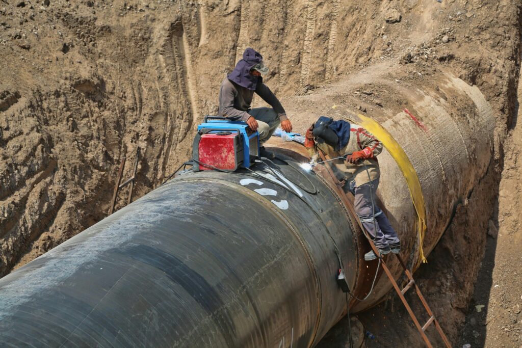
Pipeline monitoring is the practice of continuously observing pipelines to detect leaks, prevent failures, and ensure safe, efficient transport of vital resources. Whether these pipelines carry oil, gas, water, or chemicals, the consequences of a failure can be substantial. Monitoring programs reduce the risk of leaks and ruptures, minimize environmental harm, and help operators maintain […]
Understanding the Global Land Use Change Crisis: Causes, Impacts, and Solutions

Land use change—the transformation of natural landscapes for human purposes—is one of the most pressing yet overlooked environmental challenges of our time. From sprawling cities to industrial farms, humanity’s footprint on Earth has reshaped nearly one-third of the planet’s land surface in just six decades. But what does this mean for our future? In this […]
Exploring the Benefits and Applications of Reality Capture in Hobart

Reality capture technology has revolutionized industries by providing accurate 3D representations of environments through advanced scanning and imaging techniques. In Hobart, Tasmania, businesses and professionals are increasingly leveraging this technology for surveying, construction, and architectural design. This article explores how reality capture is utilized in Hobart and the significant benefits it brings to various sectors. […]
Reality Capture Pricing: What It Costs & How to Save

Reality Capture is changing the way we document and recreate real-world spaces, but it doesn’t have to break the bank. Whether you’re using LiDAR, drones, or photogrammetry, there are ways to cut costs while still getting high-quality results. In this guide, we’ll break down how much Reality Capture actually costs, what affects pricing, and how […]
Geospatial Companies in North Dakota

North Dakota is home to a growing number of geospatial companies that specialize in mapping, surveying, and geographic information systems (GIS). These companies support key industries in the state, including agriculture, energy, and urban planning. With services ranging from land surveying to advanced spatial data analysis, they play a crucial role in helping businesses and […]