
Reality capture technology has revolutionized industries by providing accurate 3D representations of environments through advanced scanning and imaging techniques. In Hobart, Tasmania, businesses and professionals are increasingly leveraging this technology for surveying, construction, and architectural design. This article explores how reality capture is utilized in Hobart and the significant benefits it brings to various sectors.
Applications of Reality Capture in Hobart
Reality capture technology has a wide range of applications across industries, and Hobart, with its unique geographical, cultural, and architectural landscape, stands to benefit immensely from these advancements. The ability to digitally capture and model real-world environments opens up possibilities for better planning, preservation, and development in a variety of sectors. Here, we explore the primary applications of reality capture technology in Hobart, including construction, heritage preservation, urban planning, and environmental monitoring.
Construction and Infrastructure Development
In Hobart, the construction industry can leverage reality capture technology for more efficient and accurate planning and development. The city’s infrastructure, including historical buildings, new developments, and challenging terrains, presents unique opportunities for the application of reality capture tools such as LiDAR and drones. These tools allow construction professionals to create detailed 3D models of sites, which can be used for everything from initial planning to quality control during construction.
- Site Surveys: Reality capture enables accurate site surveys that can be completed faster than traditional methods. This is especially useful for large, complex sites where traditional surveying would be time-consuming and costly.
- Building Information Modeling (BIM): Reality capture data can be integrated with BIM systems to create detailed 3D models of buildings that help architects, engineers, and contractors plan more effectively and avoid potential construction issues.
- Construction Progress Monitoring: With regular scans of construction sites, reality capture can be used to track progress and ensure that the project is adhering to the timeline and design specifications. This can also aid in detecting discrepancies or design changes that need to be addressed.
- Safety and Risk Management: By capturing the entire construction site in 3D, project managers can assess risks, identify potential hazards, and make more informed decisions to ensure safety on-site.
Reality capture technology not only saves time but also improves the overall accuracy of data collection, making construction in Hobart more efficient, cost-effective, and safer.
Heritage Preservation and Cultural Mapping
Hobart is known for its rich cultural heritage, and reality capture plays a significant role in preserving historical buildings, landmarks, and monuments. Tasmania, with its colonial architecture and natural heritage sites, can greatly benefit from digital preservation methods. Using LiDAR scanning, photogrammetry, and other reality capture techniques, professionals can create highly detailed 3D models of these structures and environments, preserving them for future generations.
- Digital Preservation: Reality capture technology helps create digital archives of heritage sites and artifacts, allowing for their preservation even if physical damage occurs. This is especially important for sites in Hobart that are susceptible to weathering or natural disasters.
- Restoration Projects: Reality capture assists in planning restoration projects by providing accurate data on the current condition of historical structures. This allows conservators to develop more effective and authentic restoration strategies that preserve the original architecture while updating or reinforcing certain areas.
- Public Education and Accessibility: Digital models of cultural landmarks can be shared with the public through virtual tours or online databases, making Hobart’s rich heritage more accessible to a global audience and supporting educational initiatives.
- Tourism Development: Virtual representations of heritage sites can attract tourists who are interested in experiencing the cultural significance of Hobart’s historical landmarks through interactive and immersive experiences.
By integrating reality capture into heritage preservation efforts, Hobart can ensure its historical assets are accurately documented, protected, and accessible for future generations to enjoy and learn from.
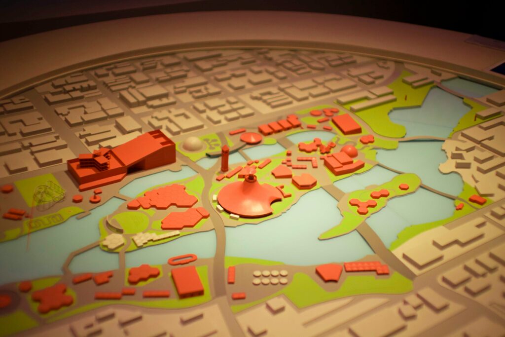
Urban Planning and Development
In Hobart, where the landscape is characterized by steep slopes, coastal environments, and a growing urban population, urban planning and development are becoming increasingly complex. Reality capture allows city planners and developers to create detailed, up-to-date 3D models of Hobart’s urban environment, helping to visualize and plan future developments, infrastructure upgrades, and land use projects.
City Mapping
Reality capture can be used to generate highly detailed 3D maps of Hobart, offering an accurate representation of the city’s topography, buildings, and infrastructure. This is crucial for planning new developments, zoning, and land use changes.
Simulations and Visualizations
Using the data collected, urban planners can simulate how new buildings or infrastructure will impact the existing environment, from changes in traffic flow to the visual aesthetics of the city’s skyline. This helps make informed decisions and improves public engagement with proposed projects.
Flood Risk Analysis
With its proximity to waterways, Hobart is vulnerable to flooding. Reality capture can be integrated with geographic information systems (GIS) to analyze flood risks and plan for effective drainage systems, flood barriers, and other mitigation measures.
Smart City Development
As Hobart moves toward becoming a more connected and sustainable city, reality capture data can contribute to the development of smart city initiatives. These models can be used to analyze traffic patterns, energy use, waste management, and other systems to optimize city services.
The ability to generate detailed, accurate, and interactive 3D models of Hobart’s urban environment helps planners make smarter decisions and foster sustainable, well-informed growth that takes into account both the city’s historical character and modern needs.
Environmental Monitoring and Management
Hobart’s natural environment is one of its key assets, with its proximity to Tasmania’s wilderness areas, coastal regions, and national parks. Reality capture technology can support environmental monitoring and management by providing accurate data for assessing landscapes, ecosystems, and natural resources. Using drone technology and LiDAR, environmentalists and researchers can capture detailed imagery and measurements of forests, rivers, coastlines, and wildlife habitats.
- Topographical Mapping: Reality capture can produce highly accurate topographical maps of Hobart’s natural landscape, helping environmentalists assess changes in terrain, such as erosion, landslides, or shifts in vegetation.
- Vegetation Monitoring: By scanning forests and other natural areas, reality capture can help monitor the health and changes in vegetation over time. This data can support conservation efforts and inform policy decisions related to land use and protected areas.
- Coastal Management: Hobart’s coastal regions are vulnerable to the effects of rising sea levels and storms. Reality capture can be used to monitor the coastline, track changes over time, and assist in planning coastal protection measures.
- Wildlife Habitat Mapping: By capturing detailed 3D models of natural environments, reality capture technology can support wildlife habitat monitoring and management, ensuring that ecosystems remain healthy and biodiversity is preserved.
In Hobart, reality capture technology plays a vital role in environmental protection, providing detailed insights into the health and changes of the natural landscape, and supporting more sustainable management practices.
The applications of reality capture in Hobart are diverse and impactful, ranging from the preservation of cultural heritage to the development of more sustainable urban environments. As the city continues to grow, reality capture technology will play an increasingly important role in ensuring that developments are accurate, efficient, and in harmony with both the built and natural environments. By embracing this cutting-edge technology, Hobart can lead the way in creating smarter, more resilient cities that protect its rich heritage while paving the way for future growth and innovation.
Future Trends in Reality Capture for Hobart
As reality capture technology continues to evolve, it is poised to play an even more significant role in the growth and development of Hobart. The city’s unique geographical features, historical significance, and rapid urbanization present both opportunities and challenges for future projects. The convergence of advanced tools, such as LiDAR, photogrammetry, drones, and artificial intelligence (AI), is shaping the future of reality capture and its applications. The trends we see today suggest that Hobart will increasingly embrace these innovations to drive sustainable growth, improve public services, and preserve its cultural heritage.
Increased Integration of Artificial Intelligence (AI) and Machine Learning
Artificial intelligence and machine learning are expected to play a critical role in the future of reality capture in Hobart. As data collection methods become more advanced, the sheer volume of data captured through 3D models, LiDAR, and drones is growing exponentially. AI and machine learning algorithms will be increasingly used to process, analyze, and interpret this data more efficiently and effectively.
Automated Data Processing
Currently, reality capture data requires manual processing, which can be time-consuming. With AI integration, data processing could become more automated, reducing the time and effort needed to convert raw data into usable models. AI can identify and classify features, such as buildings, roads, and vegetation, within the data without human intervention, speeding up workflows.
Enhanced Accuracy
AI models can be trained to recognize patterns and predict errors in the captured data. This will help increase the accuracy of the models, ensuring that the digital representations are highly detailed and free from inconsistencies.
Predictive Analytics
By integrating AI with reality capture data, city planners and environmentalists can predict future changes in Hobart’s infrastructure, environment, and urban growth. This predictive capability will allow for better long-term planning and management, particularly for projects related to climate change, population growth, and urban sprawl.
As AI continues to advance, Hobart can expect enhanced efficiency in data processing, with AI-driven insights making urban planning, construction, and environmental management smarter and more responsive to emerging trends.
Autonomous Drones for Scalable Data Capture
Drones have already revolutionized the way data is captured, and future advancements will only further enhance their capabilities. In Hobart, with its mix of urban, suburban, and natural landscapes, autonomous drones will increasingly become indispensable tools for reality capture.
High-Resolution Aerial Imaging
Future drones equipped with high-resolution cameras and advanced sensors will be able to capture more detailed aerial imagery and topographic data. This will provide Hobart’s planners and architects with ultra-precise models of entire neighborhoods, landscapes, or even the entire city, facilitating more detailed and accurate urban development.
Increased Automation
Autonomous drones will be able to perform flight paths and data capture autonomously, reducing the need for human intervention. This will be especially beneficial for capturing hard-to-reach or hazardous areas, such as steep terrains, coastal zones, or even dangerous infrastructure.
Large-Scale Scanning
Drones will allow for the scanning of vast areas in a fraction of the time compared to traditional methods. This capability is especially valuable for projects that require extensive data from large land parcels, like infrastructure development or natural resource monitoring in Hobart.
With autonomous drones, Hobart will benefit from quicker, more cost-effective, and scalable data capture for projects ranging from urban expansion to environmental conservation.
Real-Time Collaboration and Cloud Integration
One of the key trends in the future of reality capture in Hobart will be the greater use of cloud-based platforms to facilitate real-time collaboration among stakeholders. This will enable a more integrated and streamlined approach to project management across various industries.
Cloud-Based Data Sharing
Reality capture data, including 3D models, point clouds, and scans, will increasingly be stored in the cloud, making it accessible to multiple stakeholders simultaneously. Whether it’s architects, engineers, urban planners, or government officials, they will all be able to access the most up-to-date data from anywhere, improving communication and reducing the risk of errors.
Real-Time Updates
With cloud integration, updates to models and designs can be made in real-time, allowing for immediate feedback and collaboration. This will be particularly valuable for ongoing projects in Hobart, where stakeholders may need to make decisions on the fly based on the latest data.
Remote Collaboration
Cloud-based platforms will also make it easier for Hobart’s project teams to collaborate remotely. This is especially important in a post-pandemic world where remote work is more common. Teams from different parts of the city or even the world will be able to contribute to the project without the need to be physically present.
Real-time cloud-based collaboration will bring greater efficiency, transparency, and adaptability to reality capture projects in Hobart, enabling more effective teamwork and decision-making.
Enhanced Realism and Virtual Reality (VR) Integration
The next generation of reality capture models will offer even more immersive and realistic experiences, thanks to advancements in virtual reality (VR) and augmented reality (AR). As the technology continues to mature, Hobart can expect to see these virtual tools used to create more interactive models that can be explored in real time.
Immersive 3D Models
Virtual reality integration will allow users to walk through digitally captured spaces, offering an experience that is more engaging and informative than traditional 2D visualizations. For example, urban planners can use VR to “walk” through potential new developments in Hobart, providing a better understanding of how these spaces will function in the real world.
Augmented Reality for Field Work
Augmented reality tools will allow field workers, architects, and engineers to overlay digital information on real-world environments. In Hobart, this could mean overlaying 3D models of new infrastructure onto the existing landscape, allowing stakeholders to visualize how a development would look in a specific location before construction begins.
Public Engagement and Visualization
VR and AR technologies can also be used to engage the public in planning and development processes. Virtual tours of proposed developments, for instance, can provide residents of Hobart with an opportunity to explore and give feedback on projects before they are built, fostering greater community involvement.
With VR and AR, Hobart will see the development of more interactive and immersive ways to explore, design, and communicate about the city’s future, enhancing both professional workflows and public participation in the decision-making process.
Sustainability and Environmental Monitoring
As climate change and environmental sustainability become more urgent global issues, reality capture will increasingly be used in Hobart to monitor and manage the natural environment. The city’s proximity to fragile ecosystems and its vulnerability to natural disasters make it an ideal location for the use of reality capture technology in environmental conservation and sustainability efforts.
Carbon Footprint Analysis
Using reality capture, Hobart will be able to create detailed environmental models that track carbon emissions, vegetation changes, and other factors contributing to climate change. This data can be used to monitor the impact of new developments and help reduce the city’s overall carbon footprint.
Biodiversity Monitoring
In Tasmania’s unique ecosystems, reality capture technology can be used to monitor biodiversity by capturing 3D scans of forests, wetlands, and other natural habitats. This data can inform conservation efforts and guide decisions on the preservation of endangered species and critical habitats.
Disaster Preparedness
With reality capture, Hobart can create detailed models of the landscape to prepare for natural disasters such as floods, bushfires, and storms. These models can help identify at-risk areas and optimize emergency response plans, improving the city’s resilience to climate-related challenges.
In the coming years, Hobart will continue to benefit from the integration of reality capture technology in its environmental sustainability efforts, helping the city better understand and manage its natural resources.
The future of reality capture in Hobart is one of innovation and progress. With advancements in AI, drone technology, cloud computing, and immersive virtual environments, Hobart is well-positioned to leverage these tools to meet the challenges of urbanization, environmental protection, and heritage preservation. As these technologies become more refined and accessible, reality capture will continue to revolutionize the way Hobart’s planners, architects, and environmentalists approach their work, creating a more sustainable, connected, and informed city for the future. Whether it’s planning new infrastructure, preserving historical landmarks, or ensuring environmental sustainability, reality capture will be a critical component in shaping Hobart’s future.
Exploring FlyPix: Geospatial AI Solutions for Reality Capture in Hobart
Flypix is a platform revolutionizing geospatial data analysis by using AI to detect, outline, and analyze objects in images. This tool is ideal for reality capture projects in Hobart, where efficient data processing is crucial for industries such as construction, agriculture, and urban planning.
Key Benefits of FlyPix for Reality Capture Projects
- AI-Powered Object Detection: Quickly identifies and outlines objects in geospatial images, saving significant time.
- Custom AI Model Training: Users can train models to detect specific objects based on project needs.
- Multispectral Data Support: Capabilities to work with multispectral data for more detailed analysis.
- User-Friendly Interface: Allows for quick integration, even without deep AI knowledge.
- Efficient Processing: Ideal for managing dense, complex scenes without the need for manual annotation.
FlyPix can accelerate reality capture efforts in Hobart, making it an indispensable tool for professionals who need to process and analyze vast amounts of geospatial data quickly and accurately.
Conclusion
In Hobart, reality capture technology is making significant strides across various industries, offering precise and efficient methods for surveying, construction, and conservation. Its ability to create accurate, detailed 3D models has transformed how professionals approach design, planning, and monitoring. By leveraging technologies like LiDAR, photogrammetry, and drones, businesses in Hobart are gaining a competitive edge in accuracy, cost-efficiency, and overall project success.
With its broad range of applications, from architecture and construction to environmental conservation, reality capture is set to continue playing a crucial role in Hobart’s growth and development. As technology evolves, its capabilities will only expand, bringing even greater benefits to the region’s industries.
FAQ
Reality capture technology involves using tools like LiDAR and photogrammetry to create detailed 3D models of physical environments.
It is used for accurate site mapping, designing structures, and monitoring construction progress in real-time.
Construction, surveying, architecture, land management, and environmental conservation all benefit from reality capture technology.
LiDAR is a technology that uses laser pulses to measure distances and generate precise 3D models of objects and surfaces.
Yes, drones equipped with cameras or LiDAR sensors are commonly used for large-scale mapping and surveying.
The accuracy is very high, often within a few millimeters, depending on the technology used.
It is faster, more accurate, and allows for better visualization, reducing the risk of errors.
It creates digital records of historical sites, helping preserve architectural details and providing data for restoration efforts.